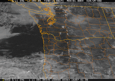
 In their most recent winter storm warning, the National Weather Service is forecasting about 12 hours of nasty... from 4 PM this afternoon to 4 AM tomorrow morning.
A DISTURBANCE WILL LIFT NORTH ACROSS THE FORECAST AREA THISTonight's forecast (from NOAA/NWS):
EVENING AND TONIGHT. PRECIPITATION ASSOCIATED WITH THIS
DISTURBANCE WILL FALL AS A MIX OF SNOW...SLEET AND FREEZING RAIN.
A TRANSITION FROM FROZEN PRECIPITATION TO RAIN WILL TAKE PLACE
FROM NORTH TO SOUTH LATE TONIGHT AND EARLY SATURDAY
MORNING.
SNOW ACCUMULATIONS IN THE CENTRAL AND SOUTH WILLAMETTE VALLEY ARE
EXPECTED TO BE AN INCH OR LESS...WITH THE POTENTIAL FOR UP TO 3
INCHES IN THE NORTH.
ICE ACCUMULATIONS ARE EXPECTED TO BE LESS THAN ONE QUARTER OF AN INCH.
.DAYS TWO THROUGH SEVEN...SATURDAY THROUGH THURSDAY
THE UPPER HOOD RIVER VALLEY...COLUMBIA RIVER GORGE AND AREAS NEAR
THE WEST END OF THE COLUMBIA RIVER GORGE MAY CONTINUE TO HAVE
WINTRY PRECIPITATION WELL INTO THE AFTERNOON HOURS ON SATURDAY.
AN EVENTUAL CHANGE OVER TO ALL RAIN IS EXPECTED IN THESE AREAS BY
SATURDAY EVENING AS THIS DISTURBANCE SCOURS OUT THE COLD AIR.
Tonight: Freezing rain likely before 4am, then rain, possibly mixed with freezing rain. Snow level 1500 feet lowering to 400 feet. Low around 22. Light east northeast wind. Chance of precipitation is 80%. Little or no ice accumulation expected.OK, the temperature has come up a little since I started on this, and the above is sounding more plausible. When I started it was 19 F; it's now 26. I ran off and messed with the above satellite image (current here) to illustrate the problem here in the Willamette Valley.
 In the above, I have marked the location of Corvallis (CVO is the call sign for the municipal airport), the Coast Range, the rough outline of the Willamette Valley, the Cascades, and some of the major peaks in the latter, visible due to snow that has already fallen this winter.
The Willamette Valley is like an enormous bathtub; cold air such as we've had over the last ten days or so tends to get stuck. If a warm, wet weather system moves relatively calmly off the Pacific, it will simply flow over the top of the colder, denser air stuck in the valley. If it drops rain, the rain can become supercooled (cooled below 32 F, but remaining liquid) as it falls into and through the cold air on the valley floor. When it hits the ground, it will then freeze on contact.
There are two factors here that make me feel a little optimistic: first, as I noted above, we are warming rapidly toward freezing. Once the clouds move in, sunlight can't warm us up further, and heat can't escape as effectively through IR radiation; clouds prevent rapid temperature change through radiative processes. I was worried we'd still be in the teens when the clouds moved in... if that had happened, we'd be stuck in the upper teens/lower 20's until the system physically moved out and replaced the cold air in the valley. Which leads to the second point: based on my reading, it looks as if the incoming system is indeed vigorous enough to get rid of the arctic air that's been sitting here for over a week, and fairly quickly too.
Another thing to be thankful for is that it's going to be mostly a night time event. Today is the last day of finals at OSU, and many people, including a number of friends, will be traveling either this evening or tomorrow morning. Tomorrow morning may not be pretty, but it doesn't look to be particularly dangerous. We'll see what time the precipitation starts, but it may not be until later in the evening. In any case, we may manage to squeak above freezing before that happens. When I was last outside, cloud banks were moving in from the west, but it was still sunny here. Looking out the window, it appears they've started to move out over the valley now, though it's still pretty bright.
Whatever the case, be safe, folks. Ice can be spotty, and icy pavement can look wet. Keep it slow and safe, and I'll see you after the new year.


No comments:
Post a Comment