Note: Dana and I pointedly planned this trip to coincide with a series of negative tides (those with low water elevations below the average of the lower of the two daily low tides) specifically so we had good, safe beach access, and a maximum extent of time to look at rocks exposed there. DO NOT takes chances with the Pacific Ocean. It's anything but "pacific," and it's very cold here in the PNW. Even the strongest and healthiest have little time to survive if they unexpectedly find themselves in the water and can't quickly get themselves out.
Day 1 (half day)
Stop 1, Yaquina Head- Columbia River Basalt reached the location of modern coast in a number of spots. Yaquina Head is one of them. Cobble Beach, a lovely beach of polished basalt cobbles and tidepools, and Quarry Access, a well-intentioned, but poorly geologically thought-out project to provide wheelchair access to tidepools. The inevitable result, which I predicted correctly just a few weeks after it opened and I visited it the first time, is reason enough to go down to the "tidepools" here. Aside from the geology, the visitor center is quite nice, and the views from the cliffs near the lighthouse are epic.
http://www.flashearth.com/?
 Looking north from near the lighthouse.
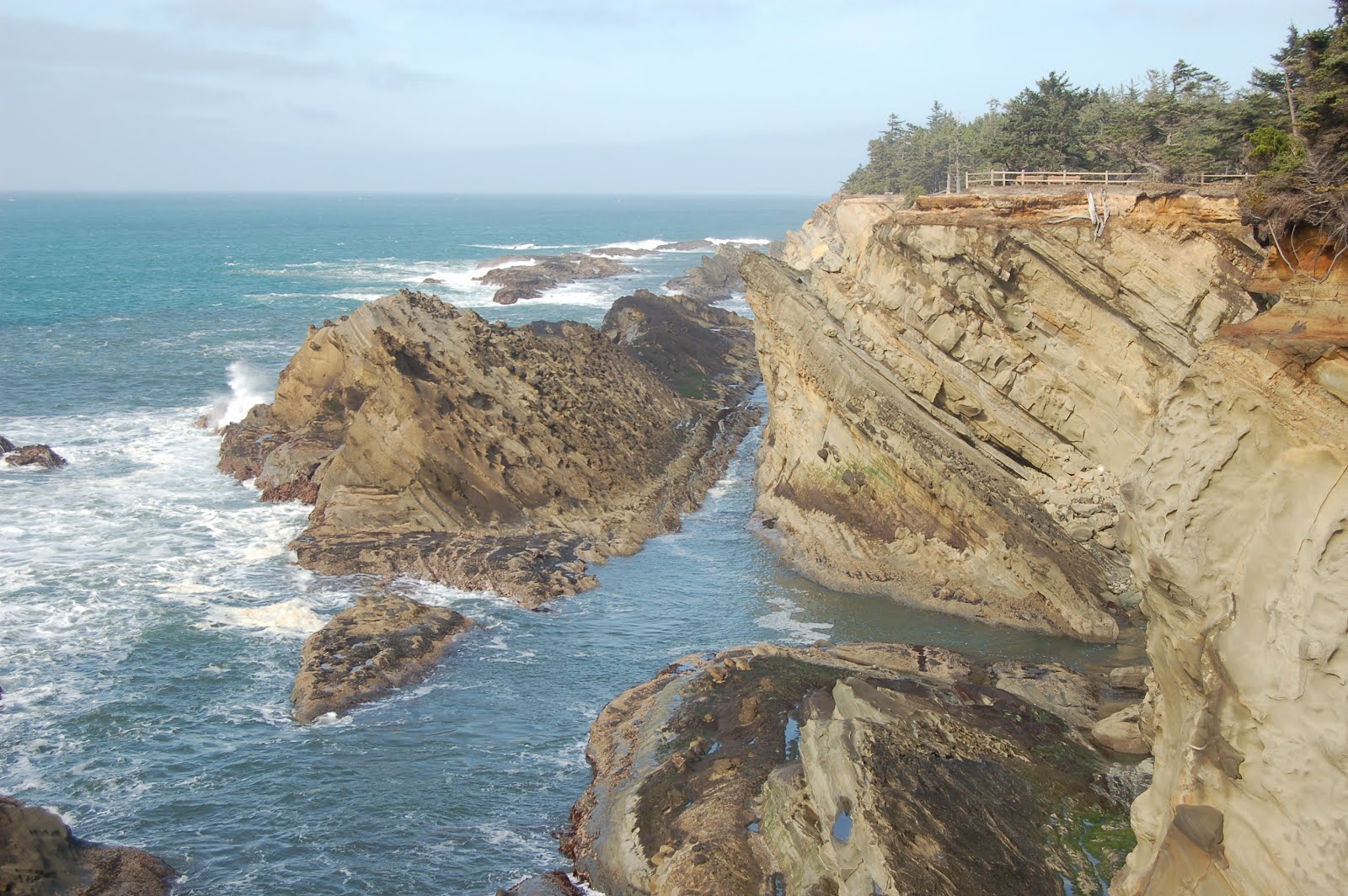
 Looking SE from lighthouse parking area, down onto Cobble Beach; Newport, OR in the distance.
 Cobble Beach
 Quarry Access "tidepools." An abandoned quarry was modified, pathways added, and opened to the ocean in hopes of creating a unique spot that allowed handicapped access to tidepool viewing. Unfortunately, I don't think any geotypes were involved. It was blatantly obvious from the outset that the site was an excellent sediment trap, and would not permit the high-energy wave environment necessary to create and maintain tidepools.
 Columns in Miocene Columbia River Basalt in the Quarry Access walls.
Stop 2, Beverly Beach State Park- Fossiliferous cliffs in Miocene Astoria fm- walk under highway bridge from day parking then turn left (south). Mud/siltstone has scaphopods that are difficult to collect; nicest fossils are in sandstone, past the muddy cliff. Collecting (I just learned on this trip) is technically illegal here. Sadly, I didn't see that until after we'd returned to the car. Oh well.
http://www.flashearth.com/?
 A sweet little gastropod which my have followed me home
 A resistant, well-cemented sandstone weathering and eroding along its joints.
 Same spot as previous, looking north, with Dana Hunter for scale.
 A typical fossiliferous boulder at Beverly Beach. Lens cap is ~52 mm. Scallop-looking critter is a pecten.
Stop 3: Devil's Punchbowl State Park- 1st, drive to lot at end of headland, for a nice view down into the namesake punch bowl. Then turn around and drive the couple blocks or so to the beach access parking between B and C Avenues. We went down the south cove, which was every bit as awesome as I remembered- haven't been down there since late 80's. North cove is a bit more of a walk (less so if you park in the overflow parking off 2nd, west of C), but also has good geology exposed, plus, if you go during a good tide, you can get an interior viewing of the punchbowl. If you choose to do this, keep a very close eye on the water... people have been trapped there. Don't recall anybody dying, but it's scary and expensive. Yes, they pass as much of the cost on to the rescued as they can.
http://www.flashearth.com/?
 Devil's Punchbowl- color/contrast tweaked to bring out details down in the hole, so lip is completely washed out.
 Looking west, toward first point, south cove, Devil's Punchbowl State Park.
 Clastic dike, not too far from base of stairs, south cove, Devil's Punchbowl State Park.
 Cute little pair of faults a little ways further along from clastic dike.
 View around the first point in south cove...
 ...where the rock is full of marcasite nodules like this one.
 Sea cave around second point in south cove
Day 2:
Stop 1, Seal Rock- Quick stop for overview from terrace, didn't go down to beach. Nice beach, but geologically there are more interesting places. Major importance of this spot is that it's the southernmost spot known where CRB reached the location of modern coast.
http://www.flashearth.com/?
 View to the north from top of elevated terrace at Seal Rock.
 View to the south. Between these two views, you can see this is an "invasive" dike. A subaerial flow of CRB reached unconsolidated sediments at the Miocene Coast, then intruded down into them. This is not uncommon along the central to northern Oregon Coast, but it is a sort of odd situation; "intrusive lava" ought to be an oxymoron, but there it is. It was beginning to be suspected, during the 80's when I was an undergrad, that this was indeed the case, but by the time I finished up, it was only accepted firmly for some of the more northerly occurrences. At this point it seems to be accepted for most of the isolated, younger basalt headlands north of the Yachats Basalt headlands, which can be seen on the horizon in the distance in the second photo. (Also, to try to avoid confusion, the basement rock of the Coast Range is Siletz River Volcanics, sea floor and oceanic plateau basalt, and it shows up in some outcrops along the northern coast too, but it's older, Eocene, and shows typical oceanic basalt features such as brecciation and pillows.)
Stop 2: Coming down off headlands toward Florence, there are some pull-outs with nice views out over the Dunes. Another quick stop to admire the scenery and snap a few photos.
http://www.flashearth.com/?
 View to the south, coming down off Yachats Basalt headlands, looking south over the dunes.
Aborted stop, but nice and recommended: Honeyman State Park. In the Oregon Dunes, wind-blown sand has blocked numerous streams, so there are numerous fresh-water lakes, which drain to the ocean only by groundwater movement. Cleawox Lake at this park is a good example. The forest here is also beautiful, and the dunes are some of the best I knew of until I found Eel Creek... though at my age, I'm less thrilled than I used to be at climbing up hundreds of feet of loose sand.
http://www.flashearth.com/?
Stop 3: Oregon Dunes Overlook roadside rest area- Not the best place to see Dunes, though my nephew had a blast running and falling down them here when he was out a few years back. The outstanding thing to see here is the various stages of succession from open sand, to grass, to low shrubs, to larger shrubs and shore pines, to mature Douglasfir forest. From the overlook viewpoint, you can see examples of each of the stages from one spot, and see just how disorderly and patchy the process really is, while at the same time, being able to clearly see the progression. Perhaps the only thing missing is a clear example of forest being swamped and killed by advancing dunes, starting the process anew. But you can see that at the next stop...
http://www.flashearth.com/?
 Looking more or less south from dunes overlook: nice stand of isolated, mature Douglasfir.
 Looking out toward coast, dunes overlook.
Stop 4: Eel Creek- Park at the day use area, which I'm pretty sure I have in the cross-hairs. (The campground entrance is about a half mile further to the north, and is a nice spot to stay with kids. On field trips with HS students, we've stopped at other places and this can be a convenient place to know about.) It's about a half mile walk in through lush coastal forest, and you come out onto the open dunes rather abruptly. DO take a moment to look around and note prominent landmarks... it's easy to lose your bearings on open sand, especially if you get out of view of the spot at which you came in. This location features some of the nicest dunes I've seen in my life. The large dune to the south of the trail's egress into the sand is relatively easy to get up if you walk to its eastern end, then follow the ridge crest up. From the top, the view to the south reveals coastal forest being overrun by advancing sand, as well as seemingly endless ridges of it out into the distance. Extremely mesmerizing and memorable.
http://www.flashearth.com/?
 Emerging abruptly from the forest onto the sand.
 View to the southeast of forest being killed by advancing dune- though as you can tell from the grasses established along that slipface, the process is sporadic, not a steady, gradual one.
 View south. Note slumping of slip faces on dunes in mid-distance.
 Dana looking at some sweet cross-bedding.
 Sand saltating across the top of the dune. Yes, it was windy.
Stop 5: Shore Acres State Park- Coos Bay (the bay itself, not the town) lies on the axis of a progressively folding syncline; younger beds are less steeply dipping than older beds. The triplet of state parks along this section of coast are my favorite Oregon coast locations- and I love the coast, so that's no small compliment. Shore acres has numerous features to explore. You can get to sea level in the south cove, but for the most part, I've been content to simply explore the top of the terrace here. The elevated terrace, incidentally, shows a noticeable increase in elevation from north to south, from Sunset Bay to Shore Acres, to Cape Arago, respectively. The views are breathtaking here; a shot taken near the shelter house is the first photo I've preferred to blank, undistracting gray as my desktop image. Cannon Ball Rock is covered with large concretions, and there are some lovely examples of tafoni weathering on the platform north of that. Looking down into the cove from that platform at low tide, one can see several faults criss-crossing the new wave-cut terrace. If you want to spend some time not doing geology, the gardens are very nice. However, just strolling the path along the cliff and enjoying the scenery can burn plenty of time too. This is the spot to spend your time when the tide is still up; the other two are best visited at low tide.
http://www.flashearth.com/?
 Looking north toward Cannonball Rock- my current desktop photo.
 Dana on walk around to Cannonball Rock, giving sense of scale to fence behind her, and in turn to fence both in the distance and in the previous photo.
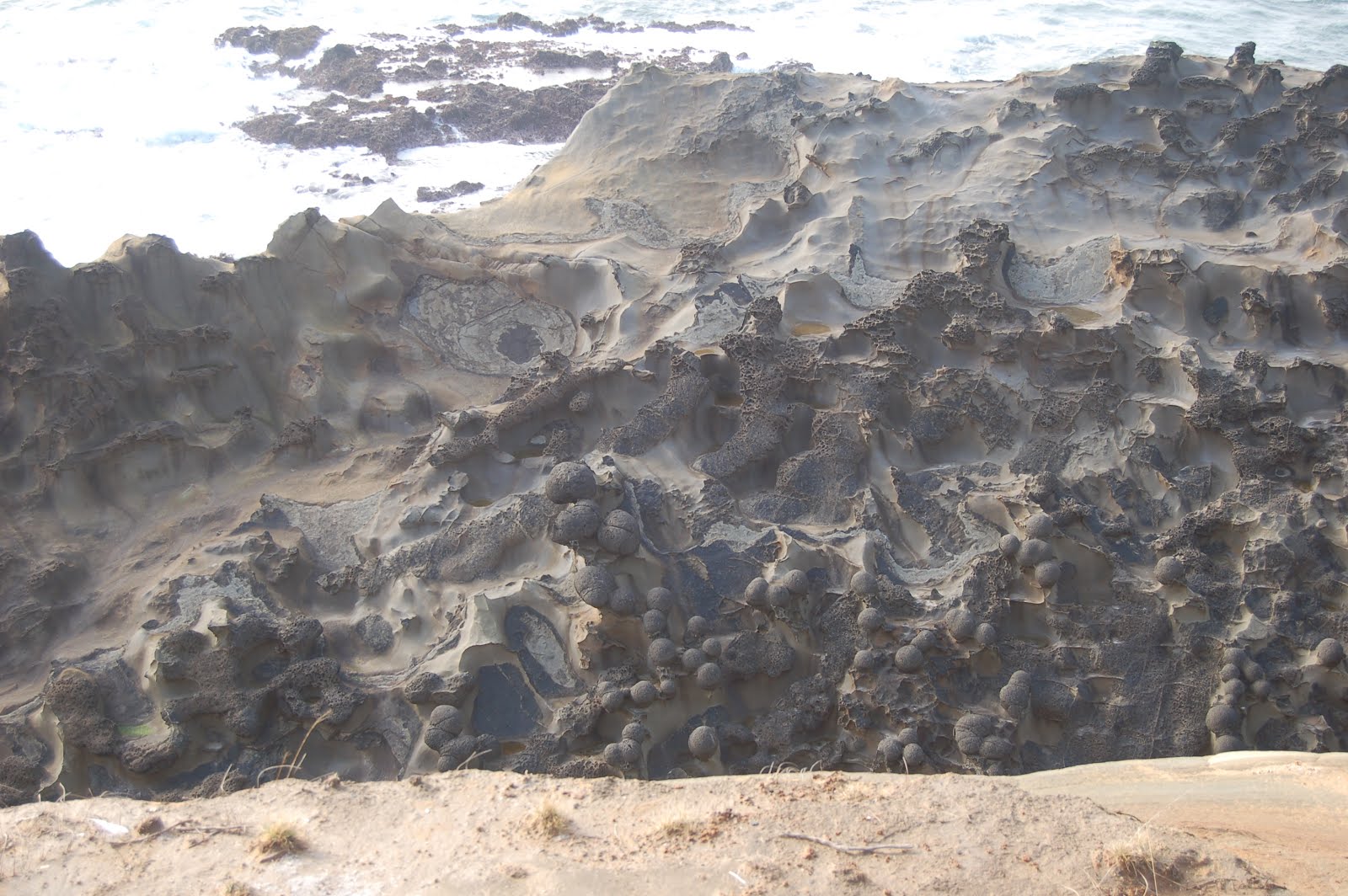 Large concretions give Cannonball Rock its name.
 Tafoni weathering on terrace surface where younger sediments have eroded off, exposing tilted bedrock, south of Cannonball Rock.
Stop 6: Simpson Reef overlook- Most people want to look at the seals and sea lions that haul out on these offshore rocks. Geologists take one look at that zigzag pattern and go "Ooh! Plunging syncline-anticline pair!" Can't remember which is which right now... I'll look it up later.
http://www.flashearth.com/?
 Simpson Reef
Aborted Stop, but highly recommended: Cape Arago- we were getting pressed for time, and choosing between walking down yet another flight of stairs to spend low tide at Cape Arago, or driving back North to Sunset Bay was a no-brainer. Structurally though, and in terms of diverse geology, Cape Arago is the gem of these three parks. Ideally, one should set aside two low tides at this park, one for the south cove and one for the north cove- I don't think the middle cove is safely accessible. North Cove: some great folds, enormous cut-and-fill channels, some kewl sed structures. South Cove: some excellent sed structures, coalified driftwood, hidden but fairly easily inferrable fault. Good tidepools. The FlashEarth imagery does a nice job of highlighting the erosion into criss-crossing faults on the sandstone headland itself.
http://www.flashearth.com/?


