Saturday, June 14, 2014

Geo 730: June 14, Day 530: Coal

I'm not sure "coal" would technically be the correct name for this. I think of coal as a bedded rock rather than a discrete piece of a rock, and this looks to me as if it's a single tree limb or trunk that was deposited in the sediment. There were other bits around, so it wasn't unique, but it was the largest we saw. My understanding of sedimentary facies is rudimentary at best, but I'd guess this was offshore; we're not in a coastal swamp or anything. Supporting this, if you look back at yesterday's photo, you can see that the surrounding sediment was overall fairly course and poorly sorted. So the current must've been pretty brisk. But that same photo would indicate we're not too far offshore. If that were the case, the coarser gravel wouldn't have reached this far. So the "coal" in this case was probably a waterlogged chunk of wood that sunk and got mixed in with the sedimentary pile.

Photo unmodified. March 9, 2012. FlashEarth location. (This is probably accurate to within 10-20 miles. Sorry, no clue.)

Friday, June 13, 2014

Geo 730: June 13, Day 529: Locked Wood

I misremembered this stop... I recalled that we were looking at bedrock outcrop, but this is clearly a loose boulder. However, it does look lithologically similar to the outcrop across the road, which we couldn't get at for reasons of safety and rockfall controls. What we're seeing here is probably deltaic or near-deltaic facies of the Tyee Formation. I've never seen such coarse-grained Tyee before, and that by itself was pretty exciting to me. The other feature that was particularly thrilling is the piece of coalified (as opposed to mineralized or permineralized) wood that Dana is looking at in the photo.

I have a workshop and field trip up Marys Peak tomorrow, and while I've got the photo picked out, if I don't get that post written up and scheduled, it may not go up until Sunday. So if day 530 doesn't show up tomorrow, don't worry. I'll be out beating up on rocks. More distal facies of the Tyee, in fact.

Photo unmodified. March 9, 2012. FlashEarth location. (This is probably accurate to within 10-20 miles. Sorry, no clue.)

Thursday, June 12, 2014

Geo 730: June 12, Day 528: Looking Back

I was seat-buckled in, so I couldn't exactly crane out the window to look back myself... but my camera could. Most of the photos I took in the work area were too blurry to be of any interest, but despite the weird angle of this one, you can see the runout of the rock fall crossed the road, apparently took out the guard rail, and went down the river bank. Western Oregon's mild, wet climate, combined with the rapidly weathering sediments in the Coast Range, and mixed volcanics and sediments in the Cascades, means that various forms of mass movement are a constant threat along transportation corridors in rugged areas. Once, it seemed nuts to me that so much money was spent to build and maintain roads in areas like this, where one can confidently predict there will be a road closure at least once a year, on average. However, the economic and social benefits of having dependable mobility between cities and towns is likely multiple times the costs involved.

Photo unmodified. March 9, 2012. FlashEarth location (Fairly confident about this one, but not certain).

Wednesday, June 11, 2014

Geo 730: June 11, Day 527: Rubble Removal

Here we see the excavator removing some of the debris from the rockfall. The operator may be simply loosening the pile up at this point; I don't see where it might be moved *to.* Normally, I'd expect a dump truck to be backed up nearby to remove the rubble. It's not terribly obvious from this shot, but the original runout extends past the guard rail on the far right. I can't tell from the photos I have, but it looks as if the rail was taken out entirely in that area.

Photo unmodified. March 9, 2012. FlashEarth location (Fairly confident about this one, but not certain).

Tuesday, June 10, 2014

Geo 730: June 10, Day 526: Order and Chaos

Here we have a clearer look at the rockfall, though the truck ahead is still blocking the base from view. An excavator is clearing up some of the debris pile on the far right, and I suspect it later worked to the left to remove some of the rubble in that area. It would make sense to try to take this down to more or less bare bedrock, so rain wouldn't wash more muck out onto the road. Above the front-end loader near the middle, you can get a pretty good sense of the stratigraphy here. It seems to me to be less rhythmic than our earlier stop, and again, there are some strata that look to be quite organic-rich. Drive-by geology is often less than satisfying, but with a camera and a good regional understanding, one can garner a surprising amount of information in a mere 30 seconds.

Photo unmodified. March 9, 2012. FlashEarth location (Fairly confident about this one, but not certain).

Monday, June 9, 2014

Geo 730: June 9, Day 525: Work in Progress

The rockfall clearly took place in the slope above and to the left of the truck ahead of us. Given what I can see here, my suspicion is that weathering and erosion of the mud/siltstone undercut the thick sandstone layer visible to the left of the light tower. With support removed, that sandstone layer then spalled off, and down into the road. Again, this is just a drive-by guess, but it fits well with what one can see in the photo.

Photo unmodified. March 9, 2012. FlashEarth location (Fairly confident about this one, but not certain).

Sunday, June 8, 2014

Geo 730: June 8, Day 524: Signs of the (Rock) Fall

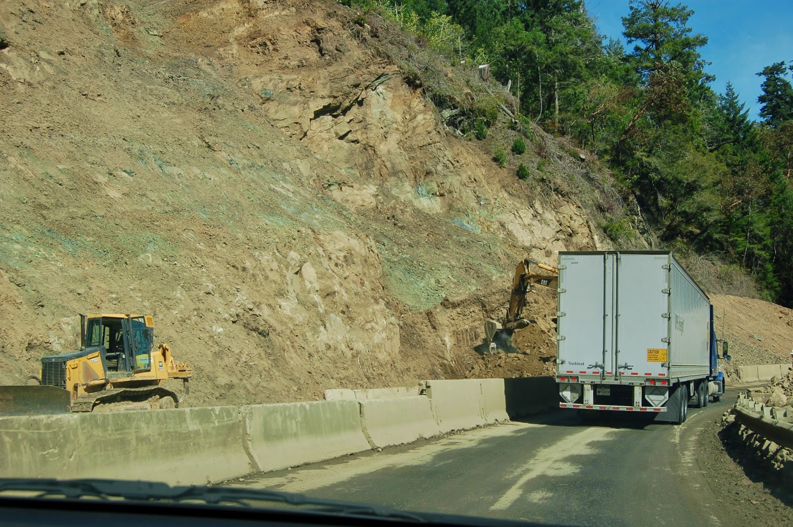
Sure enough, a few hundred feet on from yesterday's photo, there were rocks! I suspect we were pretty lucky in our timing here; this was quite possibly impassable a few hours earlier. While "fall" in terms of seasons and dendrology comes between summer and winter, in terms of rocks, it can come at any time of year. However, it's most likely to come after prolonged and heavy rain, which often means mid-winter to early spring in this part of the world. This was not a spot for a leisurely pull-out and poking around; the heavy equipment was a little unnerving as we drove by. So I can't say with any certainty exactly what caused this, but that won't stop me from speculating over the next few days. I'd be surprised if the fact it was early March was completely irrelevant.

Speaking of rock falls, Twitter and IRL geofriend, Hollie (@GeoHols), was up the Sandy River Canyon on her way to the Columbia Gorge a few days ago with a geology class on a trip from Portland Community College, and saw a rock fall first hand. This is a great thing to have planned for a group of beginning geology students! ;-)

Photo unmodified. March 9, 2012. FlashEarth location (Fairly confident about this one, but not certain).

Sunday Funnies: Get Off the Bus Edition

Pleated Jeans
Tastefully Offensive
Bizarro
Tastefully Offensive
Darius Whiteplume
ArtJCF
Biologically Queer
Corinne's Butt
Mr. Lovenstein
Things in Squares, via Tastefully Offensive
Clay Bennett
Gemma Correll
Tastefully Offensive
Abstruse Goose
JCF Art
Texts From TNG
Bits and Pieces
Tastefully Offensive
Funny to Me
Sober in a Nightclub
Fowl Language Comics
Depressed Alien
Tastefully Offensive
Balloon Juice
Sober in a Nightclub
Pablo Stanley
Sober in a Nightclub
Fake Science
Tastefully Offensive
Bad Newspaper
Reddit
 Imgur
ExtraFabulous Comics
Sober in a Nightclub
Actually, that's kind of an old spoiler. Senor Gif
Bad Newspaper
Texts From TNG
What Would Jack Do?
Sober in a Nightclub
"That's an important weapons system." Bad Newspaper
Texts From TNG
I Hate My Parents (several more creepy photos of McD's creepy new Happy Meal mascot at the link)
Cheexburger
Abstruse Goose
Tastefully Offensive