Madness, Our House:
Peter Gabriel, Solsbury Hill:
Joe Jackson, Real Men:


Is This Your Hat?
12 years ago
 (Skull Swap)
 (EpicPonyz) He's a seriously badass collection of organic molecules. I love it when related things come up in different places for no apparent reason other than to amuse me. Speaking of which, this is another collection of organic molecules that needs to happen:
 (The Daily What) I'd call it a Tyrannitauricorn.
 USGS Photograph taken on April 10, 1980, by Tom Casadevall (from the NE)
 USGS Photograph taken on April 10, 1980, by Tom Casadevall (also from the NE)
April 10 - Weather cleared to permit aerial observations of continued explosions from a circular vent about 30 feet across in the western part of the crater. Harmonic tremor was detected for the first time in three days.Emphases in the above passage are mine. One of the aspects of pre-eruption events that is difficult to express in view of 20-20 hindsight was just how mundane it started to seem to non-geologists. I particularly recall the indignation of those involved in the timber industry, who felt they were unfairly- even illegally- being denied access to their livelihood. I felt a certain sympathy for their point of view, but at the same time, had a hard time comprehending how they could be so eager to rush toward a potential bomb. But as time went on, the constant complaining about the costs of maintaining the road blocks, and the forgone costs of shutting down the largest source of income in the area, became more and more compelling to those of us in the public with, shall we say, a certain degree of geological innocence. From here:
Steve Malone of the University of Washington reported that there had been 101 earthquakes with magnitudes larger than 4.0 since March 27.
The Cost of an Eruption - Explosions and earthquakes had settled into a monotonous pattern with no end in site. Mounting expenses began to affect the level of monitoring and maintenance of roadblocks.
Since March 20 the USFS estimated expenditures at $157,000. Skamania and Cowlitz Counties had spent $17,000 and $10,000, respectively, for their part in maintaining the roadblocks leading to the mountain.
The National Guard estimated costs of $3,800 per day since April 5 for their part in staffing roadblocks. Washington State Patrol spent over $5,000 for their part of this effort.
In order to reduce costs, the USFS grounded both observer planes, but kept one on standby in the event of an eruption. They also closed the press center at the Shilo Inn, ending twice daily briefings. Days before the USGS had reduced the number of scientists monitoring the volcano from 30 to between 5 and 10.
On April 10, residents and workers were allowed to return home after signing a release, which stated they knew the risks and accepted responsibility for their own safety. That same day Mount St. Helens erupted sending steam and ash fifteen thousand, five hundred feet above sea level. By this time the bulge was three hundred and twenty feet high.While I'm drawing much of the meat of these posts from available online sources, and it is difficult for me to recall, 30 years later, exactly what was going through my head on what date, I firmly remember that late April and May, up to the eighteenth, were, frankly, dull. It seemed like the same thing, over and over and over. Comparison of old photos to recent ones showed the north-side bulge distracting from the mountain's former symmetry. And as days went on, it became even more lumpy than before. It seems odd, in retrospect, to claim that what was to become one of the most important US geological events of the 20th century was preceded by a growing sense of boredom and apathy. A sense that what were, in retrospect, trivial expenditures to keep people out of harms way became so onerous that public officials chose to quit making those expenditures. But that's what I remember; while I had avidly been locating and reading as much as I could find up to this point, the mountain was becoming more monotonous background noise than something of real interest.

Map view of elevation changes (in feet) on the north flank of Mount St. Helens between August 1979 and April 7, 1980. Dashed line outlines the May 1980 crater. Red contours are negative values, blue contours are positive values (figure modified from USGS Professional Paper 1250, p.126).(From the chronology at the Mount St. Helens Volcanic Monument web page) No, what really grabbed my attention was that behind the clouds of the last few days, the formerly two discrete summit craters had merged into one enormous, gaping, hole.
 (USGS Photograph taken on April 7, 1980, by Peter Lipman, from the USGS pre-eruption photo archive.)
 (USGS Photograph taken on April 6, 1980, by James G. Moore, from the USGS pre-eruption photo archive.) To me, at least, this was really starting to look like a real volcanic eruption, not just indigestion. Again referring to the pre-eruption chronology, it is stated that
When the new (1980) map was compared to the old map, it showed that parts of the north flank had moved outwards by over 300 feet! Although the aerial photos were taken on April 7, the new data on the bulge was not available to scientists until April 23.And today's entry:
April 7 - The crater's dimensions measured approximately 1700 feet long by 1200 feet wide and 500 feet deep. Scientists obtained their first clear view of the vent at the bottom of the deepest part of the crater. A single circular "throat" about 20 feet in diameter was visible.
They also reported the first observations of substantial ponding of water. Two pools of muddy water large enough to float chunks of ice disappeared with each explosion then returned as more water accumulated after the explosion subsided.
The overall seismicity remained about the same and harmonic tremor was recorded for the first time in two days. Earthquakes were centered beneath the north slope at depths ranging from one half to three miles. USGS scientists installed a new tiltmeter at the Timberline Viewpoint.
While I know that the region's newspapers were talking about the bulge, and even a generally geo-ignorant person such as myself could see the changes in shape in the before and after pictures, I don't think most of us in the general public really perceived the magnitude of the mountain's expansion. And I know we (the public, that is) didn't perceive the danger inherent in oversteepening a mountainside over a fresh, hot magma chamber.
I just tracked down a tidbit of information I've been watching for; contrary to a point I made in a previous post,
Reexamination of ash samples from several precursory events shows that small amounts of juvenile material were erupted as early as 28 March 1980, just two weeks after the first seismic signals of reawakening, and that the juvenile content of the ash had probably increased by early May. The magmatic component of these eruptions was not recognized at the time because of the high crystallinity of the juvenile material—a signature of extensive degassing-induced crystallization during magma ascent.K.V. Cashman and R.P. Hoblitt, Geology; February 2004; v. 32; no. 2; p. 141-144; DOI: 10.1130/G20078.1
 From The Unofficial Addams Family Movie Sights Page, and continuing the apparent tradition of including a quote with these silly pictures, [when asked about her Halloween costume] "I'm a homicidal maniac- they look just like everyone else." (from Wikiquotes)
 Update, 5:51: AP chimes in, and Reuters has an update saying the tsunami watch has been canceled. Electricity is out in some areas, but it doesn't sound as if the damage is too bad.
 Release the Hell Hound!
 (Epic Win) I'm assuming the above photos are from the ongoing eruption at Fimmvörduháls Pass in Iceland. (I have previously identified this as the "Eyjafjallajökull" volcano; that name more properly refers to the ice sheet to the west of the volcano.) There have truly been some spectacular pictures from this eruption. While there is potential for the fissure to extend farther and cause serious problems, thus far it's been active enough to be a real show, but gentle enough to allow people to get up close and personal.
 NASA's Earth Observatory posted a new satellite image of the area yesterday. Note that north is to the right, not the traditional top, in this image. (The full-size image can be seen here, and an older image here.) Geology Rocks posted this picture of a lavafall (Click for full size at Flickr: Those are cars parked around the base!)
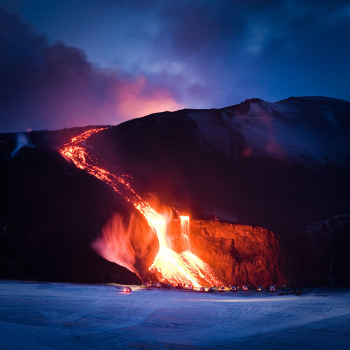 Blair Grylls at Mountain Cat Geology found an even better one:
 If you take a look at the full-size photo, you can clearly see a dragon head and neck rising from the mid slope below the lavafall.
 (Criggo) Actually, that's not quite as obvious and silly as you might think at first glance. Fires, landslides and broken utility lines can all add to the damage. For example, the Wikipedia entry for 1906 San Francisco Earthquake makes this claim:
As damaging as the earthquake and its aftershocks were, the fires that burned out of control afterward were even more destructive. It has been estimated that up to 90% of the total destruction was the result of the subsequent fires.Likewise, for the 1923 Great Kantō earthquake:
Because the earthquake struck at lunchtime when many people were using fire to cook food, the damage and the number of fatalities were augmented due to fires which broke out in numerous locations. The fires spread rapidly due to high winds from a nearby typhoon off the coast of Noto Peninsula in Northern Japan and some developed into firestorms which swept across cities. This caused many to die when their feet got stuck in melting tarmac; however, the single greatest loss of life occurred when approximately 38,000 people packed into an open space at the Rikugun Honjo Hifukusho (Former Army Clothing Depot) in downtown Tokyo were incinerated by a firestorm-induced fire whirl. As the earthquake had caused water mains to break, putting out the fires took nearly two full days until late in the morning of September 3. The fires were the biggest causes of death.So, yes, it does seem obvious that the shaking is the dangerous part, but there can also be secondary consequences that make a disaster even greater.
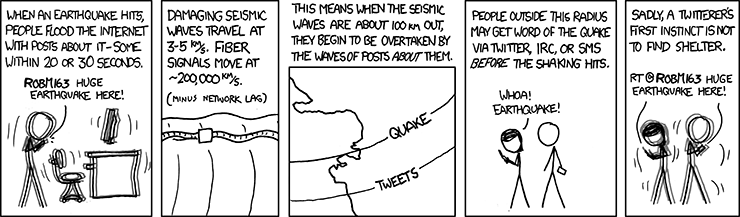 There's actually quite a bit of useful information in that comic. We're accustomed to thinking of sound waves as traveling a mile in 5 seconds (count the seconds between the lightning flash and the thunder, divide by five), but earthquake tremors, some of which are "sound," travel much, much faster: 3-5 km (1.8 to 3 miles) per second, or 9-15 times faster than sound in air. Very powerful, very disruptive and very fast. I've read accounts of quake witnesses describing dust being raised, but I don't think I've ever seen a picture as striking as this one, from NBC Local on Tumblr.
 The caption reads,
Brothers traveling in Mexico during Sunday’s deadly earthquake photographed this surreal sight: The power of the quake lifting a layer of dust off a mountain range.CNN also has a video clip from the area.
The dramatic photographs were shot by Roberto and Adrian Marquez Marquez just after the 3:40 p.m magnitude 7.2 quake. The pictures show the area around La Rumorosa, the highest point in Tecate.
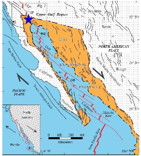 There is common misunderstanding among non-geologists that major tectonic boundaries like this are simple lines- single faults- that are sharp and distinct. "Every one knows" the San Andreas Fault is the boundary between the North American Plate and the Pacific Plate; the truth, as is so often the case in geology, is much messier
 Here's roughly the same location in Flash Earth. If you go explore the area, you can see that the cone in the lower right of the above picture is a northern outlier of a field that stretches quite a ways; my estimate is about 35-40 miles.
 It's not clear to me whether this is a natural de-watering structure or a broken main, and the caption doesn't really help...
On Monday, a man walks on cracked mud caused by underground water that leaked to the surface during Sunday's 7.2-magnitude earthquake in Mexicali, Mexico.It does appear to be running down the middle of a street, so I'm leaning toward broken water line. Still, I have read about sand blows in the area- not surprising in a delta area- so I can't be certain. The CSM also has a gallery of some of the damage in the area. Some of the damage looks pretty bad, but it doesn't look devastated. And I have been relieved to read that, at least so far, there are only two fatalities associated with the quake; one of those was apparently a man who panicked and ran in front of a car.
China is the world’s largest consumer of coal, burning more than the United States, the European Union and China combined. China has rapidly increased its imports in the past year, partly because domestic supply has not increased fast enough to keep up with power plants coming on line.Okay, dumb mistake in a serious story. A freighter has run onto the Great Barrier Reef off the coast of Australia. My first impression seeing this earlier was that it was an oil tanker; I was mistaken. Its primary cargo is coal, but there are about 1000 tons of bunker oil aboard, and early reports are that some of this fuel is leaking. There appears to be optimism, though, that the oil can be pumped off the ship before too much more leaks.
 Followup: I went to get a screen capture of the mis-phrasing above, and it has already been corrected to what I assumed was meant in the first place. "China is the world’s largest consumer of coal, burning more than the United States and the European Union combined."
 The Daily What
 Blackadder
 Blackadder This gag will be back.
 Obviously not Texas. Oddly Specific
 Criggo... and the other 47% weren't polled.
 Criggo
 Darius Whiteplume's Tumblr
 Saturday Morning Breakfast Cereal
 Sober in a Nightclub
 Calamities of Nature
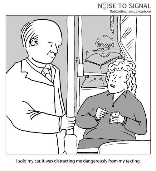 Noise to Signal. The discussion about this comic is worth reading, and contains the LOL line (regarding areas banning texting while driving), "It’s having an impact. I’m noticing a sharp reduction in “Totally just ran someone over” tweets from friends."
 God Hates Protesters
 Pundit Kitchen
 Skull Swap
 Skull Swap
 Bits and Pieces
 Bits and Pieces
 Regretsy; posted with the caption, "Jesus Christ, the guy’s been dead 9 months and he’s still all over your kid."
 Noise to Signal
 Think that's funny? Try pronouncing it... Criggo
 Frazz
Frazz Pundit Kitchen
 Friends of Irony
 Bits and Pieces
 Engrish Funny
 Night Deposits
 Oddly Specific
 Loltheist
 Totally Looks Like
 Shakeface! Acting Like Animals
 Cyanide and Happiness
 That Will Buff Out
 Epic Ponyz
 For all its wonderfulness, western Oregon is infamous for making people's allergies go nuclear. My nose is so raw, I think it would feel better to just cut it off. With a dull serrated knife. PhD Comics.
 One of the more amusing bits of news this past week was that the creative spelling and grammar that so often graces these signs was given a name: teabonics. God Hates Protesters.
 Sober in a Nightclub
 Saturday Bulletin
 Blackadder
 Mushroom (Cloud) Pizza, Bits and Pieces
 Sober in a Nightclub


