 (Criggo) Actually, that's not quite as obvious and silly as you might think at first glance. Fires, landslides and broken utility lines can all add to the damage. For example, the Wikipedia entry for 1906 San Francisco Earthquake makes this claim:
As damaging as the earthquake and its aftershocks were, the fires that burned out of control afterward were even more destructive. It has been estimated that up to 90% of the total destruction was the result of the subsequent fires.Likewise, for the 1923 Great Kantō earthquake:
Because the earthquake struck at lunchtime when many people were using fire to cook food, the damage and the number of fatalities were augmented due to fires which broke out in numerous locations. The fires spread rapidly due to high winds from a nearby typhoon off the coast of Noto Peninsula in Northern Japan and some developed into firestorms which swept across cities. This caused many to die when their feet got stuck in melting tarmac; however, the single greatest loss of life occurred when approximately 38,000 people packed into an open space at the Rikugun Honjo Hifukusho (Former Army Clothing Depot) in downtown Tokyo were incinerated by a firestorm-induced fire whirl. As the earthquake had caused water mains to break, putting out the fires took nearly two full days until late in the morning of September 3. The fires were the biggest causes of death.So, yes, it does seem obvious that the shaking is the dangerous part, but there can also be secondary consequences that make a disaster even greater.
The point of this post is to discuss the 7.2 quake near the Mexico-US border Sunday afternoon; the geoblogosphere, as always, has been great about discussing and clarifying this event. Keeping with the light-hearted tone for the moment, at least three people posted or shared this xkcd comic:
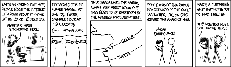 There's actually quite a bit of useful information in that comic. We're accustomed to thinking of sound waves as traveling a mile in 5 seconds (count the seconds between the lightning flash and the thunder, divide by five), but earthquake tremors, some of which are "sound," travel much, much faster: 3-5 km (1.8 to 3 miles) per second, or 9-15 times faster than sound in air. Very powerful, very disruptive and very fast. I've read accounts of quake witnesses describing dust being raised, but I don't think I've ever seen a picture as striking as this one, from NBC Local on Tumblr.
 The caption reads,
Brothers traveling in Mexico during Sunday’s deadly earthquake photographed this surreal sight: The power of the quake lifting a layer of dust off a mountain range.CNN also has a video clip from the area.
The dramatic photographs were shot by Roberto and Adrian Marquez Marquez just after the 3:40 p.m magnitude 7.2 quake. The pictures show the area around La Rumorosa, the highest point in Tecate.
The Berkley Seismological Laboratory's Seismo Blog presented a nice tectonic diagram showing the nature of the faults in the area. The bold red segments with approximately N-S to NE-SW orientation are actually little segments of oceanic ridge, where hot rock rising from within the earth partially melts to create basalt and new oceanic crust. The lighter red segments with NW-SE orientations are right-lateral strike slip faults, like the San Andreas Fault. The "SAF" in the upper left corner marks the southern-most end of that fault.
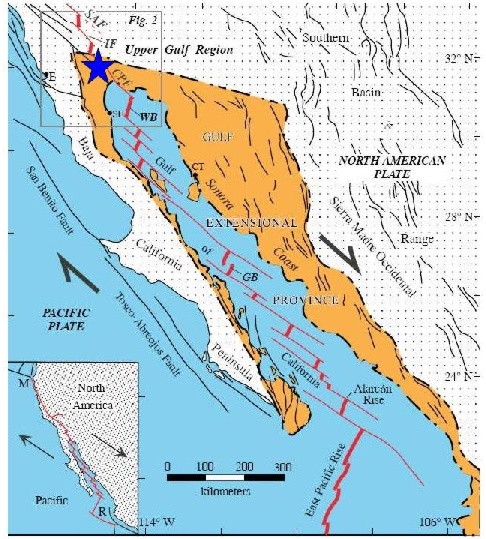 There is common misunderstanding among non-geologists that major tectonic boundaries like this are simple lines- single faults- that are sharp and distinct. "Every one knows" the San Andreas Fault is the boundary between the North American Plate and the Pacific Plate; the truth, as is so often the case in geology, is much messier
Moving in a little closer, Callan had a nice post earlier today of the Colorado River Delta at Pathological Geomorphology, with an excellent description of the setting: "The Baja California peninsula is essentially a freshly minted continental terrane, ripped off the west coast of Mexico by the relative motion of the Pacific Plate with respect to the North American Plate." And on the same blog, I posted the picture below... I was looking for dunes, and found a fairly substantial volcanic field I hadn't been aware of before. I suppose if you'd asked me, I might have guessed there were volcanoes in the area, but I hadn't known there were:
 Here's roughly the same location in Flash Earth. If you go explore the area, you can see that the cone in the lower right of the above picture is a northern outlier of a field that stretches quite a ways; my estimate is about 35-40 miles.
And from the ground, the Christian Science Monitor has this photo.
 It's not clear to me whether this is a natural de-watering structure or a broken main, and the caption doesn't really help...
On Monday, a man walks on cracked mud caused by underground water that leaked to the surface during Sunday's 7.2-magnitude earthquake in Mexicali, Mexico.It does appear to be running down the middle of a street, so I'm leaning toward broken water line. Still, I have read about sand blows in the area- not surprising in a delta area- so I can't be certain. The CSM also has a gallery of some of the damage in the area. Some of the damage looks pretty bad, but it doesn't look devastated. And I have been relieved to read that, at least so far, there are only two fatalities associated with the quake; one of those was apparently a man who panicked and ran in front of a car.
So this wasn't "the big one," and hopefully it will serve as yet another reminder that we live on a planet that, for all its appearance of docile stability, can turn mercilessly violent with very little warning.


No comments:
Post a Comment