Showing posts with label Volcanoes. Show all posts

Saturday, January 5, 2019

What a Trip! 2018 Edition (Part Two)

Our trusty vehicle got a flat, apparently on the rugged and rocky road on the way into the sunstone area (Incidentally, location here), so Gary ended up spending an hour or more getting that monster changed. The sun was already low, and getting ourselves set up was the first order of business. I didn't end up spending much time looking for the namesake mineral in the area, which is a specific type of labradorite feldspar. I did find a few, but the camping area has been improved quite a bit, which means more people near the vault toilet, which in turn means this central area is pretty thoroughly picked over. There are picnic benches with shade shelters. I don't think I've ever been here in real summer weather, but those shelters must be very nice in the heat. Also, there's a nice pad associated with each shelter, for tents.
Looking roughly south, toward the Rabbit Hills, with our table and shelter on the right. Given that we were *not* going to continue the trip without a functional spare, our first order of business on Wednesday was an unplanned detour into Lakeview to get the flat repaired. However, my goal for this trip was to get a nice sample of the basalt that hosts, then ultimately weathers to yield the sunstones- sunstones in situ, if you will. If you head south from the toilet, there's a bit of a dry wash, where mostly fresh basalt can be found easily. Below, looking north, you can see the toilet in the upper right, and some samples (I think I only kept one) on the lower left.
After the quick gallop down the gully, we packed up the last of our things, drove an hour and some to Lakeview and the local Les Schwab. If you buy your tires from that company, they do repairs for free. Then we drove an hour and some *back* to Warner Valley, and up Hart Mountain.

I've stopped at the switchback about 1/3 to 1/2 the way up the mountain a number of times; there's a great view of the shoreline from the pluvial lake that filled Warner Valley during the Pleistocene. (Location here.)
There's a new-to-me interpretive trail, with a nice little parking area at the site. I didn't learn much from it, but I've stopped at this location quite a number times, and pretty well already understood what I was seeing. It's a fairly easy (though rocky) trail, and recommended for folks who are new to the area. Here's Hollie looking out over the pluvial lake remnants, stabilized dunes, and pluvial shorelines on the opposite side of the valley. (The latter shorelines were easily visible to the eye, but the hazy smoke is apparently less penetrable to the camera.)
The water body closest to the viewer here is Upper Campbell Lake. The one farther out is Flagstaff Lake, which, according to National Geographic, is the farthest one can get from Interstate Freeways in the Continental US. It's a *very* remote area.
Another new-to-me feature at Hart Mountain is a spiffy wall around the Hart Mountain Hot Spring. My first assumption was that it's for privacy- whatever the actual rules may be, this is a de facto "clothing optional" spot. However, it may serve primarily as a windbreak. It can get very windy up on the mountain top. (Location)
The spring itself is quite pretty, but not terribly hot, more like a comfortably warm bath. It's also not terribly big; I figure after about 6-8 people, it would start to feel pretty crowded.
Looking roughly southwest from the hot spring, there's an area of patchy sinter, and some "warm puddles," suggesting there's an underlying fault controlling the groundwater flow.
From the spring, we headed back down the mountain, through Plush, then south to Adel, where we turned east on Rte 140. Within 30 minutes or so, we were cruising across Guano Valley, admiring the daunting Doherty Grade, where 140 turns sharply south, and climbs diagonally up the side of a cliff. It's kinda scary the first time, but the road is well-engineered, and wider than it feels. I think it's the lack of guard rails that feels so unsettling. In the following photo, the road is visible as a dim gray line against the dark mafic volcanic rock. (Photo taken August 19, 2011) Approximate location
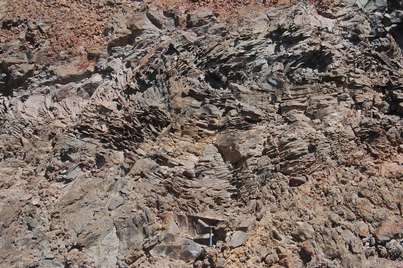
Partway up the grade, there's a good pullout on the left (east, against the cliff face- location). At that spot, there's some terrific platy jointing, with dendrites all over the plates, and vesicular basalt. (There's a hammer for scale at the bottom of the first photo.)
I certainly don't need any more vesicular basalt, but I've never seen platy jointing like this elsewhere, so I added three or four more examples (I have a few from previous trips).

I think I'll wind it up here, for now. As a cliffhanger of sorts, I'll point out that we're only 15 minutes or so from crossing the OR-NV border at this location.

Saturday, December 29, 2018

What a Trip! 2018 Edition (Part One)

I did two geology trips in 2018. The first was with a couple of non-geology friends, in mid-June, up to Quartzville. They had a great time, but I kinda feel as if I've beaten Quartzville to death, and I didn't take any photos (though I did, of course, come home with more rocks), so rather than belaboring it beyond saying we basically followed this guide, that's all I have to say about that.

On the second trip, from September 4 through 9, we hightailed across the Cascades at Willamette Pass (Route 58, from roughly Eugene to Crescent), and made a quick stop at Salt Creek Falls. That waterfall is the second tallest in Oregon, after Multnomah Falls.
I also pointed out the glacial striations on the columnar basalt near the top of the falls.
These two photos weren't from this trip, but from August 8, 2011. The memory chip in my camera was nervously close to full, and the card reader in my laptop stopped working, so I had no way to make more space on it (as far as I knew at the time). As a result, I was more miserly about photos than I might normally have been.

Our first real excursion, after coming down the east side, taking the Crescent Cutoff from Rte 58 to Crescent, then north on Rte 97 to La Pine, then southeast on Rte 31 to Fort Rock Road, and east to Christmas Valley, was at Crack in the Ground. Location here, cross hairs over the parking area.
As you can see in this shot, there's a decent path, with a lot of ups and downs over piles of breakdown. Here, I'm at the top of a "hill." looking down into a "valley" with Hollie and Gary. Crack in the Ground is a weird feature, and unique as far as I know. When I was an undergrad, it was thought that asymmetric subsidence associated with the emptying of the magma chamber that fed the Four Cones Volcanic Field had localized flexure at this location, essentially "hinging" along this line, with the east side down, and the west side remaining at its former elevation. Evidence has popped up (I don't have the source available at this moment) that there is a pre-existing fault under the younger lava flows, so that fault may have provided a weak area that helped localize the flexure more narrowly to this location. The total length of the walk, from the car to the crack, through the most popular segment, and back to the car again, is probably about a mile and a half. The crack totals about six miles long, but much of it is prohibitively rugged for me, with enormous piles of large boulders tumbled one atop the other. This segment, though it has a lot of up-and-down clambering, is pretty easy.
The crack has its own microclimate, cooler and moister than the surrounding arid scrub. I was quite started the first time I encountered stinging nettle there (and a little bit itchy and sore), but I've learned to expect and point it out to others. Also, being cooler, and largely shaded, it can hold winter snow quite a way into summer. There are stories of pre-refrigeration locals coming out here to have ice cream parties into July- a month that would make ice cream an especially welcome treat for a sweltering summer.
Looking up to a juniper on the rim.
And back out again! Looking north from the south end of the easy segment of the crack.
We walked back to the car along the west side of the crack. Looking northeast, you can see that this surface is higher than the ground over there. What you *can't* see is that there's a ~60 foot drop just past that line of sage in the foreground.

From Crack in the Ground, we drove back to Christmas Valley, then followed the Christmas Valley Highway east to Rte 395, where we turned south. Just before that road descends toward Abert Rim, there's a well-maintained gravel road, "The Hogback," that trends southeast into the Warner Valley and the foot of Hart Mountain. As we approached the tiny little town of Plush, we turned north to the BLM Sunstone area, where we spent the night, awed by the utterly perfect skies for star watching.

I've just decided to do this as a series. Given the progress today, I'm doubtful I'm going to get the whole trip written up before Interzone closes on New Year's Eve. Better to publish in dribs and drabs than to having almost nothing for 2018. It'll get finished when it gets finished, but having it incomplete will perhaps motivate me to get it done a bit sooner.

Friday, October 19, 2018

Upper McKenzie River/McKenzie Pass Guide

I promised a friend I would write up a self-guided tour of the area described in the title before this weekend, and if I'm going to get it done, it needs to be now. I don't have mileages, but I can post links that have lat/lon details embedded, and satellite imagery. Oh, and photos, of course. Oh, and links to old posts (maybe).

Before starting: Advice
  • Gas up before you leave Sweet Home (probably cheapest here or out at I-5). There's no gas for most of the trip until near the end.
  • Take food. There's a mom and pop burger joint at Clear Lake Resort, but it may be seasonal; I'm not certain it's open at this point.
  • Take layers and a windbreaker. It'll be a lot chillier at Pass levels, and it's often quite windy, so even if you don't need it, be ready to warm up.
  • I just checked: McKenzie Pass appears to still be open, which I expected, but for future reference, it's often closed at this point. It generally doesn't reopen until sometime in July.
Let's start with the Rte 34 crossing over I-5 as a beginning. Continue east through Lebanon, where 34 is rejoined by Rte 20, then on through Sweet Home. Stay on 20 until you come to McKenzie Junction. From I-5, I'm guessing this is a bit more than an hour, maybe 1:15 or thereabout. At the Junction with 126, there's a good pullout just after the turn. (Crosshairs on pullout here.) Walk back up the grade, west, along 20- there's a wide berm, and a great view of Three Fingered Jack.
Also, at this time of year, the vine maples are flaming red. Very evocative on the recent lava flow.
Speaking of lava flows, this is the first of many recent ones you'll see today. On the drive up from Sweet Home, you've been traveling through Western Cascades Volcanic rocks, which range in age from about 35 million to 5 million years old. Coming down this hill, you crossed from Western Cascades to High Cascades volcanics, which started about 5 million years ago, and continue to present. If I recall correctly, this flow is one of several from the Sand Mountain chain of cinder cones, at about 3000 years ago. More info here.

Head south on 126 to the Fish Lake parking area. Most of the year, this location is a meadow, but during late winter and spring melt and runoff, it fills with water and a native trout that resides in the creek most of the time occupies the lake. As it dries during the summer, they return to the creek. An interpretive sign describes their situation: apparently, they're reproductively isolated, and seem to be in the process of speciation- though that's my inference, and not explicitly stated on the sign.
Continue south, watching for signs to the Clear Lake Resort- it's a turn to the left, and always comes sooner than I expect.
A different lava flow than we saw at the junction blocked the McKenzie River about 3000 years ago. Most of the time, except for occasionally during peak melt-off, the lake is entirely spring fed, with no surface streams running into it. Nevertheless, the McKenzie River drains out of it, full-blown. There's a river's worth of springs under this lake! Also, you can see the trunks of trees drowned when they were inundated 3000 years ago!
Also, weird illusions... is this boat *in* the lake, or floating a few feet above it?
There are something like 18 lakes with the same name in Oregon, but to my mind, there's only one "Clear Lake." Note the drive in and out of the resort is south to north, so you passed the exit getting here, and you'll pass the entrance again once you leave. You have my permission to drive back through again. I mean, who could blame you? Continue south, and turn off (right) in a couple miles to Sahalie Falls.
According to the person who did her doctoral dissertation on the hydrology of this area, little or no water is added to the flow between here and Clear Lake, so this is a dramatic demonstration of just how much spring water flows into the lake.

Continue a few miles south to the Koosah Falls turn off, then drive in a ways to park. This is a frustratingly difficult waterfall to get a good view of, but there is a view area along the southern loop of the footpath.
You can also see the brink from a viewpoint there, but you can't really see the falls themselves. The really interesting thing is all the springs coming out of the walls in the lower gorge.
Continue south on 126 to the junction with McKenzie Highway, 242, and turn east (left). This looks like it's about 14 or 15 miles from Koosah Falls. Head east on 242 to Proxy falls, and park in the pullout on the left. There's a nice ~1 mile loop trail to Lower and upper Proxy Falls. The lower falls are quite spectacular.
The upper falls aren't as grand, but they *do* offer a nice analogy for all the weird water goings-on in this area: They originate as springs above the cliff, fall over it, and the plunge pool sinks right back into the ground. I don't think this "stream" even has a name; it's only a few hundred feet long. Incidentally, this lava flow is from Collier Cone, up near the North Sister, and at only 1600 years old, is the youngest lava flow you'll see today.
Continue the loop back to your vehicle, then continue driving east. You're heading up a glacial valley that was incised into the High Cascades during the last ice age, and the road switches back and forth to climb up the headwall of that valley's cirque. It gets... hairy. Take it slow and easy- the road's in good shape, it's just kinda scary. You can see why they don't maintain it for winter travel, though.

When you come out on top of the plateau, the road straightens out, the trees are much more sparse, and the views open up. This is from the edge of the first lava flow you encounter on the roadside after you're up on the plateau.
It may not look like anything special, but this young volcanic landscape is why there are so many springs: hundreds of inches of snow fall up here every winter. When that snow melts, all the water just runs into the ground, then re-emerges as springs along the Upper McKenzie River. The almost entirely spring-fed nature of that section is also why the water quality is so stunningly high. Continue east toward McKenzie Pass. There are several pull-outs on the right, with nice views of the Sisters.

Then comes McKenzie Pass and the Dee Wright Observatory. This spot is an Oregon Gem, but I'm always surprised how few know of it.
The lower story is enclosed, and each of the windows faces toward a particular volcano. The labels under the windows aren't easy to read in some cases. But the upper story is open, and has a compass rose point out many visible peaks. If you have time and interest the trail out onto the flow has quite a few informative signs.

This is more or less the end, but you have a couple of choices here. First, continue east to Sisters, then Head back to Corvallis over 20 and Santiam Pass- more scenic, but longer. Second, you can turn around and head back on 242 to 126, then follow 126 to Eugene/Springfield, then take I-5 back north to 34. Shorter and quicker, but less scenic. Hope this was fun! Below, geologists in their preferred habitat.

Thursday, September 29, 2016

Geo 902: Jefferson Looms on the Horizon

A last shot from Ochoco State Park: I turned around to face west, and there was a nice view of Mt Jefferson. I promise, it's right there, kinda behind the middle of the three electric poles in the middle of  the photo. It's not the darker, more visible one in the right middle.

I had forgotten Jefferson is the second tallest mountain in Oregon (after Hood). More basic information on the mountain can be found on its USGS page. It's also the Cascade Volcano that's most reliably visible from Marys Peak, and thus the one I've seen most often. I have climbed most of the icefield visible in this photo, but it got steep enough that, without crampons, I decided to stop and turn around.

Photo unmodified. September 7, 2016. ZoomEarth location.

Sunday, September 25, 2016

Geo 900: Ochoco State Park

Looking a bit south of east from Ochoco State Park, we see a variety of rimrock basalts of varying ages. The one on the right has been named the Basalt of Meyers Butte, which has been dated at 5.42 +/- 0.11 Ma, and erupted west of this location. (Glad I looked it up: I had been under the impression these came from Newberry Volcano, which is way to the south.) This PDF (see page 4) has a very similar photo to the one above, with the various basalt units labeled, and a field guide going into great depth about the volcanic stratigraphy of the area.

There are numerous reasons I wouldn't live in eastern Oregon, but the views and excellent, less weathered rock exposures make it a favorite place to visit.

Photo unmodified. September 7, 2016. ZoomEarth location.

Saturday, September 24, 2016

Geo 899: Three Fingered Jack and Cascade Crest

I've been trying to find a name for the peak on the left-middle skyline; at 6200 feet plus, it must have a name. However, I've been unsuccessful. The rubbley and shaded area on the left is the quarry northeast of, and the base of, Hogg Rock, and TFJ is the peak on the right. My sense, when I was there, was that we were looking at the transition between an icefield and a valley glacier in terms of the valley landforms, and the Google topo map below seems to support that somewhat. The black dot is the approximate location where the above panorama was taken. The patch of blue on the map's lower left edge, above Route 20, is the east end of Lost Lake.
Directly south of Hogg Rock, and not pictured, is Hayrick Butte, another tuya, and Hoodoo Butte, a post-glacial cinder cone, and the closest ski area to the mid-valley region.

Panorama stitched in Hugin. Photos unmodified. September 7, 2016. ZoomEarth location.

Friday, September 23, 2016

Geo 898: Three Fingered Jack

From a quarry on the north side of Hogg Rock, the view to Three Fingered Jack is excellent. Three Fingered Jack is described on OSU's Volcano World page as a stratovolcano in the leading basic information, then in the first sentence as "a deeply eroded basaltic shield volcano." I don't know which it is, but I guess I'd lean toward shield rather than stratovolcano. The Oregon Cascades were heavily glaciated during the Pleistocene, and the fact the volcano is so deeply incised shows that it hasn't been active- or at least hasn't had any major lava-producing eruptions- since the end of the ice age. Mt. Jefferson, the next major peak north of it, shows the same style of faceted glacial erosion.

Route 20 winds around the west and south side of Hogg Rock, a tuya (a sub-glacial eruptive landform, where the lava erupted under ice), much too close to get any decent photos, and the rock here in the quarry seemed too nondescript to bother with. The best photo of Hogg Rock on this trip was the one I took at Lost Lake. As noted in the post at that link, the pass area burned a few years ago, killing many, many trees.

Photo unmodified. September 7, 2016. ZoomEarth location.

Thursday, September 22, 2016

Geo 897: A Last Glance at the Lost Lake Drain Hole

I'd say the hole is about 4-5 feet across, less than the 6 foot diameter reported in most of the stories I've read, and 2-3 feet deep. As I mentioned in the first post about this location, the layers of ash and lapilli are probably responsible for creating a tough and poorly permeable lake bed. It does seem likely to me that this is some kind of sinkhole, but I don't have any sense of what might have created the void that the rock collapsed into. The mafic lava flows in the area have enormous amounts of void space in their rubbly surfaces, and I don't feel that a lava tube is a necessary conclusion, though it might be the correct one. Perhaps someday we'll find out.

To put this in a broader context, if you're traveling across Santiam Pass, and you have a little time, this is well worth the rugged, pot-holey drive in (I'd say okay for smaller cars, just take it slow.) at least once. It's not something I'm going to feel I need to do every summer, but I'd like to visit in the late spring sometime, and given the new hole, it might be worth stopping every few years or so, to see if the area evolves further.

Photo unmodified. September 7, 2016. ZoomEarth location.

Friday, September 16, 2016

Geo 892: Lost Lake's "Drain Hole"

The hole is both smaller and shallower than I expected, and at this time of year, well back from the water's edge. The lake bed appears to be composed of relatively thin laminae of ash and lapilli, and well lithified. This isn't surprising, given its location near the crest of the active section of the Cascades, but it isn't what I was expecting. Rubbly basalt and basaltic andesite dominate much of the central Oregon Cascades between our location here, along Highway 20, and McKenzie Pass along Rte. 242. However, my suspicion is that under these layers of tephra, the lava rubble is present; that would allow the water draining through this sinkhole to move to the water table, and, ultimately, re-emerge at Clear Lake.

Photo unmodified. September 7, 2016. ZoomEarth location. (Location approximate- can't resolve hole.)

Thursday, September 15, 2016

Geo 891: Lost Lake Basin and Hogg Rock

The basin the the foreground fills with water during late winter into spring, then slowly drains into the ground over the summer- there is no surface outlet. I've thought for years that Hogg Rock, in the back, looked like a tuya- a subglacial volcanic landform- in terms of its shape, and a couple months ago, I was informed by Adam Kent, a volcanologist at Oregon State, that it is.

Over the past year, there have been a number of stories in Oregon news sources about Lost Lake's "drain hole," starting with one in the Bend Bulletin. Even though I had never stopped here before, I was able to get a general sense of its location from the shape of the landscape in photos accompanying the articles. However Hollie and Gary had visited the site previously, so we didn't have to search it out. Nevertheless, my "general sense" turned out to be quite accurate. We're looking pretty much right at it, but from this angle, it's hidden in the grass and willows.

The countless dead trees on and around Hogg Rock were killed in a nasty fire a few years ago.

Photo unmodified. September 7, 2016. ZoomEarth location.

Wednesday, May 27, 2015

Geo 1095: May 27, Day 877: Simple Contact, or Channel?

Down in those vine maples, you can see the contact between the edge of the Collier Cone Lava Flow (right) and the older, glacially carved, volcanic rock of the valley floor (left). The question is, has this contact been modified by rare to occasional burst floods from above the valley? It seems clear to me that there has been no such activity recently; the thick-bedded moss would not be so consistent. Likewise, there's some down logs in pretty advanced states of decay near the center of the photo. Any recent (past decade or so) would have left both of those features more chewed up. The contact seems rounded, which might indicate erosional modification... but look at all that living and dead plant material! Surely that might be the explanation for the apparent rounding.

In the end, as is so often the case, the answer is, "I don't know; I need more information." I'm okay with that. It means I have a reason to go look again.

Photo unmodified. October 9, 2014. FlashEarth location.

Tuesday, May 26, 2015

Geo 1095: May 26, Day 876: Upper Proxy Notch

Looking back down the path from Upper Proxy Falls (i.e., the falls are behind us in this view), The Collier Flow is on the right, and the southern edge of the valley is on the left. Has this notch been reworked by running water? It's not clear, but it seems possible. It would certainly fit with the idea of burst floods contributing soil components (clastic sediment and plant debris) to the surface of the lava flow, and fostering an environment for rapid recolonization and reforestation. I have a few more photos of this notch, and I'll post at least one more, but looking over them, I see nothing convincing either way. Next time I get back here, I should see if I can spot rounded gravel farther down the notch- it drops quickly just past that saddle.

Photo unmodified. October 9, 2014. FlashEarth location.

Monday, May 25, 2015

Geo 1095: May 25, Day 875: Collier Flow Berm

My camera's flash has a tendency to go off at times I think it's unnecessary, but it can lead to some interesting shots, such as this one. One has to clamber over the root system of this Doug fir to get at the rubbly hillside- the south edge of the Collier Cone Lava Flow- where you can see Anne and Chris in the upper left corner. It might be interesting to come up here with a couple bottles of food coloring to see if you can actually find the area(s) where the water is leaving the pool. It's shallow, and the volume is fairly small compared to the rate of flow from Upper Proxy Falls into it, so I'd bet the residence time of water in this pool is in the range of ten minutes or less.

Photo unmodified. July 6, 2013. FlashEarth location.

Geo 1095: May 24, Day 874: Upper Proxy Runout

Sitting up on the berm of the Collier Cone Lava Flow, looking down to the runout of Upper Proxy Falls is a peaceful experience. I love the little Doug fir that has managed to get established on a tiny island in the pool... I think I'll call it The Little Prince. As I mentioned in the previous post, this pool has no outlet. However, looking at the shape of the gap between this little cove and the lower valley, where the trail leads to this spot, I'm pretty confident this stream does overflow its basin from time to time. This may be related to the burst floods that (rarely) make it into channels up on the flow behind us here.

Photo unmodified. July 6, 2013. FlashEarth location.

Saturday, May 23, 2015

Geo 1095: May 23, Day 873: Upper Proxy Plunge Pool

This is far from an ideal panorama; the left photo has too much motion blur, the center one is fine, and the right photo is overexposed in comparison to the other two. Nevertheless, it's the best I have to capture the "rather unique twist" I mentioned in yesterday's post. That photo was facing toward the falls; this one is taken standing a bit to the west, looking back toward the base of the falls. You can see the run-out coming in from the right side, flowing into the pool at the base. Given the amount of talus and downed logs at the bottom of the falls, this isn't technically a "plunge pool," but for the title, I liked the alliteration. The trees and their roots on the left pretty well obscure the fact that the slope there is the southern margin of the Collier Cone Lava Flow. Can you spot what's missing?

There's no outlet to this pool. This stream emerges from springs at the top of the glacially-carved valley, tumbles off the edge as a hanging valley waterfall, then promptly goes right back underground, into the side of the lava flow. Neato!

Photo stitched in HugIn, otherwise unmodified. July 6, 2013. FlashEarth location.

Friday, May 22, 2015

Geo 1095: May 22, Day 872: Upper Proxy Falls

Upper Proxy Falls is smaller than Lower Proxy (shown in yesterday's post), both in terms of height, about a hundred feet shorter, and flow rate. This one appears to be two streams converging in a waterfall, while the other appears to be a single stream splitting in a fall; in that sense, they're kind of opposites of each other. This one, though, has a rather unique twist to it, which I'll get to tomorrow.

Photo stitched in HugIn, otherwise unmodified. October 9, 2014. FlashEarth location.

Thursday, May 21, 2015

Geo 1095: May 21, Day 871: Lower Proxy Falls

This is actually a single photo, which I don't think is as good as the very similar-looking panorama I posted shortly after our visit last October. Comparing the two, I think the higher top of this one includes brighter light, and it looks as if that has caused the entire photo to have poorer saturation than the panorama. However, for the sake of completeness during this segment, I'm including another shot of Lower Proxy Falls, which, on our trip with Anne the previous summer, we skipped. It probably wasn't really necessary to skip it; this waterfall is no more than a hundred yards from the junction, so to this viewpoint, it's an easy walk. Dana and B. walked down to near the base, but as is often the case with me in recent years, I didn't want to earn "back uphill" points. I just sat here until they came back up the hill, dazed by the beauty of this spot.

Photo unmodified. October 9, 2014. FlashEarth location.

Wednesday, May 20, 2015

Geo 1095: May 20, Day 870: Hard Evidence

Can you spot the hard (pardon the pun) evidence of running water in this photo? And we're not talking about a minor trickle, but a fairly competent flow. If not, take a look at the crop below. The Douglas fir cones scattered around are typically 2-3 inches long, for a sense of scale.
Look how rounded that gravel is! This is very clearly not simply a lava gutter, though it may have started out as one. I don't know if water has ever been actually witnessed flowing through this channel, but clearly it has at some point. Eyeballing the woody debris, and its generally not-too-decomposed state, I'd bet it hasn't been very long, maybe in the range of a decade or so. During the winter season, the road to this trail is closed. People do visit during the winter season, but it's a fair trek in from the gate (~7 miles round trip), so the number is limited. Take into account that the kind of weather that I'd guess is responsible for burst floods that might behave like this is heavy warm rain on a heavy snow pack, it seems likely that even those venturous folk might hesitate to visit on days when this might happen.

Photo unmodified. October 9, 2014. FlashEarth location.