Our trusty vehicle got a flat, apparently on the rugged and rocky road on the way into the sunstone area (
Incidentally, location here), so Gary ended up spending an hour or more getting that monster changed. The sun was already low, and getting ourselves set up was the first order of business. I didn't end up spending much time looking for the namesake mineral in the area, which is a specific type of labradorite feldspar. I did find a few, but the camping area has been improved quite a bit, which means more people near the vault toilet, which in turn means this central area is pretty thoroughly picked over. There are picnic benches with shade shelters. I don't think I've ever been here in real summer weather, but those shelters must be very nice in the heat. Also, there's a nice pad associated with each shelter, for tents.

Looking roughly south, toward the Rabbit Hills, with our table and shelter on the right. Given that we were *not* going to continue the trip without a functional spare, our first order of business on Wednesday was an unplanned detour into Lakeview to get the flat repaired. However, my goal for this trip was to get a nice sample of the basalt that hosts, then ultimately weathers to yield the sunstones- sunstones in situ, if you will. If you head south from the toilet, there's a bit of a dry wash, where mostly fresh basalt can be found easily. Below, looking north, you can see the toilet in the upper right, and some samples (I think I only kept one) on the lower left.
After the quick gallop down the gully, we packed up the last of our things, drove an hour and some to Lakeview and the local Les Schwab. If you buy your tires from that company, they do repairs for free. Then we drove an hour and some *back* to Warner Valley, and up Hart Mountain.
I've stopped at the switchback about 1/3 to 1/2 the way up the mountain a number of times; there's a great view of the shoreline from the pluvial lake that filled Warner Valley during the Pleistocene. (
Location here.)
There's a new-to-me interpretive trail, with a nice little parking area at the site. I didn't learn much from it, but I've stopped at this location quite a number times, and pretty well already understood what I was seeing. It's a fairly easy (though rocky) trail, and recommended for folks who are new to the area. Here's Hollie looking out over the pluvial lake remnants, stabilized dunes, and pluvial shorelines on the opposite side of the valley. (The latter shorelines were easily visible to the eye, but the hazy smoke is apparently less penetrable to the camera.)
The water body closest to the viewer here is Upper Campbell Lake. The one farther out is Flagstaff Lake, which, according to National Geographic, is the farthest one can get from Interstate Freeways in the Continental US. It's a
*very* remote area.
Another new-to-me feature at Hart Mountain is a spiffy wall around the Hart Mountain Hot Spring. My first assumption was that it's for privacy- whatever the actual rules may be, this is a de facto "clothing optional" spot. However, it may serve primarily as a windbreak. It can get very windy up on the mountain top.
(Location)
The spring itself is quite pretty, but not terribly hot, more like a comfortably warm bath. It's also not terribly big; I figure after about 6-8 people, it would start to feel pretty crowded.
Looking roughly southwest from the hot spring, there's an area of patchy sinter, and some "warm puddles," suggesting there's an underlying fault controlling the groundwater flow.
From the spring, we headed back down the mountain, through Plush, then south to Adel, where we turned east on Rte 140. Within 30 minutes or so, we were cruising across Guano Valley, admiring the daunting Doherty Grade, where 140 turns sharply south, and climbs diagonally up the side of a cliff. It's kinda scary the first time, but the road is well-engineered, and wider than it feels. I think it's the lack of guard rails that feels so unsettling. In the following photo, the road is visible as a dim gray line against the dark mafic volcanic rock. (Photo taken August 19, 2011)
Approximate location
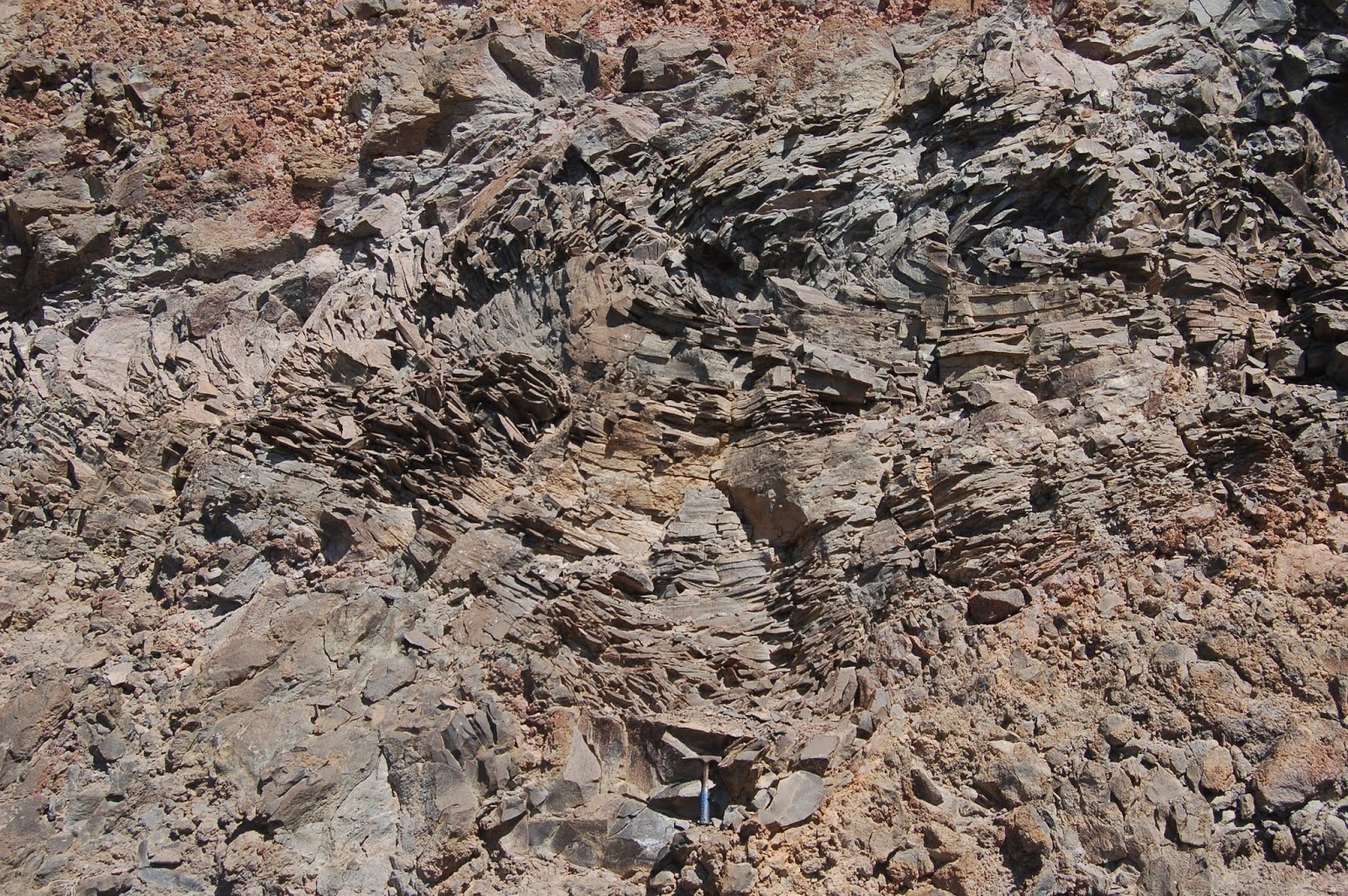
Partway up the grade, there's a good pullout on the left (
east, against the cliff face- location). At that spot, there's some terrific platy jointing, with dendrites all over the plates, and vesicular basalt. (There's a hammer for scale at the bottom of the first photo.)
I certainly don't need any more vesicular basalt, but I've never seen platy jointing like this elsewhere, so I added three or four more examples (I have a few from previous trips).
I think I'll wind it up here, for now. As a cliffhanger of sorts, I'll point out that we're only 15 minutes or so from crossing the OR-NV border at this location.


2 comments:
Nice post! Definitely let us know when that photography account exists!
Yo lockwood its scott. Have no idea how to get ahold of you but i made it down to az by way of steens..nevada..utah..nm... trip we talked about. Tha ks for all your recommendations it was a great trip
Post a Comment