Saturday, August 23, 2014

Geo 730: August 23, Day 600: Boulder Creek Boulder

Boulder Creek is a tributary to Quartzville Creek, just a bit upstream from the quarry. I don't have any photos of "the pyrite stop" (Yes, another one) up the road there, but I'll post a link to a nice 360 by 360 panorama sooner or later. I've always presumed Boulder Creek was named for this giant block at the confluence, and no one has ever told me differently. It's not easy to get a sense of scale here, but I'd estimate those two tree trunks to the boulder's lower left are in the range of 18-24 inches. The rock is humongous. That actually presents a bit of a problem; at that size, it's not readily apparent how it could have been transported at all, let alone without getting smashed into flinders. My best guess is that it was entrained into a debris flow up the tributary sometime over the last few hundred to thousand years. This would have provided both a transporting agent and cushioning from crushing impacts. And my guess about the timing would provide enough time for floods and steady erosion to remove most of the smaller fragments associated with that hypothetical debris flow. If you look just a bit to the right of the cross hairs, across the creek from the road, in the FlashEarth view, this behemoth is readily visible.

Photo unaltered. July 7, 2012. FlashEarth Location.

Friday, August 22, 2014

Geo 730: August 22, Day 599: A Parting Shot

I mentioned yesterday I wasn't sure if I had decent photo of the tourmaline at this spot. This isn't great, but if you enlarge the photo to full size and look at the darker areas below and to the left of the hammer's chisel tip, you can see acicular (needle-like) black crystals. That's tourmaline. Definitely not jewelry quality. And course, plenty of pyrite and possibly other sulphides shot through the rock. I have rarely seen galena and sphalerite at Quartzville, but the only sulphide I've been able to identify with full confidence at this quarry is pyrite.

Photo unaltered. June 14, 2014. FlashEarth Location.

So You're Going to Bend...

What to do, what to do? The area has a lot of options for people interested in geology, though some require a bit of a drive. In the city itself, Pilot Butte has great views of Bend and the surrounding landscape- in particular, west to the Cascades and south to Newberry. There is a trail to the top, though I can't imagine it's very interesting compared to others in the area, but there's a paved road to the top too, with ample parking. The last time I was there was at sunset, and the glare to the west made it impossible to see the Cascades well. I'd bet it's spectacular at sunrise, and mornings generally are probably better.
Pilot Butte, from Geo 365. (See the Index for more photos and information)

Newberry... *SO* much to do and see. A large portion of this complex was set aside as Newberry Volcano National Monument in 1990. (See up-to date info on fire closures and other alerts, as well as general and contact information at that link) Here are some highlights:

*Lava River Cave- I haven't been to this feature in years, but it's Oregon's longest known lava tube, at a bit over a mile. There's a per-vehicle fee, but I don't know if that's in addition to the general entry fee for the monument (I kinda doubt it, but I'm not sure). Then there's a rental fee for propane lanterns, but that's like a couple bucks and is trivial compared to the value of exploring the cave. The cave itself is a refreshing brisk walk on a hot summer day- a nice escape from a hot summer afternoon, the average temperature is 42 degrees- you'll want a jacket or something fairly heavy and warm.
*Lava Lands Visitor Center- I don't find the visitor center itself all *that* interesting (others less familiar with the area may disagree) but it's an ideal site to get up close and personal with some typical features of the monument. I'd recommend early in the day for this spot. One can drive to the top of Lava Butte, but parking is limited. The center gives free half-hour passes for parking on a first come-first served basis, but on busy summer days, they can go fast. They open at 9 AM. I'd imagine half an hour is plenty of time to walk the loop trail around the summit crater and take in the views.
Lava Butte summit, looking toward Newberry, from Geo 365. (See the Index for more photos and information)

Also at the visitor center, "The Trail of the Molten Land" may have a corny name, but it does show some very cool features of a "breach flow" (my term, don't know if used generally) from a cinder cone.
Lava Balls on The Trail of the Molten Land, from Geo 365. (See the Index for more photos and information)

*Lava Cast Forest- Again, a spot I haven't visited in 15 or 20 years, and a bit out of the way (which means it's not as busy), on a heavily washboarded road. This is exactly what it sounds like: a forest was inundated by lava, and the trees are "preserved" as casts. In other words, they're not there at all, but the space they occupied is represented as void spaces. It's worth it if you have the time.

*Newberry Caldera- I suppose if I had to pick just one thing to see in the Bend area, this would be it, though McKenzie Pass is a barely marginal second. Paulina Peak must be one of the most sublime but poorly known vistas in Oregon. The road is rough, narrow, and steep but doable in a sedan... not easy, but doable. For the adventuresome, there is a trail from the caldera floor to the top of the peak, but with a 1620 foot elevation gain, I'm no longer that adventuresome.
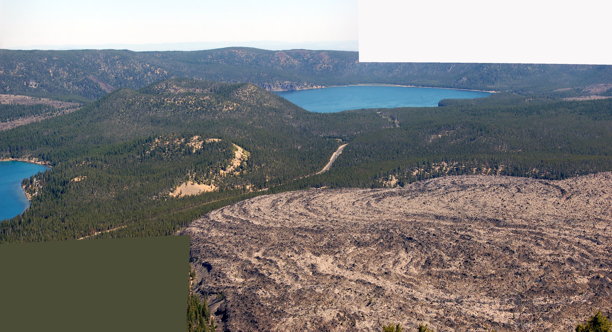
Looking into Newberry Caldera from Paulina Peak. Big Obsidian flow lower right, from Geo 365. (See the Index for more photos and information)

More my speed is the roughly one mile Big Obsidian Flow trail, highlighting the features of a stunningly stark pile of broken glass.
Big Obsidian Flow with Paulina Peak in the distance, from Geo 365. (See the Index for more photos and information)

Another spot here, which I haven't visited, but has been recommended to me, is Paulina Creek Falls. I suspect if you choose one of the easier hikes at that link, everything I've listed so far would make a good day (But not if you choose to hike Paulina Peak). However, I've barely scratched the surface in terms of hiking opportunities, focusing more on sights and places I've visited.

Two places I haven't been, but do want to visit sometime, are Cove Palisades State Park, and Smith Rocks State Park. However, the person I know who is actually visiting Bend is planning on some climbing at Smith Rocks, so he probably knows more about that park than I do.

The Headwaters of the Metolius (Wikipedia link, but unfortunately the best link I could find) is a ways west of Sisters, north of Black Butte (The turn-off is just west after you pass the base of this large cinder cone) and it's quite nice, but you're fenced into a relatively small area surrounded by private land, so you can't see much or well. It's frustrating. But this hike looks easy and fun, and a good way to get to know the river better. (I haven't done it, but I should- four miles round trip, fairly flat, I could manage pretty well, I think.)

Finally, as I mentioned earlier, Newberry Caldera just barely squeaks by McKenzie Pass as the number one must-see attraction in the Bend area. Metolius Springs and McKenzie Pass would be an easy, actually, fairly short, day out of Bend, leaving plenty of time for hiking in the Pass area. It looks like Yapoah Crater is a reasonable day hike, if you go after the snow melts back. And I've heard good things about Obsidian Falls. However, I haven't hiked much off-road in this area, so you'll want to track down more information. I found the relatively short (maybe a mile) interpretive trail just to the east of  the observatory to be well done and informative.
"Geobloggers in their natural habitat:" Yours Truly, Anne Jefferson, Chris Rowan and Dana Hunter at Dee Wright Volcano Observatory, McKenzie Pass. (See the Index for more photos and information, and this week in particular has some nice panoramas from the same location. Just ignore July 11 and 13.)

Thursday, August 21, 2014

Geo 730: August 21, Day 598: Spotting Our Quarry

Another view of the back wall of the Quartzville Road quarry, showing the horizontal columns that allow us to infer a dike cutting through. And my presumption, which is quite tentative, is that the lighter areas are less weathered and stained, suggesting that the dike is rhyolitic in composition. And it's the altered rhyolite that shows the most interesting minerals. I'm not sure I have a decent photo of it, but you can also find very fine black tourmaline crystals here, which suggests a high temperature during mineralization.

Photo unaltered. July 9, 2012. FlashEarth Location.

Wednesday, August 20, 2014

Geo 730: August 20, Day 597: Altered Andesite?

For reasons I explained earlier, I'm pretty uncertain with respect to the actual field relationships in this quarry, but the gray rock occupying the center of this photo appears to be the host rock into which the rhyolite intruded. It's some kind of altered intermediate volcanic rock (for example, andesite), but it doesn't seem to be as altered as the lighter rhyolite. It's definitely not mineralized with sulfides in a similar manner. As an aside, the pervasive iron staining on the surrounding blocks is due to chemical weathering of the pyrite in the rhyolite, and a close inspection of those surfaces will often reveal small cube-shaped pits where that mineral has weathered out.

Honestly though, the reason for this shot is that I love the moss colonizing what has to be a hostile, barren surface, utterly bone dry for several months each year, and buried in snow for the bulk of the remaining months. (Probably mostly snow covered ~October to ~April)

Photo unaltered. July 9, 2012. FlashEarth Location.

Tuesday, August 19, 2014

Geo 730: August 19, Day 596: Pyrite Patch

I *think* this is the same patch of pyrite as seen in yesterday's photo, but from more of a head-on perspective. The rock here is tough, and highly silicified. For the most part I tend to pull out "the heavy artillery," that is, a sledge hammer, for this stop (in the top right, a four pound hand sledge). It's definitely a spot for eye protection, and even with that, flying splinters can draw blood. But kids loved it; it was obvious they were willing to risk an owie and a Band-Aid for a piece of pyrite. Again, if you look carefully at the full-size image, you can spot flecks of the sulfide throughout the rock, and along the upper left quadrant of the lens cap, there is some color that I'm suspicious is slightly weathered chalcopyrite.

Photo unaltered. August 5, 2012. FlashEarth Location.

Monday, August 18, 2014

Geo 730: August 18, Day 595: We're Golden

In the lower right, you can see the draw of this quarry for kids in particular, but adults as well. Pyrite (and perhaps small amounts of chalcopyrite, too) are disseminated throughout much of the rock, but can form nice patches, as well as aggregations of small cubes, along joints and fractures. If you look carefully, especially at the photo in full size, you'll spot pyrite across this entire surface. The evidence for chalcopyrite is that on slightly weathered surfaces one can often spot iridescent colors- purples, reds, greens, blues- which I've associated with copper sulfides, but not plain iron sulfides. I haven't seen anything as colorful as bornite, though. If there is actually any copper here, its concentration is low. On the other hand, a doctoral dissertation (3.7 MB PDF) completed when my interest in the area was intensifying suggests that this area is underlain by a copper porphyry deposit. So the fact that there may be some copper in the sulfides here wouldn't be a shock.

Photo unaltered. August 5, 2012. FlashEarth Location.

Sunday, August 17, 2014

Geo 730: August 17, Day 594: Altered Rhyolite Dike (?)

By this point of the Quartzville trip, the rocks are getting consistently weird. Above is a case in point. In this (perhaps temporarily) disused quarry, it looks as if the target rock was hydrothermally altered rhyolite, and it looks as if the rhyolite occurs in a dike, seen as horizontally jointed columns toward the back. The reason for the tentative "looks," though, is twofold. First, ALL the rock is so cooked and altered that it's difficult to tell with certainty what the protolith was, and it's difficult to tell one rock type from another without splitting open a fresh surface. Even then, guessing what the rock is, and what it was, is exactly that: guessing. Second, see that pile of talus? That's probably why this quarry is disused: it should have been developed with terraces/benches, rather than sheer vertical walls. Stuff falls off those walls frequently, especially during the spring and fall. When I took students up here, I restricted them to the very base of the talus piles, and preferably to the loose rubble out away from the base. I also kept a very close eye on enforcing that rule. Why? *I* won't go up those piles myself. The rock falls are too unpredictable and too dangerous. As a result of that second problem, I've never laid hand on in-place bedrock here, only speculated from a distance.

Photo unaltered. August 5, 2012. FlashEarth Location.

Geo 730: August 16, Day 593: Charcoal-Grilled Strawberries

Well, at least the plant at my fingertip looks like a wild strawberry to me. Though it's not really grilling, and that's not really charcoal. Pretty much all the rock visible in this photo is ancient charcoal, completely infused and filled with quartz. This is at the east/upstream end of the outcrop, where the base of the "wood" containing breccia-like rock comes down to near the road level, (Dip is to the east here.) and it's actually reachable. Elsewhere, you can't get at the apparently obliterated forest, but the black chunks are large and contrasty enough that you can see them easily from the road.

Photo unaltered. August 5, 2012. FlashEarth Location.

Geo 730: August 15, Day 592: Plants, Old and New

The new plants are pretty obvious, though browning in the early August heat. The old "plant" is not so obvious, but easy to spot once you know what to look for. See the black splotch in the bedrock, occupying the central portion of the photo? That's a large block of what seems to be permineralized charcoal. About a month ago, I posted a microscopic view of this material. It's weird stuff. The carbon in the charcoal is preserved, unmodified, but all the pore space has been filled with quartz. As a result, the charcoal exposed at the surface will smudge your fingers, but the rock as a whole is hard enough to scratch steel.

Unfortunately, I only have two photos of this terrific outcrop. I think there are two major issues: I've done this trip close to fifty times, so it's all deeply familiar to me. I simply don't think about the necessity of having illustrations for people who *haven't* been here. Also, this is a long, tiring day, and often when I'm tired, I'm just operating on autopilot... I'm not even thinking abut thinking. At any rate, I'll just describe it verbally. At the base of the exposure is lahar deposits, based on the angular nature of the clasts, their volcaniclastic composition, and their extremely poor sorting. There may be a second lahar over the oldest exposed, but the outcrop is weathered enough now that I can't see the possible contact I thought I had identified many years ago. Over that is a clearly water-transported and sorted sandstone, which is a ledge-forming bed about a foot thick. Rarely, you can find permineralized, horizontally oriented, woody fossils, which I take to be roots. Above the sandstone is a thin layer of siltstone, which, if and when you can find it, has abundant plant fossils: leaves that look like alder, some sort of coniferous needles, sticks and twigs, and (very) rarely, seeds, cones and catkins. On top of the silty layer is a ruddy layer that I think is a paleosol, a few inches thick. Above all that, finally, is the rubbly layer containing the charcoal. The cobbles are poorly sorted, but seem better rounded. I'm not sure how to interpret the rock, but I'm suspicious I'm seeing sphereoidal weathering, not transport-related rounding. The blocks of charcoal look as if they're entire tree trunks, and their size- up to several feet in diameter- is consistent with that. For more photos, see Dana's posts, a geologic riddle, and with a better overview of the outcrop, the follow-up answer.

Photo unaltered. August 5, 2012. FlashEarth Location.