Saturday, October 6, 2012

Ponderosa!

In a post yesterday, I didn't state it explicitly, but the general transition from rainy western Oregon- west of the Cascade crest- to dry eastern Oregon is most easily noted in changes in the dominant trees in the area. At the crest, the dominant tree is Douglas fir (which isn't a true fir, and leads me on occasion to be confused about exactly how that name should be spelled). As you descend onto the East Side Apron, you generally encounter an interval dominated by ponderosa pine (though as I mentioned in yesterday's post, it's not well represented along Route 58), the central topic of this post. Out into the drier eastern foothills of the Cascades, wooded areas are dominated by lodgepole pine, much shorter, more spindly, and evolved to be burnt off once or twice a century. Still drier, and you lose trees almost entirely, and move into grasslands and sagebrush, with the occasional juniper sentinel. To a first time visitor, these transitions, especially as rapidly as they occur in central Oregon, are quite stunning. To one who's made that trip countless times, as I have, it's nice to be reminded from time to time just how unusual the experience is- though frankly, I've done those trips mostly with others, for the very purpose of showing them just these sorts of things, notably the geology and how it affects everything around it, so I don't really need to be reminded.

I live in sort of a boundary area between Douglas fir temperate rain forest and the oak-grassland savannah of the Willamette Valley floor, so Doug fir forests, while they can be spectacular (and good old-growth forest trees can impose a kind of holy awe, like walking into a cathedral) are kind of old hat. I don't care much for lodgepole pine forests. The High Desert has a certain magic, but they can leave one feeling exposed and vulnerable. The best way to explain it is that I love the desert, but like big cities, in limited doses: no more than a week or so at a time.

But I can't get enough of ponderosa pine forests. The crackle-cookie appearance of the bark. The open, sparsely vegetated forest floor. The consistent size and heights of the stems- like columns in classic architecture. Stick your nose up to the trunk and inhale... smell the butterscotch? Some say vanilla, some say it varies from tree to tree, and some, sadly, don't seem to perceive an odor. But it's there, and it smells sweet, like cookies or candy. The deep duff of needles, muffling sounds, softening your footsteps.

There's no doubt, a ponderosa forest is nothing short of magical.

On our trip last summer, Dana, Intrepid Companion and I stopped and visited a very special ponderosa pine, near the aptly named town of LaPine, in central Oregon, at the equally aptly named LaPine State Park. I daresay the title of this post says enough, but despite the risk of being repetitious, I'll say it again: this is not a ponderosa, it's a Ponderosa!
 Yes, it is. A very big tree.
 This is another one of those situations where photos don't help you get a sense of scale.
 And a fence- quite reasonably- keeps visitors from sniffing this particular individual.
 The numbers are pretty damned impressive too.
Standing near the bank of the Deschutes River, looking back.

More numbers. It's hard to imagine this tree being substantially taller, but apparently it was not too long ago.
 Finally, A couple views over and along the Deschutes River...
LaPine State Park has a decent campground, typically isn't as crazy busy as campgrounds in Newberry Volcanic Monument- which isn't exactly "across the street," but is still only a short drive from here, probably about half an hour or less. And this Ponderosa! is a must-see giant among trees.

Followup: I was looking around the FlashEarth link after I finished this post... you might have noticed there's a very nice oxbow just to the east/downstream of the Big Tree. But the river gets very confused just a bit more down stream. Interesting to consider how this thing will eventually sort itself out.

Saturd80's: Hooking Up in Motels Edition

Three songs from The Motel's spring, 1982, release, "All 4 One." Between this and Missing Persons' EP, this was the backbone of the music I listened to during an idyllic Oregon summer in 1982. Only the Lonely

Suddenly, Last Summer

Take the L

Friday, October 5, 2012

Vegetation Gradient

Related to my previous post, on the topic of Oregon's wildly variable rainfall, @JacquelynGill tweeted yesterday, "Do any of you have a nice photograph of a vegetation gradient I could use for a lecture?" I replied "I could send along a few photos of gradient from Cascade Crest into central OR, if interested?" She replied "Yes please!" and after getting her email, I assembled and shot off the following. I have posted some of these photos here before, from my trip to southeast and central Oregon in August of 2011 with Dana Hunter and Intrepid Companion, but you don't mind, right?

Links go to FlashEarth permalinks, which  should give you nice, accurate location info. The Ponderosa Pine stretch is not very well represented along highway 58, and not at all in my photos, so I've included a few farther out into central Oregon. However, it's pretty amazing how many diverse habitats fit well within this particular range. (With exception of photo near Klamath Lake)
 DSC0010
DSC0011
Forest at Salt Creek Falls, Oregon (DSC0010) and Salt Creek Falls (DSC 0011) - Just west of Willamette Pass, guestimate this area gets ~125-150 inches of liquid equivalent precipitation per year, much in the form of snow.
DSC0025
Diamond Peak Veiwpoint, (DSC0025) Forest and Meadow- Very close to crest now, (drag just a bit east and you'll see the Willamette Pass Ski Area, which sits right on the divide) lots of heavy snow. Doug Fir still dominant, but not as big, has a harder time colonizing as shown by meadow.
DSC0030
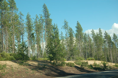
Coming down the east side from the pass (DSC0030), FE location is approximate. Pass is 5128 feet, sign on left side of road notes 5000 foot elevation. Still Douglas Firs, but definitely smaller and more spindly, and undergrowth is not as lush.
 DSC0035
 DSC0036
DSC0042
Looking back toward Cascade Crest (DSC0036), Odell Butte cut off on right side of photo. Lodgepole pine dominant, underbrush mostly grasses and very scrubby. Better view of vegetation (DSC0042). Yellow-tan layer is Mazama tephra. (and added in a followup email, "Actually meant to include DSC0035 as well- 'Yellow-tan layer is Mazama tephra' doesn't make much sense without it.")
DSC0046
Near Klamath Lake (DSC0046) (FE location approximate).
DSC0417
Fort Rock, Oregon (DSC0417) - no trees at all. Grasses, sage brush and rabbit brush (Forgot to mention it in my note, but again, rough guestimate, I'd say in the range of 15-20 inches of precipitation annually in this area... Hmm. Just Googled it and found this: "The mean annual precipitation is 200 to 300 mm," so closer to 8 to 12 inches annually.)
 DSC0425
 DSC0433
DSC0436
Forest near Hole-in-the-Ground, Oregon (DSC0436)- this spot is about 1000 feet- maybe less- higher than Fort Rock, but gets enough more precip to support a nice ponderosa pine forest. And finally, forgot about this one, also at Hole-in-the-Ground (DSC0433). This is the south end of this maar, where the angle of the wall and shade mean water doesn't evaporate as fast, so the pines can at least germinate and grow, if not exactly thrive. In north side of crater, trees don't do well at all (DSC0425)
So there you have it. As I commented in my previous post, "...even if you know nothing about the rocks, even if you know nothing about what types are around, or what processes formed them and put them where they are, the simple fact of two enormous piles of them in parallel north-south ridges have a profound effect on us here in western Oregon." There's no better way to appreciate this than to drive across the Cascades and out just a little way into the High Desert. I've read it's one of the fastest ecological gradients in the world. I'm always skeptical of any source that claims world's most extreme anything, and I won't vouch for that claim. Nevertheless, it's pretty danged impressive to drive in an hour or so from an area that gets well over a hundred inches of rain a year to an area that gets a tenth of that.

(And yes, of course, anyone who wants to use these for educational purposes is welcome to. I'm not sure how much size & resolution they lose being posted to and downloaded from Blogger, but if you'd like full size photos (2000 by 3000 pixels), drop me an email)

OMN Willamette Valley Geology Presentation Part Five: Silver Falls

This is the final portion of the spoken presentation that I gave about three weeks ago for the Oregon Master Naturalist Program at Silver Falls State Park, east of Salem, Oregon. There was another planned portion, on non-tectonic geologic hazards- I had intended to focus mainly on mass movement, with some mentions of flooding, though I don't have any good photos or images of the latter. However, due to some issues with logistics, time became an issue, and we dropped that segment. I will cover it in much the same way as with this and the previous four segments. I should also do a quick and dirty summary of Bob Lillie's portion, on plate tectonics and the tectonic setting of the Willamette Valley. In addition, I had about 30 rock samples to illustrate typical kinds of geologic material one might find in and around our area. I don't have photos, yet, but I may get up the gumption to take some shots, and I've kept the sheets I placed the samples upon, with names and notes for each, so it shouldn't be too much trouble to transcribe those.

We had anticipated walking down the path to North Falls, which definitely has the most diverse and interesting geology in the park, but the smallish parking area there was almost completely full. While we had anticipated problems with everyone driving, and had arranged ahead of time for participants to pool into a minimum number of cars, we still had about 7 vehicles, and when we arrived, there was one parking spot available. So we regrouped at a nearby parking area with an overlook, and decided to bag North Falls. Parking at South Falls is much more extensive, so we headed there. We had planned on visiting the CCC building, with its marvelous fossils anyway, and while the geology exposed at South Falls isn't as in-your-face, we figured it would suffice... and it turned out better than we'd planned, for reasons I'll get to presently.

I'm also going to submit this as my entry for this month's Accretionary Wedge, hosted by Evelyn of Georneys, Fun Field Camp/Trip Moments, because this did indeed end up being a lot of fun.
 Bob Lille and his wife, on the scouting trip a couple weeks before our presentation, approaching North Falls. Silver Falls isn't exactly unique, but perhaps a bit unusual, in that there are a number of falls you can see from underneath and behind. The trails "cross' their respective streams not by going over, but under.
One thing I've particularly noticed about these photos is how difficult it is to appreciate the scale here; this alcove is simply huge! In the photo above, note the dark horizontal band of sediment...
...and again here, with some people for scale. The rock layers aren't terribly distinct, but the underlying resistant layer is Columbia River Basalt (CRB) of the Grande Ronde series, as is the upper shelf-forming layer. In between is a layer of stream-carried sediment. I had been under the impression this was marine- from when the Willamette Valley was a shallow embayment- but other sources say this was terrestrial, and that actually fits better with what you can see first hand.
Another shot showing the sheer scale of this overhang.
Light scratches are graffitti, dark lines are cross bedding in the sedimentary layer. The sediment, particularly the upper portions, have been somewhat cooked and hardened by contact metamorphism.
Looking up at the overlying basalt, there are numerous tree casts; we're standing in the root zone, looking up into where a pair of trees were swamped by a flood of basalt. Had this been a marine environment, there wouldn't have been trees growing here.
Looking out toward North Falls and down the gorge.
Almost out on the other side of the alcove.
And looking back at where we've been. The height of this waterfall is 136 feet, 23 times my height of 70 inches.
On our scouting trip, we walked the loop from North Falls, down stream to Winter Falls- so called because it merely drips during dry months- climbed out of the canyon there, then followed the rim trail back to the North Falls parking area.
Durning Dana's visit in March, the North Falls trail was closed due to snow and ice, so we spent more of our time at South Falls. For the OMN workshop, I told the participants that the sediment layer was clear at North Falls, but I hadn't looked carefully enough here to be certain whether there was a similar weak sediment layer responsible for the shelf, or if it was maybe a paleosol instead. Bob suggested that they look carefully to see if they could find evidence for one or the other. Sediment ought to be clearly layered, while a palesol ought to be more massive- perhaps with evidence of preserved roots. But the upshot is that we were quite up front and honest about what we didn't know, and gave the learners a chance to figure it out for themselves.
As you can see from the previous two pictures, much of the exposure is covered with lichen and moss, so finding clues consists in large part of gently pushing aside enough of the botany to see the weathered, crumbly geology underneath. But the students were successful, and we managed to find several spots where the weak horizon showed clear sedimentary layering. So the interflow sedimentation here is not as pronounced as at North Falls, but it clearly is a sedimentary interval, not just a weathering interval.
I also wanted to show the participants some of the other scenes in the park that we wouldn't have time to visit during the workshop, so above is Lower South Falls, a bit more than a mile below Upper South Falls, from the visit with Dana in March. Flow rates were much, much lower in mid-September.
 And this is Upper North Falls, about a half mile upstream from the North Falls parking area.
North Falls from the rim overlook in March. The wind wasn't too stiff, but from the cloud condensation, you should be able to infer it was from the left (west), moving to the right. I'll get back to this in a bit...
I think this may be from the chimney on the backside of the gift shop at South Falls, the other building at Silver Falls that used this fossiliferous siltstone/sandstone from the rock quarried by the CCC (Civilian Conservation Corps) in the 1930s
But the fossils are more abundant and more diverse in the CCC building itself- the above looks like a nice assemblage of filter feeders: clams and razor clams.
A view of the building.
 Fossils with lens cap, 52 mm diameter, for scale.
And another, zoomed in on the same spot. There are four major distinct rock groups in the park; the lowermost is this fossiliferous sediment. Next oldest is CRB flows of the Grande Ronde group, and interbedded with those is the stream sediment so nicely exposed at North Falls, and above that are some tuffs from Cascades volcanism. We found that examples of the three other than the interbedded stream sediment are used either in or very close to the CCC building, making that location a very good spot to summarize the overall geologic history of the area.
 A block of the tuff, used as a landscaping stone, near the South Falls parking area.
I concluded this portion of the workshop by mentioning that even if you know nothing about the rocks, even if you know nothing about what types are around, or what processes formed them and put them where they are, the simple fact of two enormous piles of them in parallel north-south ridges have a profound effect on us here in western Oregon. The town where I live gets about 42 inches of rain on average per year. If I traveled up to the Coast Range Crest, that number can get as high as 160 to 200 inches per year. Maximum annual rainfall in the Cascades doesn't get quite as high, but can still go over 150 inches per year. Those extreme differences are due to rapid elevation changes- that is, rocks. These variations in rainfall create huge differences in vegetation. Even after more than 30 years in this area, I still find myself gasping at our rich, luxurious vegetation, especially at the epiphytes, as shown by the moss growing on the maple above.
And all animal life ultimately depends on the plants they live upon and around, which in turn depend on rocks for nutrients and as a substrate. Geology is a sadly ignored discipline, often treated as a remedial subject for those too "dumb" to "get" "real" science, or, at the other end of the absurd preconceptions spectrum, as hopelessly nitpicky: "Why so many different names and terms? I mean they're just rocks! How much detail can there be?"
But the fact is, if you love forests and plants and wildlife, you can thank the rocks that underpin it all.

Tuesday, October 2, 2012

OMN Willamette Valley Geology Presentation Part Four: WV Rocks!

While I'm posting this series- more for my convenience than anything else- as discrete segments, I do want to note that I hope readers realize that these different bits were designed to dovetail seamlessly together. Yes, I organized the presentation around a few topics that I wanted to highlight, but it was delivered as one continuous talk, over a period of about an hour and twenty minutes. Moving along from rocks and their human uses to the different kinds of rocks one might find in the Willamette Valley and surrounding areas is a natural transition. I imagine most of the audience didn't even really notice we'd changed topics.
Above is a petrified tree trunk at the community museum in Sweet Home Oregon. The fossilized wood in the Sweet Home- Holley area is spectacularly preserved, with even the finest details observable in thin sections under a microscope. A particular puzzle with respect to this "petrified forest" is its diversity. Over 60 taxa have been ID'd, ranging in environmental affinities from subtropical to boreal. The Cascades were, at the time, low relief, so we can't call on elevation changes as we might today. Ideas include transport from the hinterland, and driftwood coming in from the North. During the time of deposition, Oligocene, the PNW was undergoing a slow climate change from more tropical to more temperate. But the fact is, no one knows for sure. (There's my favorite scientific phrase again!)
Closer to to upper surface of the trunk above, the growth bands are clearly visible.
And if you enlarge this to full size, you can start to make out cellular-level detail.
The dark area in the outcrop above is the "permineralized charcoal" near the upper end of Green Peter Reservoir...
...and above is a photo of a thin section of that material, taken through a microscope. This particular rock type is kind of weird, but it's the best photo I have of local-area petrified wood, and it does a good job of showing the quality of preservation.
Vesicular (gas bubbled) basalt, from near Green Peter Dam. Some of the vesicles are filled in with calcite and zeolites. This would be called amygdaloidal texture, and the infilled holes referred to as amygdules- from the root word meaning "almond,"  in allusion to the flattened tear-drop shape these holes and infillings often display.
Vein quartz and nice colorful crystals, Quartzville area. Vein quartz like this is quite durable, and frequently shows up in Willamette Valley stream gravel, though crystals of that quality rarely survive transport.
An old gold mine near the historic Quartzville town site. This area is basically a solid mass of cross-cutting quartz veins and quartz breccia.
A volcanic neck (looks like basalt, but I've never actually been up to its base) along Green Peter Reservoir.
Jointed, weathered basalt. I've found over the past few months that many people aren't familiar with the idea of spheroidal weathering. Basically, the rocks start out with an initial set of joints (fractures which have no offset parallel to the fracture surface), which create a batch of angular blocks. Corners are most exposed to weathering, and edges next less. Faces are least exposed to weathering. As most rocks weather chemically, many minerals undergo a transformation into clays, which are less dense, and higher volume. This implies that chemical weathering includes an aspect of expansion. This expansion causes outer layers to pop away from less weathered inner layers. The net result is that over time, initially angular blocks weather to spheroidal blocks, frequently with an "onion skin" appearance. There's a very nice photo of this texture here, (scroll down to "Onion-skin weathering") though the explanation given is no longer accepted as the predominant mechanism by which this texture is created.
Radial jointing. I suspect this was a lava conduit (Cobble Beach, Yaquina Head, near Newport, Oregon)
Columnar joints in Columbia River Basalt, also at Yaquina Head.
Pillow basalts in Siletz River Volcanics, Marys Peak, Oregon.
Basalt dike in Alsea Pass, Siletz River Volcanics, near Marys Peak, Oregon.
A typical exposure of Tyee Formation turbidites, Marys Peak, Oregon, in danger of being completely consumed by green stuff.
A better (and much more unusual) exposure of Tyee Formation turbidites, Marys Peak, Oregon. On the Coast Range side of the valley, this rock unit and similar ones are the most common. However, they do not survive weathering very well, so they don't tend to be seen out on the valley floor.