Saturday, April 11, 2015

Geo 1095: April 11, Day 831: The Spring Who Shall Not Be Named

This set of shots was an experiment to see if HugIn could cope with a panorama that wasn't composed of more-or-less horizontally or vertically aligned photos. I'm neither entirely pleased nor displeased with it. It works well enough to be interesting. Anne took us to this spot after a solemn vow we wouldn't disclose its location, nor say anything of substance to identify it. There are sound environmental reasons for that, which I won't discuss further, and it's purposely not following my general practice of chronological order. However, it does relate to the hydrology of Clear Lake, so it's relevant following that site.

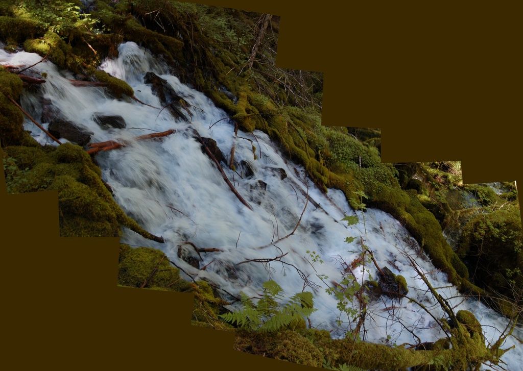
This spring, on it's own, has a flow that's twice (!) the flow through the Eugene Municipal water system. I don't recall the actual flow rate, but it's on the order of a few cubic meters per second. Now Eugene, the second largest city in Oregon, has an estimated population that's nearly 160,000 people. So this spring by itself releases enough water to supply the needs of a city of about a third of a million.

When lava blocked Clear Lake, about 3000 years ago, the rising water covered numerous springs that emerge in the area. They're still there, just hidden underwater. But I'm told there is an especially voluminous one near the northeast edge of the shore. I'd like to imagine that before it was drowned, this is roughly what it looked like. But maybe even bigger!

Photos stitched in HugIn, empty areas filled in Paint.Net. July 7, 2013. No location.

Friday, April 10, 2015

Geo 1095: April 10, Day 830: Float Your Boat

A final shot, for now, of Clear Lake, this one was taken on the McKenzie hydrology trip with Anne, Chris, and Dana. It was on this trip that Anne showed us some of the wonders that water can pull off in this drainage. In terms of visible water, Clear Lake is where it all begins, but the real story starts across the many, many square miles of recent rubbly lava flows uphill from here. Rain and snowmelt sluices into the fractures, and over a period of years, trickles underground to emerge at this location. I'm particularly fond of this photo, because the boat and the reflection of its passengers are visually confusing. It looks as if the boat is actually floating a foot or so above the water's surface. Of course it isn't, but it's this sort of optical delusion that makes me eschew the dock.

Also, non sequitur sidenote, today is the 200th anniversary of the largest volcanic eruption in human-recorded history: Tambora blew up on today's date in 1815. Here's a post describing it and contemporary observations, from Dr. Skyskull. Here's another discussing Tambora specifically, and large volcanic eruptions generally, in terms of their climatic effects. Lots of new-to-me information in both of those recommended readings. Followup, 4:08 PM: Here's another great read on Tambora from Erik Klemetti, with lots of links for additional reading, on the sheer, mind boggling scale of this eruption. One spoiler: the eruption released energy roughly equivalent to 2.2 million times the amount released in the Hiroshima blast.

Photo unmodified. July 7, 2013. FlashEarth Location.

Thursday, April 9, 2015

Geo 1095: April 9, Day 829: "I'm On A Dock!"

Dana and B. taking in the sights at Clear Lake. Dana and I have now been here several times, but this was B's first visit. As I mentioned a few days ago, with its lack of things to hang onto, and the dizzying effect of the deep and nearly transparent water, I'm just not comfortable on the dock. So I land lubbed this visit out and stuck to shore.

Photo unmodified. October 9, 2014. FlashEarth Location.

Wednesday, April 8, 2015

Geo 1095: April 8, Day 828: Belknap and Echoes of the Past

Looking roughly southeast from near the concession building, we can see the irregular toe of the lava flows on the opposite side of Clear Lake, and I'm pretty sure that's Belknap Crater, up near McKenzie Pass, on the right horizon. Once again, I love the way the golds and reds of the fall foliage echo the fiery events of three millennia ago.

Photo unmodified. October 9, 2014. FlashEarth Location.

Tuesday, April 7, 2015

Geo 1095: April 7, Day 827: Ghost Forest

That underwater stump lived and died about 3000 years ago. Think about that. It's one ghost from a forest of many others that were drowned when a lava flow blocked this drainage, to create Clear Lake three millennia in the past. For reference, Rome was founded about 250 years later. The big springs in this basin must have been spectacular to the Native Americans living in the area, as surely they did, though they may have migrated to lower elevations for the winter. Gazing upon, and through, these crystalline waters seems to trigger an introspective chord in me. Think of what was lost in this event. Look at what was gained.

This is why I love geology.

Photo unmodified. October 9, 2014. FlashEarth Location.

Monday, April 6, 2015

Geo 1095: April 6, Day 826: Clear Lake

Moving along from the meadow bed of Fish Lake, we come to the headwaters of the McKenzie River. Clear Lake is by no means the only location of large springs in this drainage, but it's almost certainly the most voluminous. The clarity of the water is stunning- so high, in fact, that I'm very uncomfortable on the dock unless I have something sturdy to hold on to. I rely heavily of vision and touch to keep my balance, and the water is so clear, it's almost like it's not there. For this photo, I was actually standing on the gangplank down to the dock. Holding onto the railing.

Photos stitched in HugIn, otherwise unmodified. October 9, 2014. FlashEarth Location.

Sunday, April 5, 2015

Geo 1095: April 5, Day 825: Parking Lot Puzzle

The parking lot at Fish Lake is bordered with blocks of basalt to keep vehicles in the intended area. This one, as I recall, was to the right (south) if you're facing the restroom, maybe two or three "blocks" away from that path. Here's the puzzle: there are a number of similar features in this photo which fairly consistently indicate what the direction of "up" was when this block of lava cooled. What are those features, how did they form, and what direction was "up" at the time? Answers in comments, and I'll post my own if a good one isn't offered before I get ready to go home tomorrow.

Followup, April 6, 4:06 PM:
In the above annotation, I've outlined six "lava drips," or as Hollie, in her correct guess in the comments described them, "lavacicles." The outlines are solid lines, and I've roughly bisected them with dotted arrows, which point in the direction that was down when the drops solidified. There's some variation, but all the drops point up and to the left, so "up" was down and to the right. As Hollie noted, this was likely the roof of a lava tube, or at least a large bubble in this flow.

Photo unmodified. October 9, 2014. FlashEarth Location.

Sunday Funnies: Easter Edition

Jesus died, and was resurrected, to save the souls of ravioli.
imgur
Tastefully Offensive
Sarah Andersen
Medium Large
Tastefully Offensive
 "How chocolate bunnies are born." Sober in a Nightclub
Savage Chickens
The Far Left Side
Signe Wilson
What Would Jack Do?
"A very dedicated scientist." Tastefully Offensive
"Acting!" Tastefully Offensive
PhD Comics
"Almost." Tastefully Offensive
Jim Benton
Sober in a Nightclub
"Well. That escalated quickly." What Would Jack Do?
Funny to Me
Tastefully Offensive
Wondermark
Sober in a Nightclub
Rosemary Mosco
Very Demotivational
SMBC
Sober in a Nightclub
ChannelAte
Very Demotivational
Tastefully Offensive
Or not. Tastefully Offensive
SMBC
Jim Benton
Tastefully Offensive
The Onion- and folks in my neighborhood will get a kick out of the dateline of the article.
Derpy Cats
Cheezburger
Tastefully Offensive
Blackadder
Tastefully Offensive
Ugliest Tattoos
Tom Toles
"Suiting Up for the Moon," from Astronomy Picture of the Day (April 1, of course.)
Pie Comic
Savage Chickens
GraphJam
Jim Benton
Bad Newspaper
Tastefully Offensive
"Making a spelling mistake in front of the class" What Should We Call Grad School?
Sober in a Nightclub
The Odd 1s Out