Of course, getting there is half the
 The quickest route from the Willamette Valley to the general area is to take 58 from Eugene to US 97 south of Gilchrist/Crescent. Going south on 97, a traveler would pass close by Crater Lake, making that park an easy side trip. Very nice pumice samples can be collected outside the park north of Chemult. From near Chiloquin, one can bypass Klamath Falls with the Sprague River cutoff to Rt 140, then drive east to Lakeview.
Another route to or from passes through Fort Rock Valley and close by Christmas Lake Valley along Route 31. From north to south along this route, geologic features of note include:
- Hole-in-the-Ground: A maar, about a mile in diameter

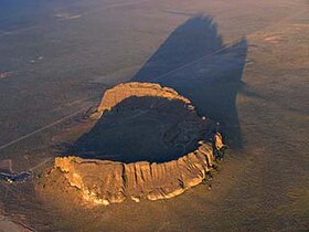
- Fort Rock, a tuff ring

- Table Rock, A somewhat eroded, but generally beautifully preserved, tuff cone. (Picture from here; description and travel log at the link.)

- A side trip into the Christmas Lake Valley area would allow a visit to Crack-in-the-Ground,
 the Christmas Valley Sand Dunes,
  and a major source of diatomite. Diatomite is mined on a road named Kitty Litter Lane... guess what it's used for?
 - Picture Rock Pass- home of a boulder with detailed petroglyphs
- Abert Rim is frequently described as the one of the tallest fault scarps in the US- I'm dubious, nevertheless, it is seriously impressive.


