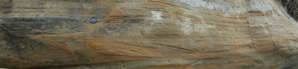
Saturday, November 1, 2014

Geo 730: November 1, Day 670: The Elephant's Footprint

Looking roughly south-southwest along the base of Elephant Rock, we can see how the resistant Columbia River Basalt stands out, while the less resistant Astoria Formation is eroding back and undercutting it. Given the jointing pattern, it's predictable that sometime in the not-too-distant future, a substantial rockfall will bring down many tons of basalt, forming a pile of talus which, for a short time, will armor the sediments from further erosion. Then the cobbles and boulders will break up and be carried away by wave action, and the whole process will start over.

Another nice thing about this photo is that you can see, especially in the left-most extent of the base of the rock, that the joints are nearly perpendicular to the contact between the basalt and the sediment, which is what one would expect if it was an igneous ball-and-pillow structure instead of a dike.

Photo unmodified. July 15, 2014. FlashEarth Location.

Friday, October 31, 2014

Geo 730: October 31, Day 669: Faulty Loading?

The faults from yesterday's panorama are visible in the lower right, but here we can also see the overlying Columbia River Basalt, which I'm nearly convinced now invaded in an igneous form of ball-and-pillow structure. That form of deformation is normally the purview of soft sediments but in the case of Elephant Rock, the denser, sinking, mass was basaltic lava. The vertical columnar joints strongly imply that the feature is not a dike, as it appears to be, and it took a couple days of puzzled frustration for me to come up with a plausible alternative.

Yesterday, I was looking over the nature of the offset on these small faults, supposing they were associated with subsequent tectonism following the lithification of these two units. Looking at this photo, I have another guess to toss out: they look as if they may be fairly similar in strike to the outcrop's face. If that's the case, the fault just to the left of the lens cap is farther under the basalt cylinder than the one roughly a foot to the right. This in turn suggests that the faults might be loading structures. The inner sediments, more heavily loaded, sheared downwards with respect to the less-heavily loaded sediments outward. Keep in mind, that's just a guess, but it would imply the faults were contemporaneous with the basalt emplacement.

Photo unmodified. July 15, 2014. FlashEarth Location.

Have A Screaming Good Halloween!


Yes, I will always include All Souls Night in my Halloween posts. Because reasons.
Buttersafe
Funny to Me
Darius Whiteplume
The Far Left Side
Little Harley Things
Darius Whiteplume
Partially Clips
Sober in a Nightclub
Blueberry Touches
A Zillion Dollar Comics
Surviving the World
 "A tailless whip scorpion with pink babies covering her back." @RealScientists
Aaron Davis, Facebook
Medium Large

Shriekback, Nemesis
Tastefully Offensive
Liz Climo
Heavy Grinder, Facebook
Expert Heavy Equipment, Facebook
Tastefully Offensive
Medium Large
Two of six "Unwanted Halloween Candies," From Medium Large
Ranker: "31 Terrifying GIFs That Will Keep You Up All Night" This is #3, and IMO, the best one.
Jim Benton
I Hate My Parents
"Cårven der Pümpkin" Blackadder
#3 from "Skulls and Bones," at In Focus (21 Photos).
Buttersafe
Tastefully Offensive
Matt Roller

"Wednesday and Lurch Dancing to Megadeth"
Sober in a Nightclub

The Classic Halloween Song. It's probably lip-synched, but still, fun! I'd never seen a "live" version before. And below is a very funny updated version featuring more recent movie "monsters."

Modern Monster Mash - Key of Awesome #91
 This couldn't be more appropriately scary for today. Via @marksluckie
Toles, Via @soxfaneast
Maximumble
"This goat has seen The Exorcist too many times." Senor Gif
Shoebox Blog
Sober in a Nightclub

I always feel as if I haven't found enough really creepy bits, so if I come across any more this weekend, I'll update this post.

Thursday, October 30, 2014

Geo 730: October 30, Day 668: Panoramic Cross Beds

There's quite a lot going on in this photo of the base of Elephant rock at Seal Rock State Park. Directly below the lens cap (52 mm diameter) is a bundle of simple laminar beds, then below that is the featured feature, so to speak, a beautiful set off cross-bedded layers. In that set, below and a bit to the left of the lens cap is an example of soft sediment deformation; I'd call that a ball-and-pillow structure. In that same horizon, but about halfway between directly below the lens cap and the right edge, there's another likely example of ball-and-pillow deformation. These are a little amusing, because in a small way, they mimic the overall structure of the invasive Columbia River Basalt forming the resistant cap of this rock. Finally, on the right side, several minor faults cut through the sequence. The interaction of the left-most of them with the cross-bedding is interesting. I'm trying to get back into the habit of hosting these large panoramas elsewhere, so their size isn't so reduced by Blogger; you can right-click the photo and open it in a new tab for full size gloriosity.

Panorama stitched in HugIn. July 15, 2014. FlashEarth Location.

Wednesday, October 29, 2014

Geo 730: October 29, Day 667: Cross Bedded Astoria Formation

I'm told that the rock here, sediments under Columbia River Basalt of Elephant Rock at Seal Rock State Park, are also Astoria Formation. The tide was out far enough at this point that we could get down to beach level to get a good look at them. I was immediately struck by the terrific cross bedding visible below and to the right of the lens cap. In fact, I need to assemble a series of photos of these beds into a panorama for tomorrow.

Photo unmodified. July 15, 2014. FlashEarth Location.

Geo 730: October 28, Day 666: Seal Rock Sea Shore

Looking along the northward extent of the invasive dike(s) at Seal Rock State Park. There's a tombolo developing on the shoreward side of the large stack to the left. The stack blocks much of the incoming wave energy from the open ocean, which means the area behind it becomes a sediment trap. In this case the sediment is course cobbles and boulders; in other it might be sand. The odd light on the salal (which I mentioned a few days ago) in the foreground is the result of my camera flash, which often goes off unwanted and unneeded when I have it in automatic mode. In this case, I like the effect, though.

Photo unmodified. July 15, 2014. FlashEarth Location.

Geo 730: October 27, Day 665: Muddy Waters

We were quite taken by the visible wave-caused sediment transport from this vantage point. It's particularly obvious as the backwash pushes into the advancing wave. Out of frame to the left is a nice little sea cave Dana and I visited on our first visit to this park, at a much lower tide (direct link to relevant photo).

Photo unmodified. July 15, 2014. FlashEarth Location.

Geo 730: October 26, Day 664: Beverly Beach

Even though the Willamette Valley, about 50 miles inland, is generally in the 80's to low 90's in mid-July, the coast is often foggy, or as here, hazy. And cool. With the wind, it's not unfair to describe it as cold. We're looking to the south, toward Beverly Beach. The graceful bridge near the middle of the shoreline is the pedestrian walkway under Route 101 from the day use/camping areas out to the beach access area. The southern stretch, beginning maybe 150 yards south from the bridge, is chock full of fossil shells (see ~middle part of that post for some examples) as well awesome erosional and weathering patterns.

Photo unmodified. July 15, 2014. FlashEarth Location.