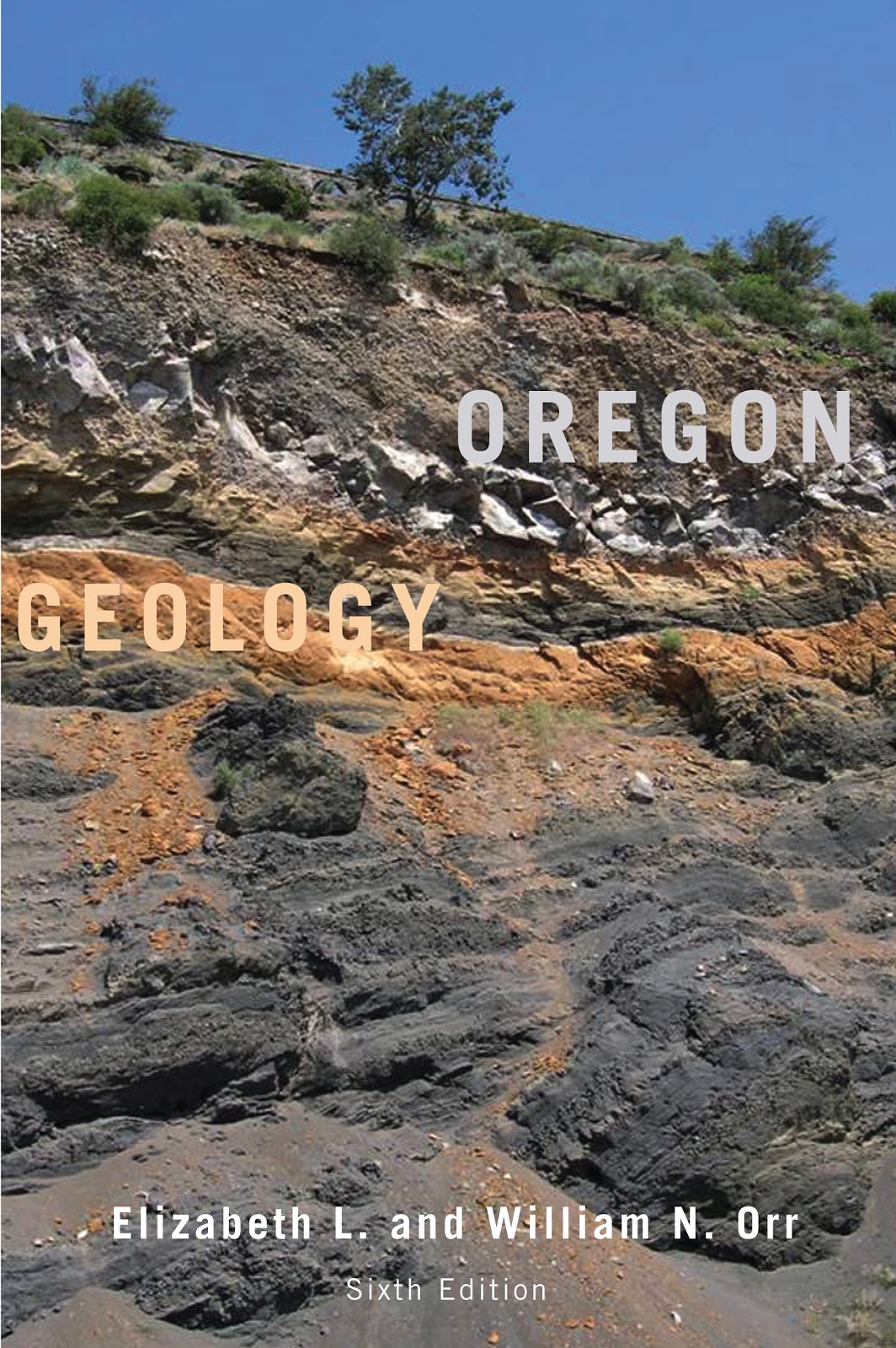
Saturday, August 31, 2013

Geo 365: August 31, Day 243: Cooler

After Dana figured out the origin of The Wall, we walked out the trace to see if we could spot where it crossed the river. You can see the blocks in and across the stream. You can also see where the nearby residents have set up an idyllic spot to cool off. That looks splendid!

Photo unmodified. May 6, 2013. Location uncertain, but maybe here.

Friday, August 30, 2013

Book Review: Oregon Geology, Sixth Edition

(Image from here) This is an entry for Accretionary Wedge #59, on the topic of geology field guides.

As noted at the bottom of the cover, this is the sixth edition of a book first written in the early 1960's by Ewart Baldwin. I have, at one time or another, owned each of those editions, and as a rule, I find them indispensable. Baldwin was a stratigrapher, and the early editions reflected that- heavy on unit names and discussion of plausible environments. Prior to the acceptance of plate tectonic theory, though, and the concept of terrane accretion in particular, this must have been a terribly frustrating region to try to work out broad geological relationships. It still frequently is, but the concepts developed from 1980 to the end of that decade marked an enormous leap forward.

A great deal of the work in this understanding was done during that decade, and I looked forward eagerly to the arrival of the GSA Bulletin and Geology each month, and regularly stopped by the OSU library to skim through tables of contents looking for pertinent articles. Starting with the fourth edition, in 1992, the Orrs collaborated with Baldwin, and began seriously integrating the plate tectonic revelations of the previous fifteen years. In the fifth edition, 1999, Baldwin was no longer listed as an author, but the Orrs followed the same organizational format, and greatly expanded on the role of plate tectonics in Oregon's geologic evolution.

Since I quit following the professional literature at the time I started my master's work in education in 1991 - lack of time, not lack of interest- I presumed work was continuing, but had no idea what was being accomplished. Very little of that was reflected in the 1999 edition- that is, most of the updates there were already somewhat familiar to me.

With the sixth edition, though, there is a great deal of new material that I've not seen before, and it's exhilarating to go through it. A new feature is some short biographical sketches on geologists whose work has been foundational to our current understandings in each chapter- a nice touch. And it looks as if there are an additional 50 pages or so.

Some caveats: this is not a book I personally would recommend that one should try to sit down with and read. It is an extremely useful reference, but I tend to consume it a few pages at a time to satisfy a particular question. It is fairly dense- it is not "fun" to read. The authors make no pretense they're out to entertain you- though if geology is a passion (raises hand), it is quite engaging. Sadly, I cannot recommend this for raw beginners. On the other hand, if you're not put off by terminology (the book does not have a glossary, so you need to either know the words or use an external reference), have a decent grasp of internal and surface earth processes, and some experience at "thinking like a geologist," whatever that means, this would be an excellent resource for those living in the PNW, or even visitors looking to understand the foundations of this magnificent state. In other words, I would describe this as must-have for anyone with the first year geology sequence, or equivalent, under their belt who expects to spend time in Oregon. While it is not a "field guide" in the sense that it doesn't give you nice mile markers to a series of stops along a route, it is a text I carry with me on trips that get into areas with which I'm not as familiar. It's an incredibly helpful on-the-fly reference.

The organization is quite straight-forward: Oregon is broken into a number of physiographic provinces based on landforms and bedrock geology. The text addresses each of these from oldest to youngest. While there is obviously some overlap in age, each of these provinces has, for the most part, it's own unique geologic history, and the organizational structure works very well.

The book is heavily illustrated with maps, sketches, charts, diagrams, cross-sections, et cetera. Which brings me to a minor quibble, and I think, the reason for the name change from "Geology of Oregon" to "Oregon Geology" The previous editions were published by Kendall-Hunt (incidentally, a publisher by whom I've been almost entirely pleased with respect to their geo publications), and I'd not realized how much their printing quality affected my appreciation for the work. The new edition was published by OSU Printing, and while the image quality isn't bad, neither is it terribly good. Maps seem a little muddy. Identifiers need some squinting to make out. On the other hand, the fifth edition cost in excess of $60; this one is offered at Amazon for roughly a quarter of that, $16.37. So I suppose some loss of image quality is worth the ~$50 savings.(Good Lord! Just checked: Kendal Hunt still offers the 5th edition... at $128! NOPE!) My suspicion is that copyrights held by KH necessitated the name change.

So, to summarize, this is an extremely useful book that will eventually become dog-eared from frequent referencing and harsh treatment in the field. Get a little geology under your belt before trying to use it, but if you spend any time in the state as a geology enthusiast, this book is a necessity.

And to close, I've found many errors in Roadside Geology of Oregon, and have been told of many others. It was not a terribly useful book when it was first published in 1978, and with no new editions since then, it's pathetically out of date. I've been unimpressed with that series generally, but the Oregon edition in particular is just heinous.

Geo 365: August 30, Day 242: Just Another Dike in The Wall

So here's the answer: "The Wall" is the product of a substantial dike, almost certainly of Oligocene age, intruding and baking surrounding sediments. The central Coast Range had a number of these intrusives during that time, likely associated with re-establishing the subduction zone following the accretion of Siletzia, the Coast Range block. Texturally and compositionally, this is a basalt, though it is intrusive, not extrusive. Basalt is much more useful as a road metal than the much more abundant and quickly weathering Tyee sandstones, so this restricted outcrop of basaltic rock had some value as a gravel quarry. Operations focused on the dike itself, and took a small amount of the surrounding contact metamorphosed Tyee sandstone, which, as a hornfels, is also tougher than the unaltered parent material.

"The Wall" is simply the remnant of that quarry: tougher, linear, tall, and quite sheer, after the dike was removed for gravel. The previous three days' photos have all shown contacts between the now absent dike and surrounding Tyee Formation, and yesterday's photo shows a couple of subsidiary dikelets squeezed into joints around the main intrusive (The areas highlighted between the pair of lines and under the ellipse.)

An acquaintance of my friend Bob contracted to put in a road a bit upstream of this spot, and when he was told, Bob asked if he found the dike. The contractor responded, "You knew about that!? I wish we had!" They had to subcontract out for drilling and blasting this obstacle and ended up losing money on the deal. Geology, no matter how simple, mundane and trivial, has the darnedest way of making itself important.

Photo by Dana Hunter, unmodified. May 6, 2013. Location uncertain, but maybe here.

Thursday, August 29, 2013

Geo 365: August 29, Day 241: One More Set of Clues

Okay, I lied... no answer today. I forgot I did have one useful photo of my own that may help clarify the origin of the wall. Below is an annotation to draw your attention to the important bits.
That darker rock above the hammer head should be a dead giveaway. The small bit under the oval to the right is similar. And the arrows emphasize the color gradient I was hoping someone might notice in the last two days' pictures. Another thing that may help: this is Tyee Formation, which usually weathers quickly. While this outcrop is at least 25 or 30 years old, corners and edges are still sharp and fresh. Cuts of similar age elsewhere in this unit would be quite punky. Answer tomorrow, I promise. There aren't any more clue photos; the only one left has the answer.

Photo unmodified. May 6, 2013. Location uncertain, but maybe here.

Wednesday, August 28, 2013

Geo 365: August 28, Day 240: Clue, Close-Up

Still at the wall, this is another framing, and closer perspective, of yesterday's clue to the question, "How was 'The Wall' formed? Answer tomorrow...

Photo by Dana Hunter, unmodified. May 6, 2013. Location uncertain, but maybe here.

Tuesday, August 27, 2013

Geo 365: August 27, Day 239: Under the Shrubbery

The difficulty with this spot is several-fold: first, with all the young trees coming up back in the notch, it looks more like an area to avoid than an area to explore. Second, all that brush obscures much of what you might want to be looking at- it's not obvious from out by the road and pull-out that there even is anything to see under all the foliage. Third, the moist, shady conditions under all that cover means that moss, lichen, and algae have rendered all the colors a sort of muddy, muted greenish- distinctions have been largely suppressed. Finally, because it's all so, well, dull, I didn't get very many pictures except of the wall itself. Dana got a few more, though, and this is one of hers. I'll forgo a description here, and leave it to the reader to see if they can spot a tell-tale clue to the wall's genesis.

Photo by Dana Hunter, unmodified. May 6, 2013. Location uncertain, but maybe here. (That seems closer to Harlan than I remember, but it's the only spot that even looks like a possible match)

Monday, August 26, 2013

Geo 365: August 26, Day 238: Harlan Road Rampart

Another panorama of "The Wall," with a car for scale. This is a popular local climbing spot, and you can see chalk marks on favored hand-holds. (You can see options for viewing sizes by right-clicking on the image here.) The clues you need to figure out what's going on at this spot are back under the alders and maples to the right...

Panorama stitched in HugIn. May 6, 2013. Location uncertain.

Sunday, August 25, 2013

Sunday Funnies: Fistbump Edition

Funny to Me
Blackadder
Sober in a Nightclub
Bizarro
"When I prep a space for RNA work" What Should We Call Grad School?
ChannelAte
Bits and Pieces
Tastefully Offensive
Wondermark
Steak Smoothie
Poorly Drawn Lines
"If it fits, I... Okay, nevermind." Cheezburger
Bits and Pieces
"Nerd vandalism" Bits and Pieces
Matt Davies
Savage Chickens
"When you receive an email asking if anyone wants the leftover rock samples from the retiring professor's office" Geology is Hard
Bizarro
 
Tastefully Offensive
ChannelAte
Julia Segal
What Would Jack Do?
Bits and Pieces
Up and Out
Married to the Sea
"If the internet goes down" Senor Gif
Very Demotivational
Partially Clips (Some fun thoughts on the creative process at the link)
"No one understands thermo until they teach it. And then you can throw in a few words like 'fugacity' and even then the instructors are just pretending along with everyone else." Surviving the World
Tastefully Offensive
"We’re gonna bomb the crap out of childhood obesity" Wil Wheaton's Tumblr
"Finding my tent without a headlamp" Geology is Hard
 Tastefully Offensive
What Would Jack Do?
Poorly Drawn Lines
"Wow, the new Monsters Inc movie looks brutal." Wil Wheaton's Tumblr
"When everyone from field camp realizes we have to go back to school and sit inside a classroom next week" Geology is Hard
SMBC