Saturday, January 11, 2014

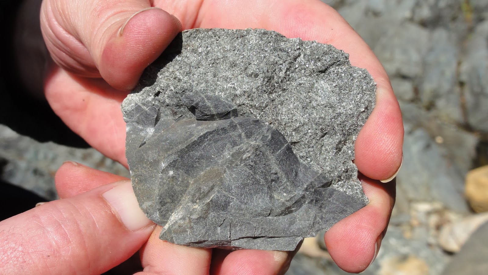
Geo 730: Jan. 11, Day 376: A Chip Off the Old Block

Another shot from Dana, this shows a small hand sample across the rim of a dike and the surrounding diabase. I can't tell with any certainty whether this is older dike material, or unusually fine magma chamber gabbro, though I'd lean toward the former. As we saw in Thursday's photo, there is a lot of variation in grain size, even within a single dike, and in yesterday's photo, the cumulate gabbro tends to be pretty coarse-grained (if that's what we were actually seeing in that photo).

Photo by Dana Hunter, unmodified. May 8, 2013. FlashEarth Location actually kinda looks like it might be right. Indexed

Friday, January 10, 2014

Geo 730: Jan. 10, Day 375: A Different Perspective

Another shot from Dana, this was taken at the same time as yesterday's photo. We're looking at the same scene from a different angle- I would be standing just off to the left of this frame. The chilled margins should be apparent, and to the lower right is the edge of yet another dike. There may be some igneous layering in the coarser, more gabbroic, rock between those two dikes, but it's hard to be certain. Remember, the dikes would have originally been nearly vertical, and igneous layering would be essentially horizontal, so the orientations relative to each other look right.

Photo by Dana Hunter, unmodified. May 8, 2013. FlashEarth Location actually kinda looks like it might be right. Indexed

Thursday, January 9, 2014

Geo 365: The Map, Updated

https://www.google.com/fusiontables/embedviz?q=select+col4+from+155PdOQQ2FHnCavwsS7B-6y8Gu_l7ygpIyps7evs&viz=MAP&h=false&lat=43.75691842912924&lng=-121.75220632601922&t=3&z=8&l=col4&y=2&tmplt=2&hml=TWO_COL_LAT_LNG
An unexpected addition today: Ron Schott has updated the Geo 365 Map so that in addition to Lat/Lon information and a link to the original post, clicking on a "pin" also brings up a copy of the photo. This is a lot of fun to explore!

Geo 730: Jan. 9, Day 374: Chilled Margins

I posted this photo last May as a "teaser," but I think it's worth revisiting in context. The chilled margins of the dike under the hammer are quite apparent in this photo, and give visiting geologists the ability to relatively date these dikes- that is, determine which are younger and which are older, relative to each other. In the case above, this dike is younger than the material on either side, as shown in the annotation below.

I created the following schematic in much the same way that sheeted dike complexes actually form: starting with a single dike (1), then pulling it apart to inject (2). As it turns out, the two dikes labeled (2) don't butt up against each other, so you'd have to guess which one came first- there's no way to say for certain. Then the dike (2) on the left was split and intruded by (3). I'm not sure this has any practical scientific value, but as an intellectual curiosity, pondering the immensity and time scales of earth processes, and getting a gut feeling for spreading ridge dynamics, I find this sort of puzzle terribly rewarding.
Photo unmodified. May 8, 2013. FlashEarth Location entirely conjectural. Indexed

Wednesday, January 8, 2014

Geo 730: Jan. 8, Day 373: Josephine Between the Sheets

Once again, there are a few darker dikes, one a yard or so left of Dana's knee, and a couple more over by the river, but ALL the rock in this photo consists of basaltic dikes in roughly parallel sheets. I'm still a little baffled as to our location. This was mid- to late-morning (Followup: 10:00 AM, according to metadata in Dana's photos), so Dana's shadow is falling NW to NNW, which is more or less the same direction the river is flowing. The river itself is tightly constrained between two sharp banks- it's not a gravelly shore. And the road turns sharply to the left beyond Dana's neck and head, with an embankment that's basically devoid of vegetation. I simply can't find a good match for this spot in FlashEarth in the reach between the N/S Fork confluence and the bridge that carries the road to the south side of the river. Below is another possibility, but the shore doesn't look right, and I think we were were further downstream- that is, more of a drive- from the bridge than this seems to be.

Photo unmodified. May 8, 2013. FlashEarth Location entirely conjectural. Indexed

Tuesday, January 7, 2014

Geo 730: Jan. 7, Day 372: From the Middle of Oceanic Crust

A photo by Dana, this is the same spot as yesterday's photo, with the hammer in the same position. I'm more confident about my tentative gabbro identification after looking through some of her shots. Again, the prominant ~2 cm basalt dike really stands out. If you look about 10 cm up from that, you can see another that's much lighter, but still a bit darker than its host rock. Those two, in turn, appear to be in a light-colored, fine-grained parcel, which is bounded below by material that's similar in color and tone, but coarser-grained. The variations are subtle, but I'm convinced they're real. The problem is that all of the dike material is of similar, basaltic, composition, and it's all been moderately metamorphosed. I don't see the green here; it's too subtle for me. But there are plenty of non-color cues that tell me there's a metamorphic overprint. Often, there are clearly evident variations in texture and tone that convey chilled rims- which we'll get at in the next few days- but to a large extent, it's much easier to distinguish the dike boundaries in person, as opposed to in photographs.
Photo by Dana Hunter, unmodified. May 8, 2013. FlashEarth Location largely hypothetical. Indexed

Monday, January 6, 2014

Geo 730: Jan. 6, Day 371: Sheeted Dikes

Unfortunately, we only made one stop with really good exposures of sheeted dikes, but it was a good exposure. Originally, these planar intrusions of basalt would have been more or less vertical in orientation, but they were rolled over onto their side during the accretion of this terrane. Indeed, it's that roll-over that makes for the nice, continuous sequences in the Josephine: if they were still close to vertical, one would observe little variation in the discrete blocks between faults. As it stands, geologists can walk steadily up- or down-section, not continuously, but in segments that allow reconstruction of an entire sequence from the upper mantle to a thick pile of sea floor sediments.

I can't say for certain at this point, but it looks as if the coarser, salt-and-pepper looking material under the hammer's head is a remnant of the gabboic magma chamber, but the majority of the rock in this photo is comprised of dikes intruded into dikes intruded into dikes. This was once described to me as "all dikes, no host rock," which was terribly confusing. I think a better way to describe it is, "such a profusion of dikes, they are their own host rock." The diagram below gives a good idea of the general setting of where and how such rocks are formed, atop a spreading ridge. As the two plates spread apart, dikes repeatedly intrude as sheets between the melt lens and and the axial summit graben.
Image credit: Ocean Drilling Program Scientific Prospectus No. 106 (July 2002). Image source.

Now why belabor this? The fact is, some three-quarters of the earth's crust was and is being formed in settings just like this. But being able to walk on and look at these rocks directly is an extraordinarily rare opportunity, despite their overwhelming abundance. First, the majority of them are deep under water. Second, the majority of them are covered with at least thin, and in most cases thick, beds of sediment. Finally, these are, as a rule, under yet another thick pile of volcanic basalt- according to the above diagram, 200-800 meters worth. Furthermore, due to their relatively high density, they tend to be recycled into the mantle during subduction. It's an unusual situation in which a chunk like this gets smacked up onto continental crust and uplifted to be eroded and put within human reach.

So, as bland and unremarkable as this outcrop might look to non-geologists, understanding what we're really seeing is a breath-taking experience. And the scenery's not shoddy, either.

Photo unmodified. May 8, 2013. FlashEarth Location is, shall we say, "mostly speculative."

Addendum: By request, I've annotated a few of the dikes and other features that stand out to me. The problem with this particular view is that much of the surface on the closer side of the river is more or less parallel to the strike and dip of the dikes themselves. You can get a sense of their orientation by looking at the rough lamination of the dikes on the other side of the river. The two bits I've labeled as "klippes" are likely  high-standing remnants of the same dike, which may or may not be the same as the one I've highlighted under the handle of the hammer. Still confused? Don't worry, I have a few more photos of this spot coming up, some of which are much clearer.