Showing posts with label Geo 730. Show all posts

Wednesday, January 7, 2015

Geo 365/730/1095: Mapping ALL The Geo!

Yesterday, Ron Schott sent me the link and the embed code for his ongoing project to map all the locations in my own ongoing "Geo" series. Theoretically, you should be able to drag and zoom the above map to explore all of the (currently) 736 photos and descriptions in the project. In practice, especially in the Geo 365 set, I frequently reused the exact same lat/lon FlashEarth location for photos in close proximity to one another, which means several "dots" are imposed on a single point, and are not individually resolvable. This past year, I made an effort to shift the location each day, at least slightly, but I suspect that unless you are zoomed in to a high degree, they may still be difficult to resolve individually. If you'd prefer to open this as a full window, which I recommend, the map can be accessed here.

As a reminder, this series was and is not intended to be devoted specifically to Oregon geology- though goodness knows, I've barely scratched the surface here. The focus on Oregon simply reflects the fact that I've spent very little time out of the state since I acquired a digital camera. In Dana's and my geogalvanting over the last four years and a few months, we've just skimmed into northwestern-most California one day, and northwest-most Nevada on another. But we're making planz... heh, heh, heh!

Wednesday, December 31, 2014

Geo 730: December 31, Day 730: Spring Mosaic

This seems like a highly appropriate, cheerful, and punny photo with which to end the year: a mosaic of wildlife around a Cascade spring to create a setting for a water fountain, in the lower entryway of Timberline Lodge. It doesn't hurt that everything here is made of geological materials. There's the raw andesite/dacite blocks in the walls, fired clay in the tiles of the floor and mosaic, glass in the enamel of the mosaic tiles, with various metallic salts for pigment, and copper and zinc alloyed to make the brass of the drinking fountain fixture itself. (It's possible this is bronze; I've never really been confident in telling the two apart. If that is the case, it's an alloy of copper and tin.)  And, of course, once tonight's festivities have concluded, what's the next major annual event we're all looking forward to? Why, spring, of course!

Update, 1:30 PM, 12/31/14: The animals, clockwise from upper left, are deer, bear, wild turkey, dragonfly, salmon, and skunk. The plants, in same order, are maybe huckleberry, but not sure, rhododendron, Douglas fir (probably), trillium, and skunk cabbage.

Happy New Year, all! See you on the flip side.

Photo unmodified. October 10, 2012. FlashEarth Location (approximate).

Tuesday, December 30, 2014

Geo 730: December 30, Day 729: Seen Lurking in Timberline Lodge

This reclining cougar panel can be found over one of the doors in Timberline Lodge. There's a similar panel of coyotes that I photographed a couple times, but they're too blurry to include in the Geo series. I love the craftwork up here; it's rough-hewn, but so evocative of this landscape. Speaking of which, how is this geology? Only two or three centuries ago, wild lands such as this were a source of fear, or at least unease, avoided by anyone who could, aside from the most intrepid explorers. It's only been in the last couple centuries that western civilization has come to romanticize and seek out alpine areas, deep forests, or "barren" deserts. When this lodge was started in the 1930s, that shift was well underway, and people were excited to get away from the hubbub of city living, and up into the clear mountain air. Later, in the 1950s and 60s, when alpine skiing became popular in the US, this lodge became one of the first skiing meccas in Oregon.

In short, if it wasn't for the geology here, this lodge would never have existed.

Photo unmodified. October 10, 2012. FlashEarth Location (approximate).

Monday, December 29, 2014

Geo 730: December 29, Day 728: Another Chimney

This is the chimney over the great hearth in the main guest lounge of Timberline lodge, the upper continuation from this photo. Most of the materials used in the construction of the lodge were, at the very least, shaped on site, and many, including most of the timber and stone were harvested nearby. In particular, I'm admiring the wrought iron wind vane above the chimney opening. You can see that, on this afternoon, the wind was coming from the southeast.

Keep in mind the purpose of the CCC and WPA projects was not to create wonderful historical artifacts such as Timberline, though it did have that outcome. The purpose was to provide meaningful employment for a generation of people, men, mostly, to help support themselves and their families during the Great Depression, but perhaps more importantly, marketable skills that the workers could use to stay employed in the future when the economy improved.

Photo unmodified. October 10, 2012. FlashEarth Location.

Sunday, December 28, 2014

Geo 730: December 28, Day 727: Timberline Chimney

Oh, wait... I've already used that title. Yes, but this is the outdoor view of the chimney from the dining room. This is the same native andesite/dacite as we saw inside, but there are two reasons it appears darker: first, the light is brigher, so by comparison, the stone is darker. Second, notice how it gets darker toward the top? That's almost certainly soot stains from the smoke. I'm pretty sure the fire is kept burning continuously through the winter. So for this one, at least, I'm not going to have to rationalize why I get to call this photo geologically-related.

Photo unmodified. October 10, 2012. FlashEarth location.

Saturday, December 27, 2014

Geo 730: December 27, Day 726: Dana's Ford

Dana doesn't drive a Ford, I don't think, but I'm not a car person, so I don't pay much attention to them, and really have no idea what kind of car she does drive. It has room for her, me and, often, a traveling companion. That's really all I need to know. But here, she's fording the small creek near Timberline Lodge. If it has a name, I don't know that either.

But for the last bit of outdoor geology before we head into look around the lodge proper (and yes, I'll twist myself into knots explaining how that's geology, too), let's take a look at the clasts in the creek. They tend toward large, but overall, they're poorly sorted. This suggests that the energy of the flow varies widely- which makes sense, given the climate and topography of this location. There's some rounding in the cobbles and boulders large enough to see well at this scale. This makes sense too- the larger clasts impact each other with more energy, rounding corners and edges rapidly, without much traveling distance. But overall, despite some rounding, they're pretty angular. This suggests we can't be too far from the water and sediment sources. The source snowfields of this creek are at most a few thousand feet, a kilometer, or so away. Now the point of this is not pedantry. The point is, if all you could see was the sediment in the creek- no horizon, no vegetation, no location- you could still infer much of the environmental setting, just from the nature and arrangement of the sediment itself. This is what geology is all about, and why it's so enthralling to me. We learn to notice the little clues, and think about them together in such a way as to paint a mental picture of the larger setting, which has often been long lost in the geological record. Here, though, we have the pleasure of the entire landscape available to inspect.

Photo unmodified. October 10, 2012. FlashEarth location.

Friday, December 26, 2014

Geo 730: December 26, Day 725: The Ford

As I mentioned on Christmas Eve, I was a little surprised at how much the stream- damp, but with no flow when we first crossed it- had swollen. It was by no means to the point where we were hesitant to cross, though we were definitely selective about where and how to do so. But there's little doubt that a misstep could have resulted in a wet foot or two. And since this was a day trip, I didn't have a change of socks or other clothes. Fortunately, there were no oopsies.

Photo unmodified. October 10, 2012. FlashEarth location.

Thursday, December 25, 2014

Geo 730: December 25, Day 724: Snow!

This isn't Christmas, but the snowiest event I can ever recall in Corvallis, last February 7th. Is this geology!? Yes, it is! I had intended to post a photo from Mount Bachelor with my family, six years ago, but just learned I don't have that folder on this computer. It's at home on the hard drive. Merry Christmas, all!

Photo unmodified. February 7, 2014. FlashEarth Location.

And to not break off from the tail end of our visit to Timberline, here's an unintentionally humorous warning that became very relevant just a couple weeks after I took the photo.
Photo unmodified. October 10, 2012. FlashEarth location.

Wednesday, December 24, 2014

Geo 730: December 24, Day 723: Brook

I've posted a couple of photos of the leading edge of this "diurnal stream," but I was quite surprised at how much it had swollen by the time it came to cross it again. This shot actually conceals just how much water is flowing, rather than illustrating it. After Christmas, I'll post a couple of others that get across the volume better.

Photo unmodified. October 10, 2012. FlashEarth location.

Tuesday, December 23, 2014

Geo 730: December 23, Day 722: A Final Shot

I have two very similar shots from this spot; the other is zoomed in more closely on the summit amphitheater and Crater Rock, showing more detail there. However, I like the framing of the trees more in this one. This was about as far up the path as we walked before turning around and heading back to the lodge.

Mount Hood is Oregon's tallest peak by quite a bit, at somewhere around 11,239 to 11,249 feet- recent measurements vary- and due to its proximity to, and visibility from, Portland, is probably the leading candidate for Oregon's "iconic" mountain. Crater Lake is likely more recognized, but this would be what most people picture with the phrase "Oregon Cascades." With that said, I'll reiterate that peaks like Hood, and yesterday's shot of Jefferson, are the exceptions rather than the rule for Cascades landscapes.

Photo unmodified. October 10, 2012. FlashEarth location.

Monday, December 22, 2014

Geo 730: December 22, Day 721: Jefferson Again

Looking a bit more directly south than the previous view down the valley on the left, Mount Jefferson sticks up through the smoke and haze from the numerous fires burning on the east side. While Hood is often mentioned as the most likely of Oregon's major Cascade peaks to erupt, Jefferson is among the least likely.

Photo unmodified. October 10, 2012. FlashEarth location.

Geo 730: December 21, Day 720: Looking Downstream

This photo makes it clear how steep the gradient of the Salmon River is on its way down Mount Hood, as well as how loose and rubbly the area being drained by it is. As I mentioned a couple days ago, this view should set alarm bells clanging for the geologically inclined. Anything on low ground near the river in this area is vulnerable to lahars. This high up the mountainside, it's in a significant canyon, so other than occasional trail wipeouts, there's not much to worry about. But this area could serve as a source for a debris flow that runs miles downstream to flatter ground, then fans out, dropping the rubble, and damaging or destroying pretty much everything in its path.

Photo unmodified. October 10, 2012. FlashEarth location.

Saturday, December 20, 2014

Geo 730: December 20, Day 719: Timberline Trail

Timberline Trail circumnavigates all of Mount Hood, as the name implies, near timberline. Here it can be seen descending into the upper valley of the White River (unless you're taking the trail clockwise, in which case it's ascending from that valley). I did consider walking down there, but decided I didn't want to make the climb back up. According to the PDF at the link up front, the trail is "only" 36.6 miles/58.9 kilometers- I could've easily done it in two days, or a leisurely three, 30 years ago, but these days, not so much. This photo also does a good job of showing how persistent the snow is. We were probably right about 6000 feet here (the lodge is at 5960 feet), and that little finger of snow field up the valley appears to be below, or at least close to, our elevation.

Photo unmodified. October 10, 2012. FlashEarth location.

Geo 730: December 19, Day 718: Upper Salmon River

At the end of the dry season, this modest stream is barely a trickle. However, according to Wikipedia (see stats box on upper right), the Timberline area receives an average of 45 feet of snow each winter. (Note this is not the amount of snow on the ground at any time; it's total snowfall.) During spring melt, or during warm rain events, such as we're having today, Dec. 20, 2014, this small stream certainly swells to a torrent. Looking at all the loose rubble in and around the water, and noticing that the banks of the canyon are at a consistent angle of repose, it's easy to see how those high water events can lead to debris flows such as we witnessed earlier in the day at the White River Bridge. All this loose stuff is eager to get downhill.

Photo unmodified. October 10, 2012. FlashEarth location.

Thursday, December 18, 2014

Geo 730: December 18, Day 717: Upper Salmon Valley

The valley directly in front of us here is the upper end of the Salmon River. The pair of valleys beyond that are a tributary to the White River (closer), and the White River (farther). Palmer ice field/glacier appears to the right of the tree in the left middle, and Crater Rock and the Mount Hood summit are above that feature. The winds were from the east this day, so I don't think that cloud could be described as a lenticular.

Photo unmodified. October 10, 2012. FlashEarth location.

Geo 730: December 17, Day 716: Diurnal Stream?

The reason for the question mark in the title is that I'm not sure "diurnal stream" is a valid term, nor the correct one for this situation. Basically, snow melt from ice and snow fields above this spot doesn't melt during the night, so the water flow stops. Then, during the day, if it's warm enough, melting starts again, and the stream gets water. So this stream, at this point at least, flows in stop-and-start daily pulses. I'm not sure I've seen anything like this before, but thinking about it, it doesn't seem it would be all that unusual in alpine settings during the right part of the year. This is one of a series of photos I'd intended to post as animated gifs, but this set is too shaky, with too many out of focus or blurry. The second set has too much in shadow, and doesn't really illustrate the advancing water front very well. And the third, well, long time followers may remember I posted that gif nearly two years ago to mark the end of the first week in the Geo 365 series. That post includes a more complete description of how we happened to discover the nature of this stream, and how we found the daily front of the flow. In this photo, the leading edge is just below and to the left of the small cobble near the middle.

Photo unmodified. October 10, 2012. FlashEarth location.

Tuesday, December 16, 2014

Geo 730: December 16, Day 715: At Timberline

"Timberline" was not a concept I really had when I was growing up. Like "snowline," it wasn't applicable in Ohio. Simply stated, it's the alpine elevation above which climatic conditions are too harsh, too persistently, for trees to grow. In both cases, these lines appear sharp from a distance, but when you're "on" the lines, they're more ragged and not as clear cut. Here, there are clearly some trees that look as if they're doing well, but the one in the left foreground looks as if it might be struggling a bit. As we saw in yesterday's photo, Timberline Lodge is mostly wood, so fire hydrants are a necessity. Also, I suspect this is the approximate location of the fire hydrant line, too.

Photo unmodified. October 10, 2012. FlashEarth Location.

Monday, December 15, 2014

Geo 730: December 15, Day 714: Timberline Chimney

Inside Timberline Lodge, the lighting is dim, and it's not easy (especially as I get older) trying to hold my camera steady for good clarity. Above is the best shot I have of the chimney over the great hearth. This is native stone; I don't know if there was a dedicated quarry for the stonework in the lodge, or if they just used loose blocks laying around on the surface. Goodness knows, there's plenty of those. The lodge was built as a part of the WPA program in the late 30s, and dedicated by FDR in 1937, well before it officially opened to the public. The rustic nature of the lodge is evident here, but on our first pass, Dana and I had been stuck in the car for too long, and wanted to go stretch our legs with a walk. So after a few quick shots, we headed out to the mountainside.

Photo unmodified. October 10, 2012. FlashEarth Location.

Sunday, December 14, 2014

Geo 730: December 14, Day 713: Hood Summit

A closer view of the amphitheater below Mount Hood's summit, and Crater Rock in its center. The striated snowy area directly downhill from Crater Rock is the so-called "Palmer Glacier," though with no bergschrund, I'm not convinced this is actually a glacier rather than an ice field. Palmer is the only site in North America that offers year-round skiing (hence the striations), though I've heard conditions can get pretty awful before the fall snows start falling.

Photo unmodified. October 10, 2012. FlashEarth Location.

Saturday, December 13, 2014

Geo 730: December 13, Day 712: On the Flank of Hood

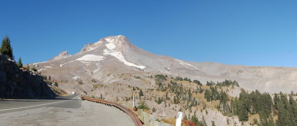
Turning around in the same spot as yesterday's photo of Mount Jefferson, there was Mount Hood, looming over us. I think the White River drainage is the valley near the center that runs off the right side of the photo. The valley running down the left center toward the road is the Salmon River.

Photo unmodified. October 10, 2012. FlashEarth Location.