Sometime around 19,000 years ago, a glacier blocked the Clark Fork River, which flows through Missoula, Montana. An enormous lake filled in behind the glacial dam. Ice is a poor material to build dams with, since it floats. When the lake filled up enough to float the glacial tongue, the water started flowing beneath it, and the dam collapsed. About a month ago, I came across some video clips of a similar (though much smaller scale) modern analogue; I posted one of the clips here. Over a period of a couple of days, roughly 500 cubic miles of water drained from Lake Missoula, and roared out across eastern Washington, then down the Columbia River drainage.

Above: a map of the flooding in eastern and central Washington
The maximum rate of flow at the site of the ice dam has been estimated at 9.5 cubic miles of water per hour. If this rate were sustained, Glacial Lake Missoula would have drained in little more than two days. The maximum rate of flow at Wallula Gap has been estimated at 39.5 cubic miles per day, which would drain the lava field in about two weeks. But these maximum rates of flow probably could not have been maintained for that long. A realistic estimate of the duration of the flood, from the time when water first spilled over the ice dam to the time when scabland streams returned to normal flow, was probably about a month.Here is the Table of Contents for the above-quoted USGS pub. The erosive power and breadth of coverage of these floods is incomprehensible. For example, below is a Google Earth image looking roughly NE through the Columbia River Gorge.
 In the picture above I have labeled Chanticleer Point, Crown Point, and Mt Adams on the skyline. Below is a photo of Crown Point taken from Chanticleer Point.
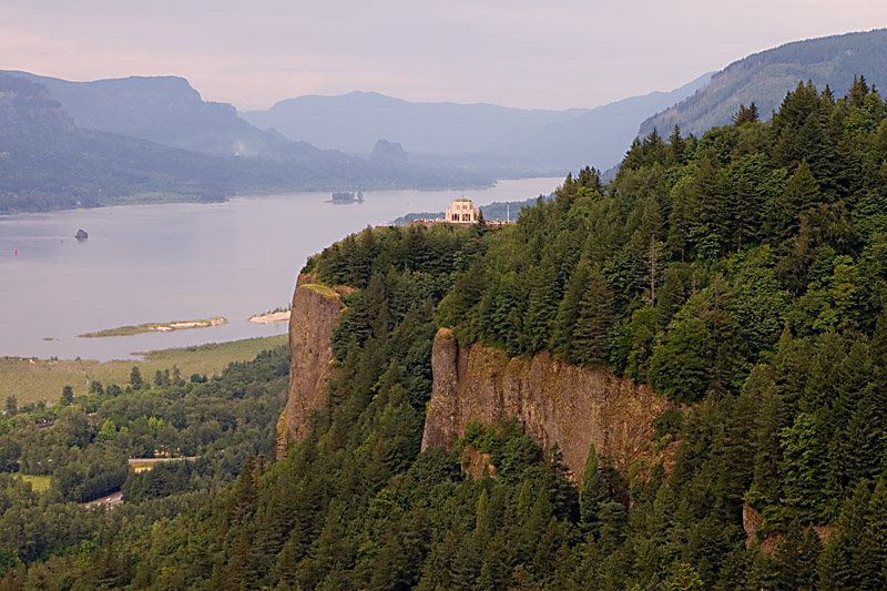 That little cap where the Crown Point Vista House sits is approximately 733 feet above the river. The surface of that area was scoured clean when the floods over-topped the point. Below is a sort of cartoonish, quick graphic to illustrate how the same Google Earth View as above might have looked as the flood crested.
 Likewise for the blued-out photo below:
 I strongly recommend taking the Scenic Gorge Route, the Historic Columbia River Highway, through the western portion of the Gorge, especially if the weather is clear. The unique rectangular valley cross-sections carved by the Missoula Floods is apparent in the unmodified version of the photo, though heavily modified by post-glacial mass movement. Get off the highway at Exit 18, just east of Troutdale, and follow the marker signs- keep an eye out for these; they're not always as apparent as they might be. Stunning waterfalls and vistas await. The map below is a screen capture of a biking map and guide for the gorge. (1.6Mb PDF)
 The Scenic Highway rejoins I-84 at Dodson. If you don't feel like you have time to do the scenic route, at least take time to stop at the Multnomah Falls pull-out. There's a parking area between the east- and west-bound lanes, with a tunnel under the highway and a short walk over to the tallest falls in Oregon. Again, much of the Gorge's scenic beauty can be ascribed to the massive erosive power of the Missoula floods, which steepened the valley walls to nearly vertical for much of the Columbia River's passage through the Cascade Mountains.
As the Columbia River Gorge opens out into the Portland area, the waters slowed and spread out. A particularly notable feature near the mouth of the Gorge is Rocky Butte, right where Interstate 84 merges with I-205; the interchange is in the middle right side of the following Google Earth image. Rocky Butte is a more resistant volcanic core; the less resistant outer layers were removed during the flooding. Note the ridge of sediment extending in the downstream (west or left) direction from the north end of the butte, where the water slowed on the lee side of the butte. As you approach this from the south on 205, you can see an upstream trough carved out by the turbulence created when the flood waters encountered this resistant outcrop.
 Since the floods originated from a glacial collapse, rocks embedded in the ice were carried enormous distances in icebergs. It appears likely that the most famous of these was the Willamette Meteorite. Originally discovered near West Linn, Oregon, it now resides in the American Museum of Natural History in New York. Note that the Wikipedia entry on this (the previous link is preferred) indicates that the meteorite came to the location where it was discovered by glacial transport. Glaciers never came close to that portion of the Willamette Valley floor. A Google search for "Willamette Meteorite" was a little disappointing; much of the information is just wrong, and most of the pages I looked at were incomplete or very narrowly focused on one aspect of this fascinating rock- the largest meteorite ever discovered in the United States.
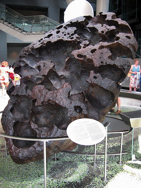 Rocks transported from their original provenance by glacial ice or glacial flooding are called erratics. The floodwaters backed up into the Willamette Valley to a crest elevation of about 400 feet. For comparison, here at my favorite coffee shop, I'm sitting at about 250 feet. Boulders of rocks not native to Oregon have been found all over the valley; the largest is "protected" in a State park, about an hour and a half north of Corvallis, at Erratic Rock State Natural Site. This originally 40-ton boulder has been much reduced by people taking samples; please don't.
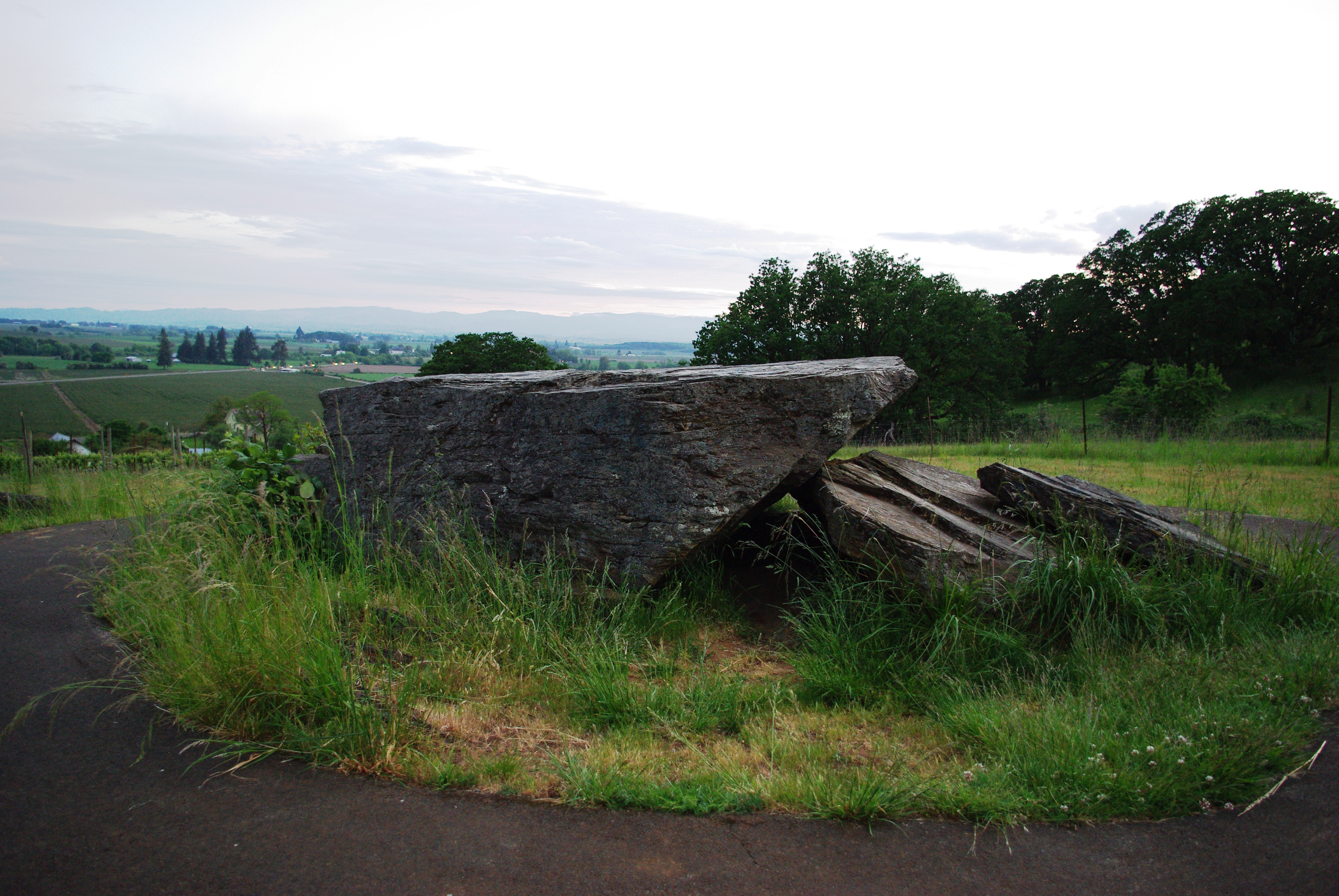 According to Wikipedia,
Geologically, the rock comes from Canada and is the largest glacial erratic rock in the Willamette Valley. The rock is argillite believed to be 600,000 million years old and originally part of the sea-floor. It is also the only rock of its type outside of Canada.It may be from Canada, but I don't know that that is confirmed. It is an argillite, though with sandy (quartzite) interbeds; I think it might be better described as a metmorphosed turbidite, which yes, would have originated on the sea floor. And as I noted above, it is the largest known erratic in the Willamette Valley. It is not the only rock of its type outside of Canada. It is also most certainly not 600 billion years old- that would make it more than 40 times older than the universe. It is, however, large enough to show up in Google Earth satellite imagery. That's it just to the right of the Wikipedia "W," with the paved pathway around it.
 Below is a Google map of how to find it; coming from Corvallis, it's sort of out of the way. I generally tell people that, from here, it's not really worth a trip just for the wayside, but if you're headed that direction anyway, it's well worth the side trip. More impressive than the rock itself is the view out across the valley-look back at the photo for a moment- and contemplating exactly what the rock's presence on the hilltop is telling you.
 This might actually be best on the return to Corvallis, after you have seen some of the more spectacular features created by the floods. Picture a temporary, turbid lake extending out from this hill, filling the valley below you.
This is nothing approaching a complete overview; I know Cliff has done more background research on the scablands than I have, so I really haven't said much about them. But a few pieces that offer a more complete version of the story or other tidbits of interesting info include:
A piece done for the Geoblogosphere's Accretionary Wedge in June.
Another piece for June's wedge- great pictures and LOTS of amazing info.
The USGS paper linked earlier is worth a look.
Congress Rubber Stamps Ice Age Floods National Geologic Trail (This was just confirmed in May)
The Ice Age Floods Institute is the group coordinating the trail effort.
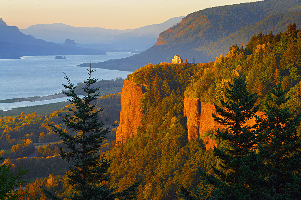
And I'll finish it up with one more photo of Crown Point at sunset. To me, the single most impressive and mind boggling fact I know about these floods is that they overtopped the spot where that building sits. Truly beyond comprehension.


2 comments:
Who are you trying to fool? Jesus did all that shit in under 6000 years and you know it.
Well... 19K to about 12K. So 7000 years. What's a millennium between friends? Anyways, it was his dad who was the geology guy. That jeebus character was too much of a party animal and wino to get all this work done. He just built houses and shit, like Jimmy Carter.
Post a Comment