
On Sunday, I pointed out, "Chert is the lithified remains of countless trillions of silicic shells, or tests, of plankton that have fallen to the sea floor, far from sources of continental clastics." It's that last phrase that's important. "Clastics" is geological shorthand for "broken pieces of pre-existing rock." So a lot of the stuff we're seeing in the photo above, from the boulders on the the stack in the upper middle on the left, to the sand and cobbles making up the tombolo, to the sand on the beach, could all be referred to as clastics. And that would include fragments down to sizes not even visible to the naked eye such as mud and clay. Those can remain suspended in the water column for years before they finally settle out.
The thing is, when clastics are present, and depositing, they tend to completely overshadow and dominate the sedimentary record of biological or chemical sedimentation. Chert contains very little in the way of a clastic component, so it must formed very far from any sources of clastic sediment. Hundreds, perhaps more than a thousand, miles from continental shorelines, which are huge sources of clastic sediment.
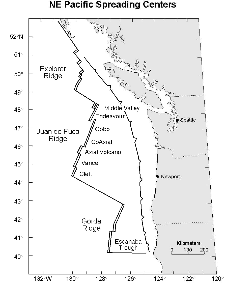
But there's a problem... well, two, really. First, about 70 km (~42 mi) (According to this map, from here, fig. 3) out, we find the Juan de Fuca Subduction Zone. The bigger problem is that about 235 km (~146 mi) out is the Gorda Ridge. These bedded cherts couldn't have been formed within either of those distances, nor could they have possibly moved across the Gorda Ridge from farther out to sea. Quite the puzzle, right?
Not so quick. This chert is part of a larger unit, the Dothan Formation, of late Jurassic to early Cretaceous age. So the plate tectonic boundaries of today tell us very little about its location during that time. It's quite possible- even likely- the Gorda Ridge didn't even exist at that point in time. Slow subduction over (roughly) the last 150 million years or so has consumed the abyssal plain that this rock certainly formed upon, then accreted and crushed it.
I won't say Rainbow Rock "proves" plate tectonics, but it certainly seems to demand it. This was part of the wonder of finally seeing it in person. Despite the risk of being photographically repetitious, I thought that was a worthy way to end Geo 365. So, goodbye Geo 365! It's been fun!
P.S. Stay tuned... I have a few very fun (and hopefully, useful!) extras coming along shortly. This post was drafted 12/30; I'll publish it when I get in today, then polish and finish the others off. They'll be up as soon as I can manage it. Interzone will be closed tomorrow, so I'm hoping I get to see a few reactions before they close at 2 PM. See y'all on the second! Happy New Year!
Photo unmodified. May 8, 2013. FlashEarth location.


3 comments:
It's been a wonderful series, Lockwood, and I'm eager to see how you follow it up.
Happy New Year!!!
Thank you for a geo 365 year. Some wonderful posts and lots of geology education. Now I want to take a trip through Oregon armed with your blog as a resource of where to visit.
Thank you Lockwood. I sure have enjoyed this series. I've learned a lot especially about Oregon. I hope this coming year is better for you than this past year. Happy New year.
Post a Comment