The quake was felt as far south as Capitola in central California, and as far north as Roseburg in central Oregon, USGS geophysicist Richard Buckmaster said.Chris Rowan just posted these images of the area in his blog, Highly Allochthonous, a few days ago. The first shows the overall tectonic setting of western North America:
FRESNO, Calif -- A 6.5 magnitude earthquake struck off the coast of Northern California Saturday afternoon, shaking buildings south of the Oregon border and knocking out power in several coastal communities.
The U.S. Geological Survey said the quake hit at about 4:27 p.m. about 27 miles from Eureka, a city of about 26,000.
The state's warning center hasn't received any reports of injuries or major damage, California Emergency Management Agency spokeswoman Lori Newquist said.
 The spot off of northwestern California where the San Andreas Fault, the Mendocino transform, and the Cascadia "Trench" (Physically, there is no "trench;" it has been filled in with sediment. But there is most certainly a subduction zone) meet is referred to as a triple junction.
The second shows a number of places where the direction of streams has been changed by tectonic deformation, leaving behind "wind gaps," places where stream-carved valleys cut through a hill or ridge, but where there is no longer a stream present. I include this primarily to illustrate where Eureka is: it sits beside Humboldt Bay.
 I don't feel like explaining exactly how these diagrams work just at this moment (bad geology pun alert), but this indicates a strike-slip movement in the quake; as such, it is unlikely to cause a tsunami. This is from the NCSS Moment Tensor Solution page in the USGS science-technical report on this quake.
 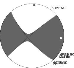 The more general USGS report is here; also on the latter page, you can report your experience if you live in the region and believe you felt the quake. This kind of web-enabled reporting can be very helpful to scientists trying to understand seismicity in earthquake-prone areas.
Actually, it turns out Chris had posted on these weird "beach ball solutions" for earthquakes just three days before the maps above. (Weird looking if you've never had structural geology, at least)
This is a beautiful area; I have visited maybe a half dozen times. Much of its beauty is due to repeated earthquakes just like this one.
Followup, a few minutes later: Andrew Alden at About Geology and Gary Hayes at Geotripper are on this too.


1 comment:
Is the Medicino Transform anything like the Manhattan Transfer? I need to expand my musical horizons.
Post a Comment