Showing posts sorted by date for query lahar. Sort by relevance Show all posts

Wednesday, March 25, 2015

Geo 1095: March 24, Day 813: Dim, Not Bright

...is how this rock made me feel. I recognized the parts, but had no idea of how it could have happened.

Now, to non-geology types, that may not make a whole lot of sense. Here's the thing: all geology is about change. Something changed, or that rock (or land form, or what have you) wouldn't be there, or in that form. What geology struggles to do is to tell stories about what changed, how, and maybe why ("why" in terms of causal mechanisms). Just eyeballing this rock, I roughly estimate the components at pumice (the light, somewhat rounded pebbles about half a centimeter in diameter- the lens cap is 52 mm diameter), 50%, ash (the slightly darker fine material between the pebbles), 40%, and quite a range of mafic to intermediate fragments (the much darker bits) at 10%. Again, that's just a quick and dirty guess. I can tell you what the pieces are, but the point is, what's the story? How was this deposited? It's too-well sorted to be a lahar, but too poorly sorted to be a simple ash fall. What's the deal with those dark pebbles and grit? Where did they come from, and how did they get in there?

The fact of the matter is, I should have been able to recognize the answers to those questions, but there were some features here (notably the dark bits) that I had never seen in such abundance, and some others (notably the well-sorted pumice) I hadn't seen in this form. So when I finally got a look at a similar rock on Twitter, the link clicked immediately. Not knowing "the answer" troubled me, but finding the answer made me understand why I didn't see it to begin with. Learning can be a frustrating process, but reaching a satisfactory conclusion is satisfying, even when accompanied by a mental facepalm. "Oh, of course! Duh!"

Photo unmodified. October 9, 2012. FlashEarth Location.

Monday, March 23, 2015

Geo 1095: March 23, Day 812: Baffling Bedrock

There is talus raveling down the small gullies to the left and upper right, and the base of a larger talus cone in the lower right. Note that most of the plants are rooted in that talus, which can hold small amounts of moisture later into the dry season. In the lower middle of the photo, there are some angular, larger cobbles of rock, which I suspect have fallen from the overlying lahar deposits. The remainder of what is seen here is a fairly light rock, overall, but with many much darker small pebbles. Internally, it's very poorly sorted, but within a narrowly restricted size range, from sand to pebbles in grain size. What this rock represents should have been much more obvious to me than it was, but here's the thing: I'd never seen anything quite like it, and I couldn't get my mind around those darker, more mafic, bits. It looked like a tuff- a solidified ash deposit- but what the heck was going on with the completely different rock types?

Photo unmodified. October 9, 2012. FlashEarth Location.

Saturday, March 21, 2015

Geo 1095: March 20, Day 809: Contact(s)!

There is one very distinct contact in the photo above, between what I've been referring to as the upper unit (lahar deposits), and the lower unit, which, at the time I took the photo, I was assuming were ash deposits of some kind. Turns out, they kind of are, but it's more complicated than I thought, and I only reached a satisfying conclusion a few days ago as to the nature of how they formed.

While I would describe the "upper unit" as poorly sorted overall, there do appear to be several other, though much less certain, contacts that may represent subsequent volcanic debris flows. In the annotation below, the upper-lower unit contact is a solid line, and the tentative contacts within the upper unit are dotted lines.
Photo unmodified. October 9, 2012. FlashEarth Location.

Tuesday, March 17, 2015

Geo 1095: March 16, Day 805: Reverse Grading

On the approach to Tombstone Pass, on Route 20 east of Corvallis, in the Western Cascades, there are a number of appealing roadcuts, some of which have convenient pullouts. Despite having sailed merrily past them many times, I had never had time or opportunity to stop and look more carefully at them prior to a trip to the area with Dana on  October 9, 2012.

Though this was not the droid outcrop I was looking for, it did have some interesting features, and the one I was looking for was just around the corner. And when I say "just," I walked to it in about the same time it took for Dana to move the car there.

Looking at the cut, though, there are a couple of things that pop out immediately. There are two distinct sets of deposits here. From this perspective, the lower one looks fairly homogenous, with a kind of "badlands" morphology (It's even more distinct in the next cut). The upper one consists of angular, poorly sorted clasts ranging from quite fine to very large. However, despite being poorly sorted, there is a distinct trend for the clasts to get larger from the base of that deposit up to maybe 15-20 feet above that line. This is backwards from most examples of graded bedding, where the individual fragments start coarse and become more fine upwards, and thus is called "reverse grading." It indicates that even though deposition was occurring, the energy of the flow was increasing. It's an excellent indicator of a debris flow, and can often be seen in cuts in modern alluvial fans. This one, being composed of volcanic rock, would properly be called a lahar. Here's a crop to show the reverse graded portion more closely:
We didn't cross the road here, so I didn't realize until we went around the corner how puzzled I would be by the lower unit. And in passing, it looks as if there might be a third, finer-grained, and better-bedded third unit, cut into the second, as a "V" near the center of the photo. Note the gap in the larger clasts in that area.

Photo unmodified. October 9, 2012. FlashEarth Location.

Saturday, March 14, 2015

Geo 1095: March 14, Day 803: No Idea

There is no such thing as a "typical" Klamath Mountain roadcut or outcrop... I suppose this is true for most mountain systems, but with familiarity one can picture a relatively few kinds of scenes one might expect to see in a particular range. With the Coast Range, I expect shallow to deep marine terrigenous sediments, or basalt of one kind or another. With the Cascades, lots of lahar deposits, or basalt to andesite of one kind or another. Oregon's Basin and Range? Cenezoic alluvial to lacustrine sediments... oh, and basalt. Lots and lots of basalt. Columbia River Plateau? Duh. Basalt. You get the picture.

The Klamaths are an utter rats' nest that never ceases to amaze me, and which I will never understand, other than in the most rudimentary, basic sorts of ways. It's a mish-mash of pretty much every kind of rock known to man (though lacking metamorphics of higher grade than schist), squarshed, whirled, blended, folded, spindled, and mutilated, often beyond recognizability. Are there faults in this photo? Almost certainly. Are they where they look as if they might be? Maybe, maybe not. And quite possibly in places where they don't look as if they might be.

I feel a little bad posting this panorama, because, as I pointed out in the title, I have no idea. But upon reflection, I realized that it's a good metaphor for my general understanding of the Klamaths: complicated, fascinating, and humbling, in the sense that they make me painfully aware of how much I don't know, but at the same time, proud that I have clearly learned where that line is, when I get to something that's beyond my ken.

Photo unmodified. May 9, 2013. FlashEarth Location. (Pure guesswork on this one... no idea.)

Tuesday, December 9, 2014

Geo 730: December 9, Day 708: Big Berm

Zooming into the leftish-center of yesterday's photo, you can see the large berm formed, I'm supposing, as the lahar mounded up over the river bank as it swung around that bend. It's far enough distant, and I'm uncertain enough about the size of the trees, that I can't even guess at the size of that bank. But it's clearly pretty big.

I get the sense here that much of Mount Hood's flanks are simply big piles of debris that have spalled off summit plugs and domes. That smooth slope, flattening distally, has very little holding it in place other than gravity. When there are heavy precipitation events, and water starts pushing the rubble around, enormous amounts can mobilize all at once. I hope I'm not alone in saying this sight fills me with awe, and increased my respect for volcanoes, even those that tend not to erupt explosively- such as Mount Hood.

Incidentally, the small "boxy" object on the horizon near the center of the photo is the upper ski lodge at the Timberline Ski Area.

Photo unmodified. October 10, 2012. FlashEarth Location.

Monday, December 8, 2014

Geo 730: December 7, Day 706: White River Lahar

Yeah, Mount Hood is in there, too, but Day-um! This was, by a long shot, the most exciting moment of the day for me. The bank shown in the previous post is visible on the far right, and there are some sparse trees below it, which is why I think that bank is unrelated to this particular flow. But to the left of those lower trees... nothing but volcanic rubble. There's not much in the way of reliable scale, but the tops of a couple campers are just sticking up over the berm to the left in the mid-distance. I have seen countless lahar deposits in various settings, but I don't think I've ever seen one this young and fresh. The devastation is stunning. I'll mention the berm at the river bend in the distance in passing, but I have a better shot coming up soon.

Photo unmodified. October 10, 2012. FlashEarth Location.

Saturday, December 6, 2014

Geo 730: December 6, Day 705: River's Edge

This was the scene just as we started across the bridge at White River. Its headwaters are up in that mostly snow-covered valley on Hood's flank. I initially interpreted that line of dead trees at the top of the bank in the lower center as more of those damaged by the 2006 lahar that roared down the valley here. Comparing it to other pictures from this crossing though, I think a better take is that the bank was developed as one or more older debris flows were eroded by the river- perhaps farther by the 2006 event. Subsequent collapse of the loose, unconsolidated rubble exposed and damaged roots, leading to the trees' deaths.

Photo unmodified. October 10, 2012. FlashEarth Location.

Geo 730: December 4, Day 703: Moar Dead Trees

This was a spot where the lahar on the White River inundated the forest floor more heavily, and most of them beyond the few survivors in the mid-ground appear quite dead. This may look like an ecological disaster, but keep in mind, these Douglas firs have evolved along with this volcanic environment for millions of years. They'll rebound, in time, quite well, thank you. There was a terrific blog post a few days ago from Hollis Marriott at In The Company of Plants and Rocks discussing how debris flows (non-volcanic, in that case) create a highly desirable setting for new Doug fir forests to become established.

There was a lot of road work going on this this area, and while we weren't stopped until we got to the bridge, traffic was slow, so it's difficult to estimate just how far we traveled through this damaged forest. It felt like miles, though it might have just been a couple. We still hadn't had a decent view of Mount Hood through the haze and smoke, but we were now up close to pass level, above a lot of it. And then we turned a corner...

Photo unmodified. October 10, 2012. FlashEarth Location (Approximate).

Wednesday, December 3, 2014

Geo 730: December 3, Day 702: Unhealthy Forest

Continuing to drive up toward the pass north of Mount Hood, I suddenly realized we were traveling through a very unhealthy-looking forest. Unlike forests killed off by pine bark beetles (where pretty much all the trees are dead), this one ran the gamut of dead, dying, and damaged trees, with a few looking fairly well off. That, in addition to the long stretch of road work, had me puzzled for a bit. Then something clicked, and I remembered there had been a very damaging lahar in the area some years earlier. (I just checked- it was 2006. See the bottom of this page for a short description and a very impressive photo of the aftermath at the Route 35/Mount Hood Highway Bridge over the White River.) What I hadn't realized until this trip was that the debris flow inundated a large area of forest in the area as well. Burying a tree's roots, for most trees, causes them to slowly suffocate, explaining the problem here.

In the FlashEarth view, you can see why it's called White River, but that's all loose volcanic rubble, not snow. You can also see some post-lahar incision, and how the debris fanned out into the forest when it reached the vicinity of the highway.

Photo unmodified. October 10, 2012. FlashEarth Location (Approximate).

Monday, December 1, 2014

Geo 730: December 1, Day 700: Lava->Lahar

A closer view of the same outcrop as yesterday's shot, showing lahar deposits over grey volcanic rock- likely something in the andesite/dacite range. Given the clean contact- as opposed to a brecciated lava surface, I'm guessing the top of the lava was an erosional surface for a period of time before the lahar deposits were emplaced. Again, the line of alders is a result of water following that contact until it reaches the cut.

Photo unmodified. October 10, 2012. FlashEarth Location (possibly maybe).

Sunday, November 30, 2014

Geo 730: November 30, Day 699: Perched Water

Turning around to look at the outcrop across the road, we see the jointed lava flow overlain by rubbly lahar deposits. I (and others) have mentioned before that alders- the trees growing in a horizontal row across this cut- like to have their feet wet, and a tight cluster like that suggests a concentration of water. See comments 12 and 13 here, and my write up on the "Cheshire Cat outcrop," here, particularly clue #2. So that line of trees tells you that there's a bit more water in that portion of the cut than elsewhere, and that makes perfect sense. The lava, while jointed, is less permeable than the loose lahar deposits, so water tends to flow laterally along that contact until it reaches the surface, and signals its presence by supporting a stand of alders.

Photo unmodified. October 10, 2012. FlashEarth Location (possibly maybe).

Saturday, November 29, 2014

Geo 730: November 29, Day 698: Hood River Highway

Looking up the highway from our impromptu stop on the way up to Mount Hood, you can see the lava flow on the right, with talus raveling down from the overlying lahar deposits. The road crews have added some sturdy fencing as a further barrier to prevent rocks from rolling out into traffic. But just as we saw with the block knocked out of the Jersey barrier recently, that fencing has taken a lot beating from falling debris.

Photo unmodified. October 10, 2012. FlashEarth Location (possibly maybe).

Friday, November 28, 2014

Geo 730: November 28, Day 697: Hood River Rubble

I was not able to get a good, clear photo of the lahar deposits around the river at this stop, but this is the best of them. In the little slice of whitewater right near the center of the shot, you can see some of the rounded boulders that characterize much of the upper stretch of this river. And though it's over exposed, you can see more of the poorly sorted and essentially un-bedded deposits on the far bank. Near the top, it looks as if we're seeing a talus pile from a still higher (though not necessarily younger) lava flow, based on the angular, un-transported nature of the rock, and the consistency of color and apparent composition.

Photo unmodified. October 10, 2012. FlashEarth Location (possibly maybe).

Wednesday, November 26, 2014

Geo 730: November 26, Day 695: School of Hard Knocks

Looking over later photos of this outcrop, I found I'd misremembered it somewhat in yesterday's description- it appears to be a lava flow- likely andesite or similar- overlain by lahar deposits, not simply piles of those debris flows. However, there's still plenty of bouldery, loosely consolidated and poorly sorted debris up above that andesite (?) cliff, and pieces obviously fall out and off frequently. This poor, beaten up Jersey barrier testifies clearly to that.

Photo unmodified. October 10, 2012. FlashEarth Location (possibly maybe).

Tuesday, November 25, 2014

Geo 730: November 25, Day 694: Alluvial Fan

There's a tendency to think of alluvial fans as an arid landscape landform, and they often are. But they can occur anywhere debris flows are a major component of sediment transport. (I almost called the phenomenon "erosion," which technically, debris flows aren't.) And volcanoes generally are highly vulnerable to debris flows; in that setting, they're called "lahars." Volcanoes are steep, catch a lot of precipitation as a result of orographic lift, and often have large amounts of unconsolidated to poorly consolidated rock. It's clearly a setting where saturated ground can fail, leading to a torrent of mud to boulder-sized sediment along with trees, houses, cars, and any furry creatures unfortunate enough to be in the way. I suspect most of what we're seeing in this mini-fan is the result of single rocks and boulders falling down the stream bed- not one or more lahars. As we'll see soon though, this whole area is composed of lahar deposits, young and old.

Followup, 3:33 PM- It just dawned on me, if this pile formed the way I described, it should more accurately be described as a talus cone.

Photo unmodified. October 10, 2012. FlashEarth Location (possibly maybe).

Sunday, August 17, 2014

Geo 730: August 15, Day 592: Plants, Old and New

The new plants are pretty obvious, though browning in the early August heat. The old "plant" is not so obvious, but easy to spot once you know what to look for. See the black splotch in the bedrock, occupying the central portion of the photo? That's a large block of what seems to be permineralized charcoal. About a month ago, I posted a microscopic view of this material. It's weird stuff. The carbon in the charcoal is preserved, unmodified, but all the pore space has been filled with quartz. As a result, the charcoal exposed at the surface will smudge your fingers, but the rock as a whole is hard enough to scratch steel.

Unfortunately, I only have two photos of this terrific outcrop. I think there are two major issues: I've done this trip close to fifty times, so it's all deeply familiar to me. I simply don't think about the necessity of having illustrations for people who *haven't* been here. Also, this is a long, tiring day, and often when I'm tired, I'm just operating on autopilot... I'm not even thinking abut thinking. At any rate, I'll just describe it verbally. At the base of the exposure is lahar deposits, based on the angular nature of the clasts, their volcaniclastic composition, and their extremely poor sorting. There may be a second lahar over the oldest exposed, but the outcrop is weathered enough now that I can't see the possible contact I thought I had identified many years ago. Over that is a clearly water-transported and sorted sandstone, which is a ledge-forming bed about a foot thick. Rarely, you can find permineralized, horizontally oriented, woody fossils, which I take to be roots. Above the sandstone is a thin layer of siltstone, which, if and when you can find it, has abundant plant fossils: leaves that look like alder, some sort of coniferous needles, sticks and twigs, and (very) rarely, seeds, cones and catkins. On top of the silty layer is a ruddy layer that I think is a paleosol, a few inches thick. Above all that, finally, is the rubbly layer containing the charcoal. The cobbles are poorly sorted, but seem better rounded. I'm not sure how to interpret the rock, but I'm suspicious I'm seeing sphereoidal weathering, not transport-related rounding. The blocks of charcoal look as if they're entire tree trunks, and their size- up to several feet in diameter- is consistent with that. For more photos, see Dana's posts, a geologic riddle, and with a better overview of the outcrop, the follow-up answer.

Photo unaltered. August 5, 2012. FlashEarth Location.

Monday, August 4, 2014

Geo 730: August 4, Day 581: Calcite-Filled Fault

This stop has been badly weathered over the years, but it's an interesting one in that it shows a gradient from a more or less unaltered lahar deposit(s) to highly altered near the vein showing above. The vein doesn't stand out well from the surrounding clay-rich material, but it's the diagonal slash in the rock face below the alder tree at the top. This is another stop that rewarded multiple visits; the weathered surface of the unaltered (by hot water) lahar material looks almost indistinguishable from basalt at a cursory glance. However, if you break open a fresh surface, it's pretty easy to tell it's volcaniclastic, not directly volcanic. For years I had told kids it was basalt, and had to change my story when an adult assistant found a bit of petrified wood.

Photo run through Paint.Net's auto-level routine for saturation and contrast. June 19, 2014. FlashEarth location.

Thursday, July 17, 2014

Geo 730: July 16, Day 562: Wood, Ancient and Modern

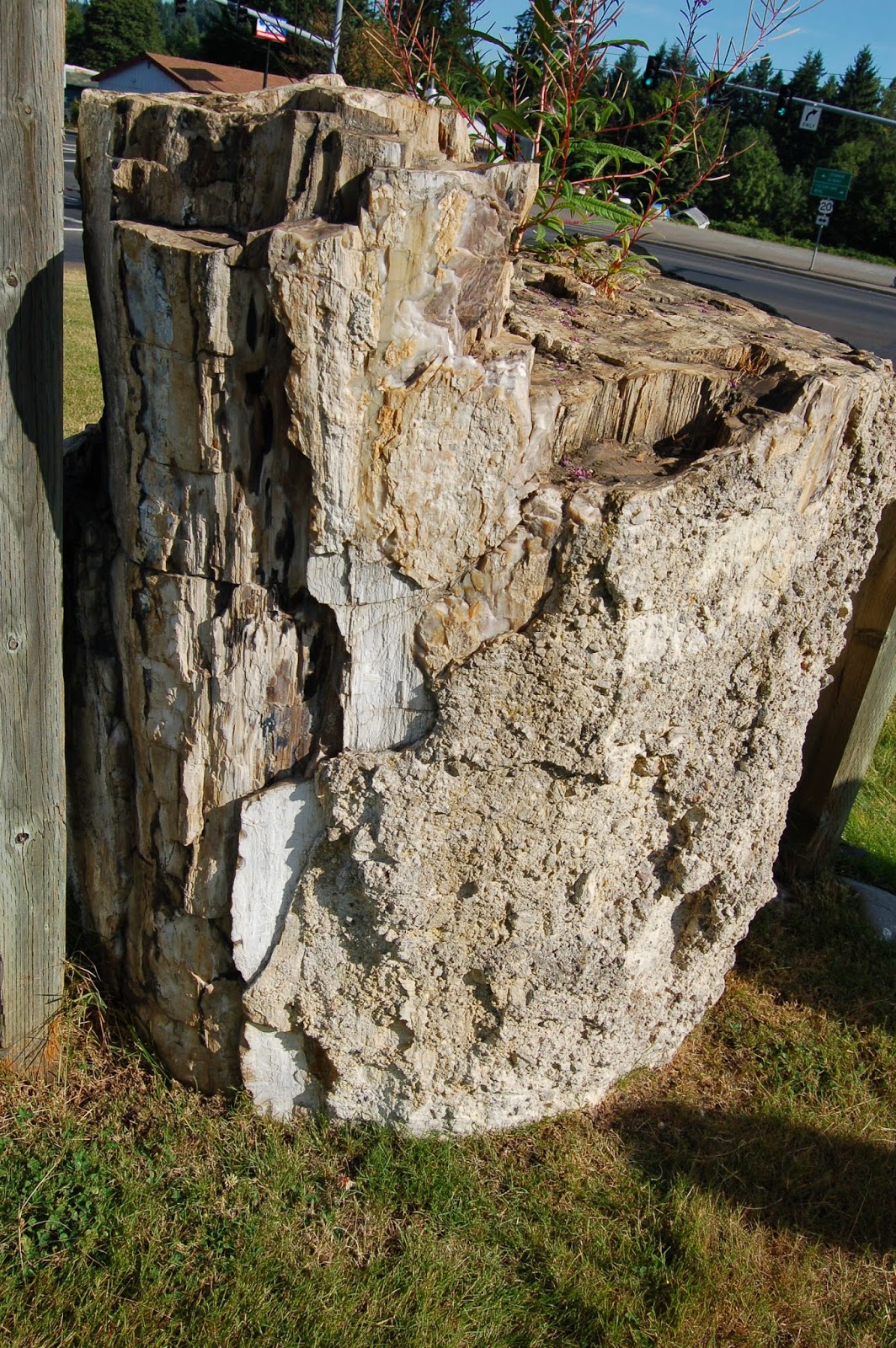
A final shot of the petrified (permineralized, to be technically correct) tree stump closest to the intersection at the Sweet Home Community Museum. On the left side is an example of much younger wood, holding up the protective roof sheltering the stump. Other than the petrified wood itself, there are two features of interest to me.
In the lower right portion of this crop, some of the surrounding rock matrix can be seen, still clinging to the outside of the stump. It's angular, suggesting it wasn't transported far, and poorly sorted, which suggests a debris flow. You can't tell directly from the photo, but I assure you, the clasts are volcanic in origin. So I'd guess the tree was killed and buried in a lahar. Also, in the above right of this crop, and...
...in the middle of this one, there's some very pretty secondary silica, likely chalcedony, a microfibrous form of quartz. Texturally, in the photo at least, it bears some resemblance to opal, which is amorphous hydrated silica. Opal is significantly softer than quartz/chalcedony, and the two forms are not that difficult to tell apart in the field. However, before making a call, I should field-check the material. I'm not comfortable trying to distinguish the two from photos. (Opal has more of a vitreous luster, while chalcedony has a more waxy to flat luster. The above looks more vitreous to me. But the hardness is a more diagnostic feature, and I don't want to test that on my computer screen.)

Photo unmodified. March 9, 2012. FlashEarth location.

Tuesday, July 15, 2014

Geo 730: July 11, Day 557: Stumped Again

Dana stopped by yesterday with her friend B, and we went over to the coast, where it was a blissful relief from the heat here. We mostly revisited stops I've previously covered, but we did hit one new place, Boiler Bay, north of Depoe Bay. It wasn't the greatest geology, but it was awfully pretty, and there were a couple exposures that were quite interesting. I'll get to them in this series eventually. We also went down to the beach at Seal Rock, and saw a *great* contact between CRB and Astoria or Yaquina Formation (some uncertainty what the unit is). Again, I'll get to it sometime.

In the meantime, back to the Sweet Home and Quartzville area. Above is the second petrified stump at the community museum. While you can't get a good look at the grain of the taller one, this one is much shorter, so you can see the broken end and the wood grain very well. The tephra plastered on to the outside is poorly sorted; it looks like this was rapidly buried in a lahar.

Photo unmodified. March 9, 2012. FlashEarth location.