Via
The Bend Bulletin:
In 1507, German cartographer Martin Waldseemueller named a huge land mass in the Western Hemisphere “America,” in honor of Italian navigator Amerigo Vespucci.
Apparently, this is a big day in the history of navigation. From the same link,
In 1859, ground was broken for the Suez Canal.
In 1959, the St. Lawrence Seaway opened to shipping.
From
Wikipedia,
In 1513 Waldseemüller appears to have had second thoughts about the name, probably due to contemporary protests about Vespucci’s role in the discovery and naming of America, or just carefully waiting for the official discovery of the whole northwestern coast of what is now called North America, as separated from East Asia. In his reworking of the Ptolemy atlas, the continent is labelled simply Terra Incognita (unknown land). Despite the revision, 1,000 copies of the world maps had since been distributed, and the original suggestion took hold. While North America was still called Indies in documents for some time, it was eventually called America as well.
I've always been a little curious about how these two continents came to be known as America, rather than Columbia. I mean, I knew where the name came from, but why didn't he choose the actual discoverer as the eponym, rather than a second explorer and writer?
According to the excerpt below, the decision was made because it was Vespucci's observations, not those of Columbus, that made it clear this was an entirely new land:
Apparently among most map-makers until that time, it was still erroneously believed that the lands discovered by Christopher Columbus, Vespucci, and others formed part of the Indies of Asia. Thus some believe that it is impossible that Waldseemüller could have known about the Pacific, which is depicted on his map. The historian Peter Whitfield has theorized that Waldseemüller incorporated the ocean into his map because Vespucci's accounts of the Americas, with their so-called "savage" peoples, could not be reconciled with contemporary knowledge of India, China, and the islands of Indies. Thus, Waldseemüller reasoned, the newly discovered lands could not be part of Asia, but must be separate from it, a leap of intuition that was later proved uncannily precise.
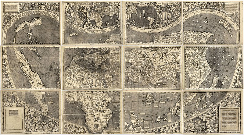
Also
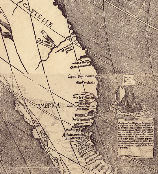
from Wikipedia, the above is apparently the chart under discussion. I love old maps, but the full size image is ginormous, 13,708 × 7,590 pixels, file size: 19.65 MB, and my computer basically choked on it. Below is a crop (from the same page as above) showing our part of the world getting named.


No comments:
Post a Comment