Showing posts with label Geoblogosphere. Show all posts

Monday, May 4, 2015

Geo 1095: May 3, Day 853: Benchmarking With Dana

When I shot with film, each shot ended up costing about a dollar, so each photo was fairly carefully considered as to its value, utility and quality before I snapped the shutter. There are some downsides to digital, but they're all outweighed by the fact that after the initial investment, all the photos are essentially free. So while I took only a couple of film photos of benchmarks, now I'll snap a shot of any that I spot. Here's the McKenzie Pass benchmark, with Dana for scale, and Dee Wright Volcano Observatory in the background. The survey marker is that rusty looking dot near the lower middle, just to the right of Dana's left foot.

Photo unmodified. July 6, 2013. FlashEarth location.

Wednesday, April 29, 2015

Geo 1095: April 29, Day 849: Anne & Chris Again

This is almost a repeat of yesterday's. I try to avoid that by poking around nearby shots before selecting the one I like best. Apparently I didn't do that yesterday, but I like this one better, and they haven't seen it. My blog, my rules. North (closer) and Middle Sisters in the distance.

Photo unmodified. July 6, 2013. FlashEarth location.

Tuesday, April 28, 2015

Geo 1095: April 28, Day 848:Anne, Chris, Dee Wright and (Two of) Three Sisters

After leaving the Deer Creek area, we headed up to McKenzie Pass to take in the views from Dee Wright Volcano Observatory. Here we see Anne and Chris on the upper platform, with North and Middle Sisters as a backdrop on the left. (See this post for all four of our merry band of geotrippers. If you can't tell, that's me on the left and Dana on the right.)

I've already posted a number of panoramas of the views from atop the observatory (See July 9, July 10, and July 12 of the Geo 365 series), so the coming posts will focus on some of the nearer features here.

Photo unmodified. July 6, 2013. FlashEarth location.

Monday, April 13, 2015

Geo 1095: April 13, Day 833: Walk the Plank

I think what Anne was communicating here was "NO!" As in "say next to nothing about this spot!" I prefer to see a head-and-cross-bones, as in "I will walk you off off the plank if you reveal this location." See Saturday's post, if you missed it, for as much information as I'm going to give about this spring.

Photo by Dana Hunter. July 7, 2013. No location.

Saturday, April 11, 2015

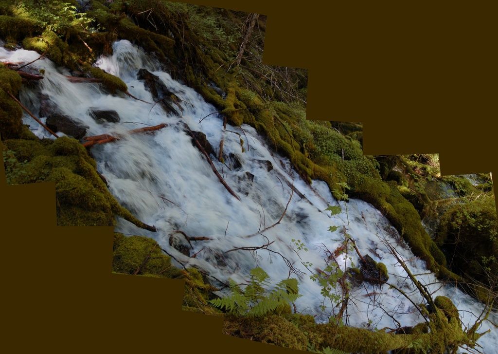
Geo 1095: April 11, Day 831: The Spring Who Shall Not Be Named

This set of shots was an experiment to see if HugIn could cope with a panorama that wasn't composed of more-or-less horizontally or vertically aligned photos. I'm neither entirely pleased nor displeased with it. It works well enough to be interesting. Anne took us to this spot after a solemn vow we wouldn't disclose its location, nor say anything of substance to identify it. There are sound environmental reasons for that, which I won't discuss further, and it's purposely not following my general practice of chronological order. However, it does relate to the hydrology of Clear Lake, so it's relevant following that site.

This spring, on it's own, has a flow that's twice (!) the flow through the Eugene Municipal water system. I don't recall the actual flow rate, but it's on the order of a few cubic meters per second. Now Eugene, the second largest city in Oregon, has an estimated population that's nearly 160,000 people. So this spring by itself releases enough water to supply the needs of a city of about a third of a million.

When lava blocked Clear Lake, about 3000 years ago, the rising water covered numerous springs that emerge in the area. They're still there, just hidden underwater. But I'm told there is an especially voluminous one near the northeast edge of the shore. I'd like to imagine that before it was drowned, this is roughly what it looked like. But maybe even bigger!

Photos stitched in HugIn, empty areas filled in Paint.Net. July 7, 2013. No location.

Friday, April 10, 2015

Geo 1095: April 10, Day 830: Float Your Boat

A final shot, for now, of Clear Lake, this one was taken on the McKenzie hydrology trip with Anne, Chris, and Dana. It was on this trip that Anne showed us some of the wonders that water can pull off in this drainage. In terms of visible water, Clear Lake is where it all begins, but the real story starts across the many, many square miles of recent rubbly lava flows uphill from here. Rain and snowmelt sluices into the fractures, and over a period of years, trickles underground to emerge at this location. I'm particularly fond of this photo, because the boat and the reflection of its passengers are visually confusing. It looks as if the boat is actually floating a foot or so above the water's surface. Of course it isn't, but it's this sort of optical delusion that makes me eschew the dock.

Also, non sequitur sidenote, today is the 200th anniversary of the largest volcanic eruption in human-recorded history: Tambora blew up on today's date in 1815. Here's a post describing it and contemporary observations, from Dr. Skyskull. Here's another discussing Tambora specifically, and large volcanic eruptions generally, in terms of their climatic effects. Lots of new-to-me information in both of those recommended readings. Followup, 4:08 PM: Here's another great read on Tambora from Erik Klemetti, with lots of links for additional reading, on the sheer, mind boggling scale of this eruption. One spoiler: the eruption released energy roughly equivalent to 2.2 million times the amount released in the Hiroshima blast.

Photo unmodified. July 7, 2013. FlashEarth Location.

Friday, February 20, 2015

Geo 1095: February 20, Day 781: Humpty Dumpty

Like Humpty Dumpty, this (now dry) set of pool terraces was as delicate as eggshells. Unlike Humpty Dumpty, it didn't fall off a wall, but rather was trampled by tour groups earlier in the cave's history. You can't see that from the trail now, because happily, also unlike Humpty Dumpty, Park employees, such as internet geology friend @helenasrox and her mother, were able to painstakingly piece it back together again. Somehow, this makes me feel like the hundreds of hours I've spent with jigsaw puzzles weren't entirely wasted.

Photo unmodified. May 9, 2013. FlashEarth Location. (Since we're underground, I have only a vague idea where this is with respect to the surface.)

Wednesday, January 7, 2015

Geo 365/730/1095: Mapping ALL The Geo!

Yesterday, Ron Schott sent me the link and the embed code for his ongoing project to map all the locations in my own ongoing "Geo" series. Theoretically, you should be able to drag and zoom the above map to explore all of the (currently) 736 photos and descriptions in the project. In practice, especially in the Geo 365 set, I frequently reused the exact same lat/lon FlashEarth location for photos in close proximity to one another, which means several "dots" are imposed on a single point, and are not individually resolvable. This past year, I made an effort to shift the location each day, at least slightly, but I suspect that unless you are zoomed in to a high degree, they may still be difficult to resolve individually. If you'd prefer to open this as a full window, which I recommend, the map can be accessed here.

As a reminder, this series was and is not intended to be devoted specifically to Oregon geology- though goodness knows, I've barely scratched the surface here. The focus on Oregon simply reflects the fact that I've spent very little time out of the state since I acquired a digital camera. In Dana's and my geogalvanting over the last four years and a few months, we've just skimmed into northwestern-most California one day, and northwest-most Nevada on another. But we're making planz... heh, heh, heh!

Monday, September 22, 2014

Geo 730: September 22, Day 630: Dana Makes Contact

Jumping ahead a bit in covering our July trip this year, I realized that in the two previous anniversary posts, I should have included at least one photo of Dana. And since this is one of my favorite photos from our recent trip, here you go. Why favorite? Because she's so obviously happy to be here, pointing at the contact above her head, like Vanna White doing a show called "Wheel of Earth History."

But there's some very pleasing geology here, too. Regular readers may remember that in last year's series, I posted a couple of photos of Elephant Rock, at Seal Rock State Park. I was initially frustrated in trying to explain vertical jointing in a vertically tabular sheet of basalt, but I finally generated an idea of how that could happen: it wasn't a dike, as I'd long thought, but an eroded mass that was originally horizontally cylindrical. I couldn't support that with evidence, but it was plausible, and explained those vertical columns.

Now I have evidence! Dana is standing in front of (Miocene) Astoria Formation, and above and to the left of where she's pointing, you can see the lower contact of a Columbia River Basalt flow. AND... it's tilted just as one would expect if that invasive episode was originally cylindrical! (There are also some nice cross-beds in the lower right, but I have better photos of those for later.)

So not only did this make Dana happy, it made me happy, too.

Photo unaltered. July 15, 2014. FlashEarth Location.

Sunday, September 21, 2014

Geo 730: September 21, Day 629: Anniversary Beach

Here we're at Sutton Beach/Creek, a recreation area on Siuslaw National Forest land. We're looking north to the headlands between Florence and Yachats, which are composed of Yachats Basalt, about 35-30 million years old. I've just realized, looking through these photos, that I haven't included many of them from this area on this trip, although I did thoroughly cover a later stop at Cape Perpetua (April 8 to 28 in the Geo 365 Series), about 15 miles north of here. So there's geology in the background, but is there any in the foreground? Yes, though you'd need a bit more context to see that. I chose this photo because I like the dramatically windswept tree, but if I had turned 90 degrees to the left, you'd see a stream and open beach; this area has only been colonized by plants within the past couple of centuries. There's no higher ground between here and the ocean, thus nothing protecting the vegetation from fierce storm winds, which are frequent and persistent in the winter. If you're unfamiliar with the area, this isn't necessarily evident from this photo, but if you have spent any time along the Oregon Coast, this sort of setting has clear implications for the geologic context where it's found. If you want to get a sense of what the solid earth materials are doing, you have to have a strong understanding of what the other earth components- living, liquid and gaseous- are doing, too.

Photo run through Paint.net's AutoLevel routine for contrast and saturation. September 20, 2010. FlashEarth Location.

Saturday, September 20, 2014

Geo 730: September 20, Day 628: Anniversary Tyee

Four years ago today, I met Dana Hunter for the first time. We went up Marys Peak to get a good look at a transect of Oregon's Coast Range Geology. So I'm interrupting the current series in the Newport area for a couple of days. (The following day, we went to Florence and the headlands between Florence and Yachats.) Above, we see steeply dipping beds of Tyee Formation along Route 34, a couple miles east of Alsea Pass. This outcrop is close to the Corvallis Fault; it lies just to the west here, and crosses the Coast Range crest on the west side of Alsea Pass.

Photo unaltered. September 20, 2010. FlashEarth Location.

Friday, August 22, 2014

So You're Going to Bend...

What to do, what to do? The area has a lot of options for people interested in geology, though some require a bit of a drive. In the city itself, Pilot Butte has great views of Bend and the surrounding landscape- in particular, west to the Cascades and south to Newberry. There is a trail to the top, though I can't imagine it's very interesting compared to others in the area, but there's a paved road to the top too, with ample parking. The last time I was there was at sunset, and the glare to the west made it impossible to see the Cascades well. I'd bet it's spectacular at sunrise, and mornings generally are probably better.
Pilot Butte, from Geo 365. (See the Index for more photos and information)

Newberry... *SO* much to do and see. A large portion of this complex was set aside as Newberry Volcano National Monument in 1990. (See up-to date info on fire closures and other alerts, as well as general and contact information at that link) Here are some highlights:

*Lava River Cave- I haven't been to this feature in years, but it's Oregon's longest known lava tube, at a bit over a mile. There's a per-vehicle fee, but I don't know if that's in addition to the general entry fee for the monument (I kinda doubt it, but I'm not sure). Then there's a rental fee for propane lanterns, but that's like a couple bucks and is trivial compared to the value of exploring the cave. The cave itself is a refreshing brisk walk on a hot summer day- a nice escape from a hot summer afternoon, the average temperature is 42 degrees- you'll want a jacket or something fairly heavy and warm.
*Lava Lands Visitor Center- I don't find the visitor center itself all *that* interesting (others less familiar with the area may disagree) but it's an ideal site to get up close and personal with some typical features of the monument. I'd recommend early in the day for this spot. One can drive to the top of Lava Butte, but parking is limited. The center gives free half-hour passes for parking on a first come-first served basis, but on busy summer days, they can go fast. They open at 9 AM. I'd imagine half an hour is plenty of time to walk the loop trail around the summit crater and take in the views.
Lava Butte summit, looking toward Newberry, from Geo 365. (See the Index for more photos and information)

Also at the visitor center, "The Trail of the Molten Land" may have a corny name, but it does show some very cool features of a "breach flow" (my term, don't know if used generally) from a cinder cone.
Lava Balls on The Trail of the Molten Land, from Geo 365. (See the Index for more photos and information)

*Lava Cast Forest- Again, a spot I haven't visited in 15 or 20 years, and a bit out of the way (which means it's not as busy), on a heavily washboarded road. This is exactly what it sounds like: a forest was inundated by lava, and the trees are "preserved" as casts. In other words, they're not there at all, but the space they occupied is represented as void spaces. It's worth it if you have the time.

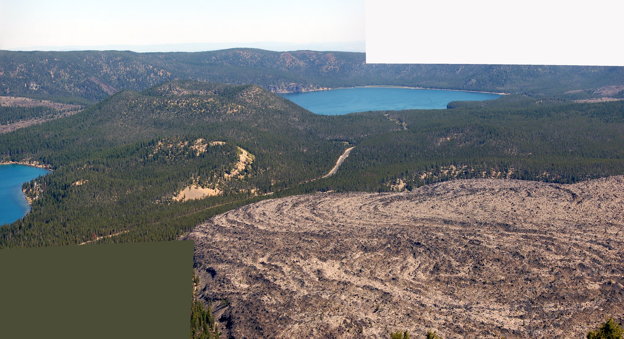
*Newberry Caldera- I suppose if I had to pick just one thing to see in the Bend area, this would be it, though McKenzie Pass is a barely marginal second. Paulina Peak must be one of the most sublime but poorly known vistas in Oregon. The road is rough, narrow, and steep but doable in a sedan... not easy, but doable. For the adventuresome, there is a trail from the caldera floor to the top of the peak, but with a 1620 foot elevation gain, I'm no longer that adventuresome.
Looking into Newberry Caldera from Paulina Peak. Big Obsidian flow lower right, from Geo 365. (See the Index for more photos and information)

More my speed is the roughly one mile Big Obsidian Flow trail, highlighting the features of a stunningly stark pile of broken glass.
Big Obsidian Flow with Paulina Peak in the distance, from Geo 365. (See the Index for more photos and information)

Another spot here, which I haven't visited, but has been recommended to me, is Paulina Creek Falls. I suspect if you choose one of the easier hikes at that link, everything I've listed so far would make a good day (But not if you choose to hike Paulina Peak). However, I've barely scratched the surface in terms of hiking opportunities, focusing more on sights and places I've visited.

Two places I haven't been, but do want to visit sometime, are Cove Palisades State Park, and Smith Rocks State Park. However, the person I know who is actually visiting Bend is planning on some climbing at Smith Rocks, so he probably knows more about that park than I do.

The Headwaters of the Metolius (Wikipedia link, but unfortunately the best link I could find) is a ways west of Sisters, north of Black Butte (The turn-off is just west after you pass the base of this large cinder cone) and it's quite nice, but you're fenced into a relatively small area surrounded by private land, so you can't see much or well. It's frustrating. But this hike looks easy and fun, and a good way to get to know the river better. (I haven't done it, but I should- four miles round trip, fairly flat, I could manage pretty well, I think.)

Finally, as I mentioned earlier, Newberry Caldera just barely squeaks by McKenzie Pass as the number one must-see attraction in the Bend area. Metolius Springs and McKenzie Pass would be an easy, actually, fairly short, day out of Bend, leaving plenty of time for hiking in the Pass area. It looks like Yapoah Crater is a reasonable day hike, if you go after the snow melts back. And I've heard good things about Obsidian Falls. However, I haven't hiked much off-road in this area, so you'll want to track down more information. I found the relatively short (maybe a mile) interpretive trail just to the east of  the observatory to be well done and informative.
"Geobloggers in their natural habitat:" Yours Truly, Anne Jefferson, Chris Rowan and Dana Hunter at Dee Wright Volcano Observatory, McKenzie Pass. (See the Index for more photos and information, and this week in particular has some nice panoramas from the same location. Just ignore July 11 and 13.)

Sunday, August 10, 2014

Geo 730: August 10, Day 587: Volcanic Neck II

Similar perspective compared to yesterday's shot, but with this one, @Geohols has walked into the frame, and her husband has driven their vehicle in as well. This doesn't give a good sense of scale (the truck is still a good 30-40 feet in front of the cliff, so there's a parallax issue), but it does give a better sense. With the pinnacle up on a cliff, and essentially inaccessible as far as I'm concerned, that's the best "for scale" you're going to get with this. Speaking of that cliff, though...

Since I'm standing in almost the exact same spot as yesterday's, the location cross hairs are on the pinnacle, rather than my preferred "where the photo was taken from."

Photo unaltered. June 14, 2014. FlashEarth Location.

Tuesday, December 31, 2013

Geo 365: The Index

For reflections on the process of creating this monster, advice if you decide to try to do something similar, and some other notes, see the following post.

The Index is dedicated to Dana Hunter, dedicated student, quick learner, and the person most responsible for allowing me to take the vast majority of these photos, and revisit- or visit for the first time- most of these spots. Here's to many more trips together!

A'a Lava 1/21, 1/21a, 1/22, 1/23, 1/24, 1/27, 1/28, 1/29, 1/30, 1/31, 2/1, 2/2, 2/3, 4/30, 5/16, 5/17, 5/18, 5/19, 5/20, 5/21, 5/22, 5/23, 5/29, 7/8, 7/9, 7/10, 7/12, 8/24, 9/17, 9/19, 9/20,
Abert Rim/Lake 2/18, 2/19, 2/20, 2/21, 4/2,
Alsea Falls 5/11,
Alsea Spit/Bay 2/4
Andesite/Basaltic Andesite 1/5, 1/6, 7/7, ?2/23, ?9/3, 9/7, 9/8, 9/17, 9/19, 9/20, 9/21, 9/23, 9/25, 9/26, 9/29, 10/4, 10/5, 10/6, 10/7, 10/8, 10/9,?10/10, 10/11, 10/13,
Anderson Springs 10/1,
Angular Unconformities 2/11, 2/13, 7/22, 7/23, 7/24, 8/1, 8/2, 8/3, 8/5, 10/26, 11/13,
Animated Gifs 1/7, 4/4, 4/21, 4/28, 12/2, 12/9,
Annotations 1/24, 1/19, 2/13, 3/8, 5/5, 5/25, 7/9, 7/10, 8/13, 8/15, 8/18, 8/29, 11/17, 11/30, 12/3, 12/21,
Aplite 1/8, 1/9, 1/10, 1/11,
Apatite 1/9, 1/10,
Arch Rock 5/9, 12/17, 12/18, 12/19, 12/20, 12/21, 12/22, 12/23, 12/26, 12/27,
Architectural Geology 2/1, 3/25, 3/26, 3/27, 5/4, 6/15, 10/10, 10/31, 11/1,
Astoria Formation 5/7, 5/12, 6/18, 7/5, 7/15, 7/16, 10/25, 10/26, 10/28,
Bandon, OR 11/6, 11/21, 12/17, 12/18,
Basalt 1/1, 1/2, 1/3. 1/4, 1/12, 1/131/21, 1/21a, 1/22, 1/23, 1/24, 1/25, 1/26, 1/27, 1/28, 1/29, 1/30, 1/31, 2/1, 2/2, 2/3, 2/5, 2/18, 2/19, 2/20, 2/21, 2/22, ?2/23, 2/25, 2/26, 2/27, 3/6, 3/7, 3/8, 3/9, 3/10, 3/13, 3/14, 3/15, 3/16, 3/17, 3/19, 3/21, 3/28, 3/29, 3/30, 3/31, 4/2, 4/3, 4/4, 4/5, 4/6, 4/7, 4/8, 4/9, 4/10, 4/11, 4/12, 4/13, 4/14, 4/15, 4/16, 4/17, 4/19, 4/20, 4/21, 4/22, 4/23, 4/24, 4/26, 4/27, 4/28, 4/29, 4/30, 5/1, 5/2, 5/3, ?5/5, 5/6, 5/7, 5/12, 5/13, 5/14, 5/15, 5/16, 5/17, 5/18, 5/19, 5/20, 5/21, 5/22, 5/23, 5/24, 5/26, 5/27, 5/29, 6/17, 6/18, 6/19, 6/20, 6/21, 6/22, 6/23, 6/27, 6/28, 6/29, 6/30, 7/1, 7/2, 7/3, 7/8, 7/9, 7/10, 7/12, 7/16, 8/13, 8/15, 8/16, 8/17, 8/18, 8/19, 8/20, 8/21, 8/22, 8/23, 8/24, 8/25, 8/26, 8/27, 8/28, 8/29, 8/30, 8/31, ?9/3, 10/24, 10/25, 10/26, 10/27, 10/28, 10/29, 10/30, 10/31, 11/1, 11/2, 11/6, ?12/14,
Basin and Range 1/5, 1/6, 1/14, 1/15, 1/16, 1/17, 1/18, 1/19, 1/20, 2/18, 2/19, 2/20, 2/21, 2/22, 2/23, 2/24, 2/25, 2/26, 10/2,
Belknap Crater 1/25, 1/28, 1/29, 2/2, 7/9, 8/13, 8/18,
Beheaded Glacial Valleys 9/7, 9/10, 9/17, 9/18, 9/27, 10/1, 10/18,
Benchmarks 9/11, 11/19,
Bend, OR 3/25, 3/26, 3/27, 3/28, 3/29, 3/30, 3/31, 4/1, 4/2, 5/13, 5/14, 5/15, 12/25,
Benham Falls 5/22,
Beverly Beach SP 6/18, 7/5,
Big Lake 8/13,
Big Obsidian Flow 5/5, 5/25, 5/26, 5/27, 5/28, 5/29, 5/30, 5/31, 6/1, 6/2, 6/3, 6/4, 6/5, 6/6, 6/7, 6/8, 6/9, 6/10, 6/11, 6/12, 6/13, 6/14, 6/15, 6/16,
Biology-Geology Interactions 1/8, 1/9, 1/15, 1/16, 1/17, 1/21, 1/21a, 1/23, 2/5, 2/6, 2/7, 2/8, 2/9, 2/10, 2/17, 2/18, 2/20, 2/22, 3/5, 3/11, 3/13, 3/14, 3/20, 3/21, 3/22, 3/24, 3/28, 3/31, 4/3, 4/9, 4/13, 4/15, 4/16, 4/18, 4/22, 4/23, 4/24, 4/27, 4/28, 5/1, 5/4, 5/8, 5/9, 5/11, 5/16, 5/17, 5/30, 5/31, 6/126/13, 6/14, 6/23, 7/1, 7/2, 7/7, 7/8, 7/9, 7/10, 7/11, 7/12, 7/15, 7/23, 8/8, 8/13, 8/15, 8/17, 8/18, 8/24, 8/27, 9/1, 9/2, 9/5, 9/6, 9/23, 10/1, 10/5, 10/23, 11/1, 11/3, 11/4, 11/5, 11/7, 11/8, 11/10, 11/22, 11/23, 12/8, 12/9, 12/24, 12/29, 12/30, 12/31,
Bioturbation 7/15,
Black Butte 1/24, 3/30, 7/10, 8/13, 8/15, 8/19,
Black Crater 1/29, 7/10,
Black Smoker 5/7, 10/24,
Bogs 2/7, 11/3, 11/4,
"Breach Flows" 1/21, 1/21a, 1/22, 1/23, 1/24, 4/30, 5/13, 5/16, 5/17, 5/18, 5/19, 5/20, 5/21, 5/22, 5/23, 5/26, 5/27, 8/21, 9/7, 9/8, 9/17, 9/19,
Breached Cones 5/20, 5/26, 5/27,
Breadcrust Texture/Bombs 5/2, 5/3, 8/22,
Breccia 1/27, 4/10, 4/11, 4/12, 4/13, 4/14, 4/15, 4/17, 4/19, 4/20, 4/22, 4/24, 4/26, 4/27, 4/28, 6/10, 6/17, 6/19, 6/21, 10/3, 10/4, 10/5, 10/6, 12/10, 12/11, 12/12, 12/13, 12/14, 12/15,
Broken Top 3/23, 5/13, 5/17, 10/15,
Brookings, OR 5/9, 12/29, 12/30, 12/31,
Brothers Fault Zone 4/2,
Brush Creek 11/22, 11/24, 11/26, 11/27, 11/28,
Calcite 5/8, 5/10, 11/9, 11/16, 11/17, 11/18, 11/26, 11/27, 11/28, 11/29, 11/30, 12/1, 12/2, 12/3, 12/4, 12/5, 12/6, 12/7,
Calderas 1/30, 5/5, 5/25, 5/26, 5/27, 5/28, 5/29, 5/30, 5/31, 6/1, 6/2, 6/3, 6/4, 6/5, 6/6, 6/7, 6/8, 6/9, 6/10, 6/11, 6/12, 6/13, 6/14, 6/15, 6/16, 9/7, 9/8, 9/9, 9/10, 9/13, 9/14, 9/17, 9/19, 9/20, 9/21, 9/22, 9/25, 9/26, 9/27, 9/28, 9/29, 10/12, 10/13, 10/17, 10/18, 10/19,
California 5/9, 12/18,
Cannonball Rock 7/22, 7/25, 7/26,
Cape Arago SP 2/11, 8/8, 12/18,
Cape Blanco SP 5/8, 11/6, 11/7, 11/8, 11/9, 11/10, 11/11, 11/12, 11/13, 11/14, 11/15, 11/16, 11/17, 11/1811/19, 12/17,
Cape Perpetua SP 1/3, 4/7, 4/8, 4/9, 4/10, 4/11, 4/12, 4/13, 4/14, 4/15, 4/16, 4/17, 4/18, 4/19, 4/20, 4/21, 4/22, 4/23, 4/24, 4/25, 4/26, 4/27, 4/28,
Cape Sebastian 12/16,
Cascade Range 1/7, 1/14, 1/15, 1/16, 1/17, 1/18, 1/19, 1/20, 1/21, 1/21a, 1/22, 1/23, 1/24, 1/25, 1/26, 1/27, 1/28, 1/29, 1/30, 1/31, 2/1, 2/2, 2/3, 2/4, 3/23, 3/24, 3/30, 4/1, 5/5, 5/11, 5/13, 5/14, 5/15, 5/17, 5/20, 5/22, 5/23, 5/28, 6/15, 6/24, 6/25, 6/26, 7/7, 7/8, 7/9, 7/10, 7/11, 7/12, 7/14, 8/12, 8/13, 8/14, 8/15, 8/16, 8/17, 8/18, 8/19, 8/20, 8/21, 8/22, 8/23, 8/24, 9/1, 9/2, 9/3, 9/4, 9/5, 9/6, 9/7, 9/8, 9/9, 9/10, 9/11, 9/12, 9/13, 9/14, 9/15, 9/16, 9/17, 9/18, 9/19, 9/20, 9/21, 9/22, 9/23, 9/24, 9/25, 9/26, 9/27, 9/28, 9/29, 9/30, 10/1, 10/2, 10/3, 10/4, 10/5, 10/6, 10/7, 10/8, 10/9, 10/10, 10/11, 10/12, 10/13, 10/14, 10/15, 10/16, 10/17, 10/18, 10/19, 12/25,
Cascadia Subduction Zone/Quake 1/4, 2/4, 5/8, 7/23, 7/24, 10/20, 10/29, 10/30, 11/6, 11/24, 12/24,
Cavernous Weathering 3/5, 3/13, 3/14, 4/177/29, 7/30, 7/31, 8/1, 8/2, 8/3, 8/4, 8/5,
Cave Junction, OR 5/9, 5/10,
Central Cinder Cone 5/5, 5/26, 5/27,
Charleston, OR 2/11, 7/31, 8/4,
Chert 5/9, 12/29, 12/30, 12/31,
Chilled Margins 1/8, 4/17, 4/19, 4/20, 5/9,
China Hat 3/12, 5/5, 5/25,
Chip Ross CP 1/2,  
Cinder Cones 1/21a, 1/23, 1/24, 1/25, 1/26, 1/30, ?3/12, 3/28, 3/29, 3/30, 3/31, 4/1, 4/2, 4/29, 4/30, 5/1, 5/2, 5/3, 5/4, 5/5, 5/13, 5/14, 5/15, 5/16, 5/17, 5/18, 5/19, 5/20, 5/21, 5/22, 5/23, 5/24, 5/25, 5/26, 5/27, 5/29, 6/13, 6/15, 7/8, 7/10, 7/12, 8/12, 8/13, 8/15, 8/16, 8/17, 8/18, 8/19, 8/20, 8/21, 8/22, 8/23, 8/24, 9/5, 9/7, 9/8, 9/16, 9/17, 9/19, 9/20, 9/25, 9/26, 9/29, 10/19, 12/25,
Clay 2/6, 3/6, 9/5,
Clear Lake 1/211/21a, 1/22, 1/23, 1/25, 1/26, 8/15, 8/16, 8/17, 8/24,
Cleetwood Cove 9/13,
Cleowox Lake 5/8, 11/5,
Cloudcap  10/17,
Coaledo Formation 2/11, 2/12, 2/13, 2/14, 2/15, 2/16, 2/17, 7/22, 7/23, 7/24, 7/25, 7/26, 7/27, 7/28, 7/29, 7/30, 7/31, 8/1, 8/2, 8/3, 8/4, 8/5, 8/6, 8/7, 8/8, 8/9, 8/10, 8/11, 12/24,
Coast Range 1/1, 1/2, 1/3, 1/4, 1/8, 1/9, 1/10, 1/11, 1/12, 1/13, 2/4, 2/5, 2/6, 2/7, 2/8, 2/9, 2/10, 2/11, 2/12, 2/13, 2/14, 2/15, 2/16, 2/17, 4/3, 4/4, 4/5, 4/6, 4/7, 4/8, 4/9, 4/10, 4/11, 4/12, 4/13, 4/14, 4/15, 4/16, 4/17, 4/18, 4/19, 4/20, 4/21, 4/22, 4/23, 4/24, 4/25, 4/26, 4/27, 4/28, 5/6, 5/7, 5/8, 5/11, 5/12, 6/17, 6/18, 6/19, 6/20, 6/21, 6/22, 6/23, 6/24, 6/25, 6/26, 6/27, 6/28, 6/29, 6/30, 7/1, 7/2, 7/3, 7/4, 7/5, 7/6, 7/13, 7/14, 7/15, 7/16, 7/17, 7/18, 7/19, 7/20, 7/21, 7/22, 7/23, 7/24, 7/25, 7/26, 7/27, 7/28, 7/29, 7/30, 7/31, 8/1, 8/2, 8/3, 8/4, 8/5, 8/6, 8/7, 8/8, 8/9, 8/10, 8/11, 8/25, 8/26, 8/27, 8/28, 8/29, 8/30, 8/31, 10/20, 10/21, 10/25, 10/26, 10/27, 10/28, 10/29, 10/30, 10/31, 11/1, 11/2, 11/3, 11/4, 11/5, 11/6, 11/21, 12/24,
Collier Flow 7/7,
Columbia River Basalt 1/4, 2/18, 2/19, 2/20, 2/21, 4/3, 4/4, 4/5, 4/6, 4/7, 5/6, 5/7, 5/12, 6/17, 6/18, 6/19, 6/20, 6/21, 6/22, 6/23, 6/27, 6/28, 6/29, 6/30, 7/1, 7/2, 7/16, 10/25, 10/26, 10/27, 10/28, 10/29, 10/30, 10/31, 11/1, 11/2,
Columnar Joints 1/3, ?4/5, ?4/6, ?4/7, 4/11, 4/17, 4/19, 4/20, 6/30, 7/1, 7/2, 7/3, 7/4, 7/5, 7/14,
Compass Rose 4/1,
Conchoidal Fracture 3/25, 3/26, 3/27, 6/4, 6/7, 6/15, 9/23,
Concretions 7/22, 7/24, 7/25, 7/26, 7/28, 7/30, 7/31, 8/1, 8/2, 8/3, 8/4, 8/11,
Conglomerate 11/22, 11/25, 11/26, 11/27, 11/3012/2, 12/3, 12/6, 12/7,
Conjugate Faults 12/19, 12/20, 12/21, 12/22,
Coos Bay, OR 2/5, 11/6,
Coos River 2/5,
Cores  6/27, 7/17, 7/18, 7/19, 7/20, 7/21,
Corvallis, OR 1/1, 1/2, 5/8, 5/11, 6/24, 6/25, 7/11,
Corvallis Fault 1/2, 5/8, 5/11, 6/24, 6/25,
Crater Lake 9/7, 9/8, 9/9, 9/10, 9/13, 9/14, 9/17, 9/19, 9/20, 9/21, 9/22, 9/25, 9/26, 9/27, 9/28, 9/29, 10/12, 10/13, 10/17, 10/18, 10/19,
Crater Lake NP 4/1, 9/1, 9/2, 9/3, 9/4, 9/5, 9/6, 9/7, 9/8, 9/9, 9/10, 9/11, 9/12, 9/13, 9/14, 9/15, 9/16, 9/17, 9/18, 9/19, 9/20, 9/21, 9/22, 9/23, 9/24, 9/25, 9/26, 9/27, 9/28, 9/29, 9/30, 10/1, 10/2, 10/3, 10/4, 10/5, 10/6, 10/7, 10/8, 10/9, 10/10, 10/11, 10/12, 10/13, 10/14, 10/15, 10/16, 10/17, 10/18, 10/19,
Cross-Bedding 1/14, 1/15, 2/9, 3/1, 3/2, 4/9,
Dacite ?9/3, 9/12, 9/13, 9/18, ?9/23, 9/25, 9/26, 9/29,
Darlingtonia Wayside SP 2/7, 11/3, 11/4,
Dee Wright Volcano Observatory 1/31, 2/1, 2/2, 2/3, 7/8, 7/9, 7/10, 7/12,
Delta ?3/18, 11/6, ?11/10, 11/12,
Depoe Bay, OR 10/30,
Deschutes River 3/24, 5/22,
Devils Backbone 9/18, 9/25, 9/26, 9/29,
Devils Churn 1/3, 4/8, 4/10, 4/11, 4/12, 4/13, 4/14,
Devils Punchbowl 5/6, 5/7, 5/12, 7/15, 7/16, 10/25, 10/26,
Diabase 1/2, 1/8, 1/9, 1/10, 1/115/11, 6/25,
Diagrams/Maps 1/25, 2/2, 2/24, 3/14, 3/20, 11/11,
Diamond Peak 9/16, 9/24,
Diatomite 1/15, 1/16, 1/17, 1/18, 1/19, 1/20,
Dikes/Dikelets 1/3, 1/8, 1/9, 1/10, 4/3, 4/4, 4/5, 4/6, 4/7, 4/10, 4/11, 4/12, 4/13, 4/15, 4/17, 4/19, 4/20, 4/23, 5/6, 5/7, 5/12, 7/16, 8/25, 8/26, 8/27, 8/28, 8/29, 8/30, 8/31, 9/18, 9/25, 10/17, 10/25,
Disconformities 2/28, 3/1, 3/2, 3/8, 8/6,
Doherty Grade 1/5, 1/6,
Dothan Formation 12/29, 12/30, 12/31,
Dunes 2/4, 2/5, 2/6, 2/7, 2/8, 2/9, 2/10, 3/11, 4/9, 5/8, 11/3, 11/4, 11/5,
Dutton Cliff 9/21, 9/27, 10/18,
Dutton Ridge 10/1, 10/2,
Earth-Human Interactions 1/4, 1/12, 1/13, 1/31, 2/3, 2/4, 2/18, 3/14, 3/17, 3/25, 3/26, 3/27, 4/18, 4/22, 5/7, 5/10, 6/15, 6/23, 6/30, 8/21, 8/22, 8/23, 8/25, 8/26, 8/27, 8/28, 8/29, 8/30, 8/31, 9/11, 10/20, 10/21, 10/22, 10/25, 10/29, 10/30, 10/31, 11/1, 11/7, 11/20, 11/21, 11/24, 12/8, 12/9, 12/10, 12/24,
Eagle Crags 9/21, 10/12, 10/13, 10/18,
Eagle Point 9/21,
East Lake 5/5, 5/26, 5/27,
"East Side Apron" 1/18, 3/23, 3/24, 3/30, 5/14, 10/16,
Eddyville, OR 7/4, 7/17, 7/18, 7/19, 7/20, 7/21,
Eel Creek 2/8, 2/9, 2/10,
Elephant Rock 4/5, 4/6, 4/7,
Elk City, OR 8/25,
Erosion 1/1, 1/7, 2/6, 2/11, 2/12, 2/13, 2/14, 2/15, 2/16, 2/17, 2/28, 3/1, 3/2, 3/3, 3/8, 3/13, 3/14, 3/15, 3/16, 3/17, 3/18, 3/244/3, 4/4, 4/5, 4/6, 4/7, 4/8, 4/9, 4/10, 4/11, 4/12, 4/13, 4/14, 4/15, 4/17, 4/18, 4/19, 4/20, 4/21, 4/23, 4/24, 4/26, 4/27, 4/28, 5/6, 5/7, 5/8, 5/9, 5/11, 5/12, 5/14, 5/15, 5/17, 5/22, 5/28, 6/18, 6/19, 6/20, 6/21, 6/22, 6/23, 6/28, 6/29, 7/1, 7/2, 7/4, 7/5, 7/6, 7/7, 7/8, 7/9, 7/10, 7/11, 7/12, 7/15, 7/16, 7/21, 7/22, 7/23, 7/24, 7/25, 7/26, 7/27, 7/28, 7/29, 7/30, 7/31, 8/1, 8/2, 8/3, 8/4, 8/5, 8/6, 8/7, 8/8, 8/11, 8/12, 8/15, 8/20, 8/23, 8/31, 9/210/3, 10/4, 10/5, 10/6, 10/7, 10/8, 10/9, 10/10, 10/11, 10/14, 10/15, 10/16, 10/25, 10/26, 10/28, 10/29, 10/30, 10/31, 11/1, 11/6, 11/7, 11/8, 11/9, 11/10, 11/11, 11/12, 11/13, 11/20, 11/21, 11/22, 11/25, 11/26, 11/27, 11/28, 12/11, 12/12, 12/13, 12/14, 12/15, 12/16, 12/17, 12/18, 12/19, 12/20, 12/21, 12/22, 12/23, 12/24, 12/26, 12/27, 12/28, 12/29, 12/30, 12/31,
Estuaries 2/4, 10/20, 11/14,
Evaporites 2/20, 3/19,
Fault/Fault-Line Escarpments 1/2, 1/5, 1/6, 1/21a, 1/241/25, 1/26, 2/18, 2/19, 2/20, 2/21, 2/22, 2/23, 2/24, 2/25, 2/26, 3/18, 3/30, 5/11, 6/24, 6/25, 6/26, 7/10, 8/13, 8/15, 8/16, 8/17, 8/18, 8/19, 10/2,
Faults 1/2, 1/3, 1/5, 1/6, 1/17, 1/18, 1/19, 1/20, 1/21a, 1/24, 1/25, 1/26, 2/11, 2/13, 2/17, 2/18, 2/19, 2/20, 2/21, 2/22, 2/23, 2/24, 2/25, 2/26, 3/1, 3/4, 3/5, 3/7, 3/8, 3/9, 3/19, 3/21, 3/30, 4/24/8, 4/10, 4/11, 4/12, 4/13, 4/14, 4/23, 5/5, 5/9, 5/11, 5/26, 5/27, 6/24, 6/25, 6/26, 7/6, 7/10, 7/13, 7/16, 8/5, 8/8, 8/9, 8/13, 8/15, 8/16, 8/17, 8/18, 8/19, 8/21, 8/23, 10/2, ?10/25, 11/6, 11/11, 11/15, 11/16, 11/17, ?11/25, 11/26, 11/27, 11/28, 11/29, 11/30, 12/1, ?12/5, ?12/6, ?12/7, 12/13, 12/14, 12/17, 12/18, 12/19, 12/20, 12/21, 12/22, 12/23, 12/24,
Feldspar 2/6,
Fish Lake 1/23, 1/25, 8/15,
Flow Banding 6/4, 6/6, 6/7, 6/8, 6/9, 6/10, 6/11,
Flournoy Formation 7/4, 7/6, 7/13,
Florence, OR 2/5, 2/7, 11/3, 11/4, 11/5,
Fluvial Processes/Landforms 1/7, 1/11, 1/21, 1/21a, 1/22, 1/25, 1/26, 1/27, 2/7, 3/18, 3/24, 4/24, 4/26, 5/9, 5/11, 5/22, 7/4, 7/6, 7/11, 8/3110/3, 10/4, 10/5, 10/6, 10/7, 11/6, ?11/10, ?11/11, 11/12, 11/13, 11/14, 11/16, 11/21, 11/26, 11/27,
Folds 1/14, 5/9, 5/10, 6/6, 6/7, 6/8, 6/9, 6/11, 7/6, 7/13, 7/27, 8/8, 8/10, 11/11, 11/30, 12/1, 12/2, 12/3, 12/17, 12/29, 12/30, 12/31,
Fort Rock 3/12, 3/13, 3/14, 3/15, 3/16, 3/17, 3/19, 5/24,
Fort Rock-Christmas Lake Valley 2/26, 3/113/12, 3/13, 3/14, 3/16, 3/17, 3/18, 5/24,
Gabbro 5/9,
Garnierite 5/10,
Geobloggers 1/2, 1/9, 1/10, 1/15, 2/12, 2/20, 3/7, 3/19, 4/2, 4/12, 4/22, 4/27, 5/7, 5/10, 5/22, 5/28, 6/1, 6/5, 6/15, 6/28, 7/3, 7/4, 7/5, 7/8, 7/14, 7/17, 7/18, 7/19, 7/21, 8/1, 8/2, 8/4, 9/29, 10/11, 10/17, 10/22, 11/10, 11/14, 12/5, 12/11, 12/24,
Geologic Hazards 1/4, 2/4, 2/23, 3/4, 5/7, 10/20, 10/21, 10/22, 10/29, 10/30, 11/24, 12/10, 12/24,
Geopetal Structures 2/14, 2/15, 2/16, 2/28, 3/1, 3/2, 3/8, 8/6, 8/7, 11/25, 11/30, 12/3,
Glacial Processes/Landforms 1/23, 1/30, 3/23, 2/2, 5/14, 5/15, 5/17, 5/28, 7/7, 7/8, 7/9, 7/10, 7/12, 8/13, 8/14, 8/18, 8/19, 8/23, 9/2, 9/10, 9/18, 9/21, 9/24, 9/27, 9/30, 10/1, 10/14, 10/15, 10/18, 11/14, 11/16,
Glass Butte 3/25, 3/26, 3/27,
Gold Beach, OR 5/9, 11/21, 12/10, 12/11, 12/12, 12/13, 12/14, 12/15,
Grants Pass, OR 5/9,
Gravel 6/20, 6/22, 6/23, 6/28, 6/29, 8/30, 11/9, 11/10, 11/11, 11/12, 11/19, 11/25, 11/26, 11/2711/3012/2, 12/3, 12/6, 12/7, 12/11, 12/12, 12/13, 12/14, 12/15,
Green Ridge 1/24, 3/30, 7/10, 8/13, 8/19,
Greywacke 11/9, 11/13, 11/14, 11/15, 11/16, 11/17, 11/18, 11/19,
Ground Water 1/211/21a, 1/22, 1/23, 1/25, 1/26, 1/27, 1/29, 2/6, 2/7, 3/14, 3/19, 3/20, 4/26, 5/10, 5/31, 6/12, 8/15, 8/16, 8/24, 9/1, 10/1, 11/3, 11/4, 11/5,
Guano Valley 1/5, 1/6,
Harlan, OR 8/25,
Hatfield Marine Science Center 5/6, 5/7, 10/20, 10/21, 10/22, 10/23, 10/24, 10/25,
Hayrick Butte 1/21a, 1/25, 8/13, 8/19,
High Cascades Graben 1/21, 1/23, 1/24, 1/25, 1/26, 3/30, 7/10, 8/13, 8/15, 8/16, 8/17, 8/18, 8/19, 8/24,
High Lava Plains 2/25, 2/26, 2/27, 2/28, 3/1, 3/2, 3/3, 3/4, 3/5, 3/6, 3/7, 3/8, 3/9, 3/10, 3/11, 3/12, 3/13, 3/14, 3/15, 3/16, 3/17, 3/18, 3/19, 3/20, 3/21, 3/22, 3/23, 3/24, 3/25, 3/26, 3/27, 3/28, 3/29, 3/30, 3/31, 4/1, 4/2, 4/29, 4/30, 5/1, 5/2, 5/3, 5/4, 5/5, 5/13, 5/14, 5/15, 5/16, 5/17, 5/18, 5/19, 5/20, 5/21, 5/22, 5/23, 5/24, 5/25, 5/26, 5/27, 5/28, 5/29, 5/30, 5/31, 6/1, 6/2, 6/3, 6/4, 6/5, 6/6, 6/7, 6/8, 6/9, 6/10, 6/11, 6/12, 6/13, 6/14, 6/15, 6/16, 10/16, 12/25,
Hillman Peak 9/15, 9/18, 9/26, 10/19,
Hiouchi, CA 5/9,
Hogg Rock 8/13, 8/19,
Hole in the Ground 3/18, 3/19, 3/20, 3/21, 3/22, 4/29, 5/1,
Honeyman SP 5/8, 11/5,
Hoodoo Butte 1/21a, 1/25, 8/13, 8/19,
Hornfels 5/7, 8/258/26, 8/27, 8/28, 8/29, 8/30,
Horst and Graben Structures 1/5, 1/6, 1/18, 1/19, 1/23, 1/24, 1/25, 2/2, 2/18, 2/19, 2/20, 2/21, 2/22, 2/23, 2/24, 2/25, 2/26, 3/7, 3/8, 3/30, 7/10, 8/13, 8/15, 8/16, 8/18, 10/2,
Humbug Mountain 4/27, 5/8, 11/20, 11/22, 11/23, 11/24, 11/25, 11/26, 11/27, 11/28, 11/29, 11/30, 12/1, 12/212/3, 12/4, 12/5, 12/6, 12/7, 12/14,
Humbug Mountain Conglomerate 11/22, ?11/25, 11/26, 11/27, 12/6, 12/7, 12/14,
Humor 1/31, 2/10, 4/1, 4/3, 5/15, 10/8, 12/8,
Hydrothermal Alteration 5/7, 8/14, 10/3, 10/4, 10/5, 10/6, 10/7, 10/8, 10/9, 10/10, 10/11,
Ichnofossils/Ichnology 5/4, 7/15, 11/10,
Ignimbrites  10/3, 10/4, 10/5, 10/6, 10/7, 10/8, 10/9, 10/10, 10/11,
Imbrication 11/10, 11/13,
Interlake Obsidian Flow 5/5, 5/26, 5/27,
Interpretive Signs 1/6, 2/3, 1/25, 2/18, 2/24, 1/25, 4/1, 5/7, 6/15, 8/12, 10/20, 11/8, 11/24,
Intrusive Igneous Rocks 1/1, 1/2, 1/8, 1/9, 1/10, 1/11, 4/3, 4/4, 4/5, 4/6, 4/7, 4/10, 4/11, 4/12, 4/13, 4/15, 4/17, 4/19, 4/20, 4/23, 5/6, 5/7, 5/9, 5/10, 5/11, 5/12, 6/25, 8/25, 8/26, 8/27, 8/28, 8/29, 8/30, 8/31, 9/18, 9/25, 10/25,
Iron Mountain 8/15,
Invasive Dikes 4/3, 4/4, 4/5, 4/6, 4/7, 5/6, 5/7, 5/12, 10/25, 10/28,
Inverted Topography 11/12,
Joints 1/3, 1/12, 1/13, 3/1, 3/3, 3/5, 4/5, 4/6, 4/7, 4/11, 4/12, 4/13, 4/17, 4/19, 4/20, 4/23, 5/9, 5/11, 6/17, 6/19, 6/27, 6/28, 6/29, 6/30, 7/1, 7/2, 7/3, 7/5, 7/13, 7/18, 7/27, 11/18, 11/29, 11/30, 12/1, 12/2, 12/3, 12/4, ?12/5, ?12/6, ?12/7, 12/12, 12/13, 12/14,
Josephine Ophiolite 5/9, 5/10,
Juan de Fuca Plate/Ridge 5/7, 5/8, 7/14, 7/24, 10/20, 10/24, 11/6,
Kerr Notch 9/7, 9/10, 9/17, 9/21, 9/27, 10/1, 10/12, 10/13, 10/18,
Kerr Valley 10/1, 10/2, 10/3, 10/4, 10/5, 10/6, 10/7, 10/8, 10/9, 10/10, 10/11, 10/12, 10/13, 10/18,
Kipukas 1/21a, 2/2, 7/9, 7/12,
Klamath Basin 1/14, 1/15, 1/16, 1/17, 1/18, 1/19, 9/22, 10/2,
Klamath Mountains 5/8, 5/9, 5/10, 7/4, 7/6, 7/13, 11/6, 11/7, 11/8, 11/9, 11/10, 11/11, 11/12, 11/13, 11/14, 11/15, 11/16, 11/17, 11/18, 11/19, 11/20, 11/21, 11/22, 11/23, 11/24, 11/25, 11/26, 11/27, 11/28, 11/29, 11/30, 12/1, 12/2, 12/3, 12/4, 12/5, 12/6, 12/7, 12/8, 12/9, 12/10, 12/11, 12/12, 12/13, 12/14, 12/15, 12/16, 12/17, 12/18, 12/19, 12/20, 12/21, 12/22, 12/23, 12/26, 12/27, 12/28, 12/29, 12/30, 12/31
Koosah Falls 1/26, 1/27,
Lake Chewaucan 2/18, 2/19, 2/20, 2/21,
Lakes/Lacustrine Environments 1/14, 1/15, 1/16, 1/17, 1/18, 1/19, 1/20, 1/21, 1/21a, 1/22, 1/23, 1/25, 1/26, 2/18, 2/19, 2/20, 2/21, 2/22, 2/23, 2/24, 2/25, 2/26, 2/27, 2/28, 3/1, 3/2, 3/3, 3/4, 3/5, 3/6, 3/7, 3/8, 3/9, 3/10, 3/13, 3/14, 3/15, 3/16, 3/17, 3/18, 5/5, 5/8, 5/24, 5/26, 5/27, 5/28, 5/31, 6/15, 8/13, 8/15, 8/16, 8/24, 9/7, 9/8, 9/9, 9/10, 9/13, 9/14, 9/17, 9/19, 9/20, 9/21, 9/22, 9/25, 9/26, 9/27, 9/28, 9/29, 10/12, 10/13, 10/17, 10/18, 10/19, 11/5,
La Pine, OR/SP 3/23, 3/24,
Lava - See Volcanoes/Volcanic Rock
Lava Balls 5/18, 5/19, ?6/5,
Lava Butte 3/31, 4/29, 4/30, 5/1, 5/2, 5/3, 5/4, 5/5, 5/13, 5/14, 5/15, 5/16, 5/17, 5/18, 5/19, 5/20, 5/21, 5/22, 5/23, 5/26, ?12/25,
Lava Gutters 1/28, 2/3, 5/16, 5/20, 5/22, 7/12,
Lava Lake 1/23, 1/25, 8/15,
Lava Shelf 10/24,
Lebanon, OR 7/11,
Lignite 1/15, 1/16, 1/17, 1/18, 1/19, 1/20,
Little Belknap Crater 2/2, 7/9,
Little Nash Crater 1/21a, 1/25, 8/21, 8/22, 8/23,
Llao Rock 9/12, 9/13, 9/18, 9/25, 9/26, 9/29,
Maars 3/19, 3/20, 3/21, 3/22,
Marble 5/10,
Marine Terraces- See Wave-Cut Terraces
Marys Peak 1/1, 1/8, 1/9, 1/10, 1/11, 1/12, 1/13, 5/8, 5/11, 6/19, 6/24, 6/25, 6/26, 7/3, 7/14,
Marys Peak Sill 1/1, 1/8, 1/9, 1/10, 1/11, 5/11, 6/25,
Mass Transport Deposits ?7/6, ?7/13, ?11/30, ?12/1, ?12/2, 12/3,
Maury Mountains 4/2,
McDowell Creek CP 7/11,
McKenzie Junction 1/23, 1/24, 1/25,
McKenzie Pass 1/28, 1/29, 1/30, 1/31, 2/1, 2/2, 2/3, 7/7, 7/8, 7/9, 7/10, 7/12,
McKenzie River/Valley 1/21, 1/21a, 1/22, 1/23, 1/24, 1/25, 1/26, 1/27, 1/28, 1/29, 7/7, 8/15, 8/16, 8/18, 8/19, 8/24,
McKenzie Wagon Road 1/31,
Melange 11/9, ?12/10, 12/17, 12/18, 12/19,
Merriam Point 9/7, 9/8, 9/9, 9/10, 9/11, 9/12, 9/13, 9/14, 9/18, 9/25, 9/29, 10/19,
Metamorphic Rocks 5/7, 5/8, 5/9, 5/10, 8/25, 8/26, 8/27, 8/28, 8/29, 8/30, 8/31, 11/6, 11/8, 11/9, 11/10, 11/11, 11/14, 11/15, 11/16, 11/17, 11/18, 11/19, 11/25, 11/26, 11/27, 11/28, 11/29, 11/30, 12/1, 12/2, 12/4, 12/4, 12/5, 12/6, 12/7, 12/10, 12/11, 12/12, 12/13, 12/14, 12/15, 12/17, 12/18, 12/19, 12/20, 12/21, 12/22, 12/23, 12/26, 12/29, 12/3012/31,
Missoula Floods 1/2,
Mount Adams, WA 4/1,
Mount Bachelor 3/23, 5/14, 5/15, 5/17, 5/28, 6/15,
Mount Bailey 9/16,
Mount Hood 1/7, 3/30, 5/11,
Mount Jefferson 3/30, 5/5, 5/11, 6/24, 6/26, 7/9, 7/10, 8/12, 8/13, 8/14, 8/19,
Mount Mazama 3/11, 5/5, 9/1, 9/2, 9/3, 9/4, 9/5, 9/6, 9/7, 9/8, 9/9, 9/10, 9/11, 9/12, 9/13, 9/14, 9/15, 9/16, 9/17, 9/18, 9/19, 9/20, 9/21, 9/22, 9/23, 9/24, 9/25, 9/26, 9/27, 9/28, 9/29, 9/30, 10/1, 10/2, 10/3, 10/4, 10/5, 10/6, 10/7, 10/8, 10/9, 10/10, 10/11, 10/12, 10/13, 10/14, 10/15, 10/16, 10/17, 10/18, 10/19,
Mount McLoughlin 1/20,
Mount Rainier, WA 4/1,
Mount Scott 9/7, 9/9, 9/17, 9/27, 10/1, 10/7, 10/14, 10/17,
Mount Thielsen 4/1, 9/1, 9/2, 9/4, 9/16, 9/24, 9/25,
Mount Washington 1/21a, 2/2, 7/9, 7/10, 8/13, 8/14, 8/18, 8/23,
Nash Crater (See also Sand Mountain Cinder Cone Chain) 1/21a, 1/23, 1/24, 1/258/23,
Natural Bridges Cove 5/9, 12/27, 12/28,
Newberry Caldera 5/5, 5/25, 5/26, 5/27, 5/28, 5/29, 5/30, 5/31, 6/1, 6/2, 6/3, 6/4, 6/5, 6/6, 6/7, 6/8, 6/9, 6/10, 6/11, 6/12, 6/13, 6/14, 6/15, 6/16,
Newberry Volcano 3/29, 3/31, 4/29, 5/5, 5/13, 5/24, 5/25, 5/26, 5/27, 5/28, 5/29, 5/30, 5/31, 6/1, 6/2, 6/3, 6/4, 6/5, 6/6, 6/7, 6/8, 6/9, 6/10, 6/11, 6/12, 6/13, 6/14, 6/15, 6/16, 10/16, 12/25,
Newberry Volcano NM 3/29, 3/31, 4/29, 4/30, 5/1, 5/2, 5/3, 5/4, 5/5, 5/13, 5/14, 5/15, 5/16, 5/17, 5/18, 5/19, 5/20, 5/21, 5/22, 5/23, 5/24, 5/25, 5/265/27, 5/28, 5/29, 5/30, 5/31, 6/1, 6/2, 6/3, 6/4, 6/5, 6/6, 6/7, 6/8, 6/9, 6/10, 6/11, 6/12, 6/13, 6/14, 6/15, 6/16, 12/25,
Newport, OR 1/4, 6/17, 6/19, 6/22, 6/29, 10/20, 10/21, 10/22, 10/23, 10/24,
North Bend, OR 2/5,
North Paulina Peak 5/5, 6/15,
Obsidian 3/25, 3/26, 3/27, 5/5, 5/25, 5/26, 5/27, 5/29, 5/30, 5/31, 6/1, 6/2, 6/3, 6/4, 6/5, 6/6, 6/7, 6/8, 6/9, 6/10, 6/11, 6/12, 6/13, 6/14, 6/15, 6/16,
Olistostrome ?7/6, ?7/13,
Oregon Caves NM 5/10,
Oregon Dunes NRA 2/5, 2/6, 2/7, 2/8, 2/9, 2/10, 5/8, 11/5,
Otter Crest/Rock/Loop 5/6, 5/7, 5/12, 7/16, 10/25, 10/26, 10/27, 10/28, 10/29, 10/30,10/31, 11/1, 11/2,
Otter Point Formation 11/6, 11/8, 11/911/11, 12/17, 12/18, 12/19, 12/20, 12/21, 12/22, 12/23, 12/26, ?12/27, ?12/28,
Pacific Ocean 1/3, 1/4, 2/4, 2/5, 2/6, 2/10, 2/11, 2/13, 2/14, 2/15, 2/16, 2/17, 4/3, 4/4, 4/5, 4/6, 4/7, 4/8, 4/9, 4/10, 4/11, 4/12, 4/13, 4/14, 4/15, 4/16, 4/17, 4/18, 4/19, 4/20, 4/21, 4/22, 4/23, 4/24, 4/25, 4/26, 4/27, 4/28, 5/6, 5/7, 5/8, 5/9, 5/12, 6/17, 6/186/19, 6/20, 6/21, 6/22, 6/23, 6/27, 6/28, 6/29, 6/30, 7/1, 7/2, 7/5, 7/14, 7/15, 7/16, 7/22, 7/23, 7/24, 7/25, 7/26, 7/27, 7/28, 7/29, 7/30, 7/31, 8/1, 8/2, 8/3, 8/4, 8/5, 8/6, 8/7, 8/8, 8/9, 8/10, 8/11, 10/20, 10/21, 10/22, 10/23, 10/24, 10/25, 10/26, 10/27, 10/28, 10/29, 10/30, 10/31, 11/1, 11/2, 11/5, 11/6, 11/7, 11/8, 11/9, 11/1011/11, 11/12, 11/13, 11/14, 11/16, 11/20, 11/21, 11/22, 11/23, 11/24, 11/25, 11/26, 11/27, 11/28, 11/29, 11/30, 12/1, 12/2, 12/3, 12/4, 12/5, 12/10, 12/11, 12/12, 12/13, 12/14, 12/15, 12/16, 12/17, 12/18, 12/19, 12/20, 12/21, 12/22, 12/23, 12/24, 12/26, 12/27, 12/28, 12/29, 12/3012/31,
Paisley, OR 2/21,
Palagonite 1/12, 2/25, 2/26, 2/27, 2/28, 3/1, 3/2, 3/3, 3/4, 3/5, 3/6, 3/7, 3/8, 3/9, 3/13, 3/14, 3/15, 3/16, 3/17, 5/24,
Paleomagnetics ?6/27, 7/17, 7/18, 7/19, 7/20, 7/21
Panoramas 1/19, 3/20, 3/30, 4/29, 5/5, 5/12, 5/20, 5/27, 6/24, 6/29, 7/4, 7/5, 7/6, 7/7, 7/9, 7/10, 7/11, 7/12, 7/13, 8/13, 8/15, 8/18, 8/19, 8/25, 8/26, 9/1, 9/7, 9/16, 10/25, 10/27, 10/28, 11/3, 11/6, 11/14, 12/10, 12/16, 12/17, 12/30,
Parasitic Cones 3/29, 3/31, 4/29, 4/30, 5/1, 5/2, 5/13, 5/14, 5/15, 5/16, 5/17, 5/18, 5/19, 5/20, 5/21, 5/22, 5/23, 5/24, 5/25, 10/14, ?10/15,
Patrick Creek, CA 5/9,
Paulina Lake 5/5, 5/26, 5/27, 5/28, 6/15,
Paulina Peak 5/5, 5/24, 5/25, 5/26, 5/27, 5/28, 6/12,
Peridotite 5/9, 5/10,
Phantom Ship 9/21, 9/27, 10/12, 10/13, 10/18,
Phenocrysts 3/27,
Philomath, OR 5/11, 6/24, 6/25, 6/26,
Phreatic Volcanism 2/25, 2/26, 2/27, 2/28, 3/1, 3/2, 3/3, 3/4, 3/5, 3/6, 3/7, 3/8, 3/9, 3/13, 3/14, 3/15, 3/16, 3/17, 3/19, 3/20, 3/21, 3/22, 5/24,
Picture Rock Pass 2/25, 2/26,
Pilot Butte 3/28, 3/29, 3/30, 3/31, 4/1, 4/2, 5/13,
Pillow Basalt 1/12, 1/13, 7/3,
Pine Mountain 3/12, 5/5,
Playas 3/19, 3/21,
Pluvial Lakes/Shorelines 2/18, 2/19, 2/20, 2/21, 2/22, 2/25, 2/26, 2/27, 2/28, 3/1, 3/2, 3/3, 3/4, 3/5, 3/6, 3/7, 3/8, 3/9, 3/10, 3/13, 3/14, 3/15, 3/16, 3/17, 3/18, 5/24,
Port Orford, OR 11/20, 11/21,
Porphyritic Texture 3/27,
Prehistoric Gardens 12/8, 12/9,
Proxy Falls 7/7,
Pumice/Pumiceous 1/18, 6/2, 6/3, 6/4, 6/6, 6/7, 6/8, 6/96/10, 6/11, 6/14, 6/15, 9/1, 9/2, 9/3, 10/1,
Pumice Desert 9/1, 9/2, 9/3, 9/4, 9/16,
Puzzles 1/19, 2/11, 2/12, 3/20, 3/21, 3/22, 4/5, 4/6, 4/7, 5/7, 5/25, 6/5, 7/6, 7/7, 7/13, 8/25 8/26, 8/27, 8/28, 8/29, 9/3, 11/12, 11/13, 11/30, 12/1, 12/2, 12/3, 12/2412/31,
Quarries 1/4, 1/12, 1/13, 6/30, 7/1, 7/3, 8/21, 8/25, 8/26, 8/27, 8/28, 8/29, 8/30, 8/31,
Quartz 2/6, 12/13, 12/14, 12/15, 12/29, 12/30,
Radial Dikes 5/7, 9/18, 9/25, 9/26, 10/28,
Radial Joints 1/12, 1/13, ?4/5, ?4/6, ?4/7, 6/17, 6/28, 7/3,
Rainbow Rock 5/9, 12/29, 12/3012/31,
Raindrop Imprints 4/25,
Recumbent Folds 5/10, 11/30, 12/1, 12/2, 12/3,
Red Cone 9/5, 9/16,
Relative Dating 1/16, 2/16, 3/28, 3/31, 4/17, 4/19, 4/20, 5/26, 8/6, 11/25,
Rhyodacite 10/3, 10/4, 10/5, 10/6, 10/7, 10/8, 10/9, 10/11,
Rhyolite 3/12, 3/25, 3/26, 3/27, 5/5, 5/25, 5/26, 5/27, 5/29, 5/30, 5/31, 6/1, 6/2, 6/3, 6/4, 6/5, 6/6, 6/7, 6/8, 6/9, 6/10, 6/11, 6/12, 6/13, 6/14, 6/15, 6/16, 9/1, 9/2, 9/3, 9/4, 9/23,
Riddle, OR 5/10,
Rim Village 9/229/28, 9/29,
Ring Dikes 4/3, 4/4, 4/5, 4/6, 4/7, 5/6, 5/7, 5/12, 7/16, 10/25, 10/28,
Rip-Ups 3/3, 11/29, 11/30, 12/2, 12/3,
Ripple Marks 2/13, 3/1,
Roseburg, OR 7/4, 7/6, 7/13,
Royal Terrace Falls 7/11,
Safety 1/3, 1/14, 1/15, 1/16, 1/17, 1/18, 1/19, 1/31, 2/3, 2/4, 2/13, 2/17, 2/24, AW55, 2/28, 3/4, 3/16, 4/3, 4/10, 4/11, 4/12, 6/1, 7/18, 7/19, 8/5, 8/12, 8/20, 8/22, 10/6, 10/20, 10/29, 10/30, 11/22, 11/23, 11/24,
Sahalie Falls 1/25,
Samuel Boardman SP 5/9, 12/17, 12/18, 12/19, 12/20, 12/21, 12/22, 12/26, 12/27, 12/28, 12/29, 12/30, 12/31,
Sand 2/4, 2/5, 2/6, 2/7, 2/8, 2/9, 2/10, 2/11, 2/12, 2/13, 3/4, 3/11, 4/5, 4/6, 4/7, 4/9, 4/24, 4/25, 4/26, 4/27, 5/7, 5/8, 5/9, 5/12, 7/1, 7/2, 7/5, 7/15, 7/24, 7/26, 7/27, 8/1, 8/2, 8/3, 9/5, 11/3, 11/4, 11/5, 11/7, 11/10, 11/20, 11/21, 11/26, 11/29, 12/13, 12/15, 12/16, 12/17, 12/24, 12/26, 12/29, 12/3012/31,
Sand Creek 10/2, 10/3, 10/4, 10/5, 10/6, 10/7, 10/8, 10/9, 10/10, 10/11, 11/25, 11/26, 11/28,
Sand Mountain Cinder Cone Chain 1/21, 1/21a, 1/22, 1/23, 1/24, 1/25, 1/26, 1/27, 8/12, 8/13, 8/14, 8/15, 8/16, 8/17, 8/18, 8/19, 8/20, 8/21, 8/22, 8/23, 8/24,
Sandstone 1/14, 1/15, 1/16, 1/17, 1/18, 1/19, 1/20, 2/11, 2/12, 2/13, 2/14, 2/15, 2/16, 2/28, 3/1, 3/2, 3/3, 3/4, 3/5, 5/7, 5/8, 5/9, 5/12, 7/4, 7/5, 7/6, 7/13, 7/15, 7/16, 7/18, 7/19, 7/20, 7/21, 7/22, 7/23, 7/24, 7/25, 7/26, 7/27, 7/28, 7/29, 7/30, 7/31, 8/1, 8/2, 8/3, 8/4, 8/5, 8/6, 8/7, 8/8, 8/11, 8/25, 8/26, 8/27, 8/28, 8/29, 8/30, 8/31, 11/8, 11/9, 11/14, 11/15, 11/16, 11/17, 11/18, 11/19, 11/25, 11/28, 11/29, 11/30, 12/1, 12/2, 12/3, 12/4, 12/5, 12/17, 12/24,
Santiam Pass 1/24, 1/25, 8/12, 8/13, 8/19,
Scoria/Scoriaceous 5/2, 8/21,
Scott Mountain 8/18,
Sea Arches 5/9, 7/16, 11/11, 12/19, 12/20, 12/21, 12/22, 12/27, 12/28,
Sea Caves 1/3, 4/11, 4/12, 4/21, 5/9, 7/16, 12/29, 12/3012/31,
Sea Stacks 4/3, 4/4, 4/5, 4/6, 5/8, 5/9, 5/12, 6/19, 6/22, 6/29, 7/22, 7/28, 8/8, 10/30, 11/6, 11/8, 11/11, 11/12, 11/13, 11/20, 12/11, 12/12, 12/13, 12/14, 12/15, 12/16, 12/17, 12/18, 12/19, 12/20, 12/21, 12/22, 12/23, 12/26, 12/27, 12/28, 12/29, 12/3012/31,
Seal Rock SP 4/3, 4/4, 4/5, 4/6, 4/7,
Sedimentary Rocks 1/1, 1/2, 1/8, 1/14, 1/15, 1/16, 1/17, 1/18, 1/19, 1/20, 2/11, 2/12, 2/13, 2/14, 2/15, 2/16, 2/17, 2/28, 3/1, 3/2, 3/3, 3/4, 3/5, 3/6, 3/7, 3/8, 3/9, 3/10, ?3/18, 5/6, 5/7, 5/8, 5/9, 5/10, 5/12, 6/18, 7/4, 7/5, 7/6, 7/11, 7/13, 7/15, 7/16, 7/17, 7/18, 7/19, 7/20, 7/21, 7/22, 7/23, 7/24, 7/25, 7/26, 7/27, 7/28, 7/29, 7/30, 7/31, 8/1, 8/2, 8/3, 8/4, 8/5, 8/6, 8/7, 8/8, 8/9, 8/10, 8/11, 8/25, 8/26, 8/27, 8/28, 8/29, 8/30, 8/31, 10/25, 10/26, 10/28, 11/8, 11/9, 11/10, 11/11, 11/12, 11/13, 11/14, 11/15, 11/16, 11/17, 11/18, 11/19, 11/25, 11/26, 11/27, 11/28, 11/29, 11/30, 12/1, 12/2, 12/3, 12/4, 12/5, 12/6, 12/7, 12/11, 12/12, 12/13, 12/14, 12/15, 12/17, 12/18, 12/19, 12/20, 12/21, 12/22, 12/23, 12/24, 12/26, 12/29, 12/3012/31,
Sedimentary Structures 1/14, 1/15, 2/9, 2/13, 2/14, 2/15, 2/16, 2/28, 3/1, 3/2, 3/3, 3/7, 3/8, 3/9, 7/15, 7/22, 7/23, 7/24, 7/25, 7/26, 7/27, 7/28, 7/29, 7/30, 7/31, 8/1, 8/2, 8/3, 8/4, 8/6, 8/7, 11/10, 11/13, 11/25, 11/29, 11/30, 12/1, 12/2, 12/3,
Serpentine/Serpentinite 5/9, 12/10, ?12/26,
Shear Zones 12/13, 12/14, 12/18, 12/19, 12/20, 12/21, 12/22, ?12/26,
Sheeted Dikes 5/9,
Shore Acres SP 2/11, 7/22, 7/23, 7/24, 7/25, 7/26, 7/27, 7/28, 7/29, 7/30, 7/31, 8/1, 8/2, 8/3, 8/4, 8/5, 8/6, 8/7, 8/8, 8/9, 8/10, 8/11, 12/18,
Shield Volcanoes 1/28, 3/29, 3/31, 4/29, 5/1, 5/5, 5/24, 5/25, 5/26, 5/27, 5/28, 7/9, 7/10, 8/18, 10/16,
Shoreline Processes 1/3, 1/4, 2/4, 2/5, 2/6, 2/11, 2/12, 2/13, 2/14, 2/15, 2/16, 2/17, 2/18, 2/19, 2/20, 2/21, 2/22, 3/13, 3/14, 3/15, 3/16, 3/17, 3/18, 4/3, 4/4, 4/5, 4/6, 4/7, 4/8, 4/9, 4/10, 4/11, 4/12, 4/13, 4/14, 4/15, 4/16, 4/17, 4/18, 4/19, 4/20, 4/21, 4/22, 4/23, 4/24, 4/25, 4/26, 4/27, 4/28, 5/6, 5/7, 5/8, 5/9, 5/12, 6/18, 6/19, 6/20, 6/21, 6/22, 6/23, 6/28, 6/29, 6/30, 7/1, 7/2, 7/5, 7/15, 7/16, 7/22, 7/23, 7/24, 7/25, 7/26, 7/27, 7/28, 7/29, 7/30, 7/31, 8/18/2, 8/3, 8/4, 8/5, 8/6, 8/7, 8/8, 8/9, 8/10, 8/11, 10/20, 10/25, 10/26, 10/27, 10/28, 10/29, 10/30, 10/31, 11/1, 11/2, 11/6, 11/7, 11/8, 11/10, 11/11, 11/12, 11/13, 11/14, 11/16, 11/20, 11/21, 11/23, 11/24, 11/25, 11/26, 11/27, 11/28, 11/29, 12/11, 12/12, 12/13, 12/14, 12/15, 12/16, 12/17, 12/18, 12/19, 12/20, 12/21, 12/22, 12/23, 12/24, 12/26, 12/27, 12/28, 12/29, 12/3012/31,
Siletz River Volcanics 1/1, 1/2, 1/8, 1/12, 1/13, 7/2, 7/3, 7/4,
Siletzia 1/8, 7/4, 7/6, 8/30,
Silver Lake, OR 2/25, 2/26,
Simpson Reef  8/8,
Sinnott Memorial Overlook 9/28, 9/29,
Siuslaw River 2/5,
Sixes River 11/6, 11/10, 11/12, 11/14, 11/16,
Skell Channel 9/7, 9/19, 9/20, 9/26,
Slickensides 11/17,
Smith River, CA 5/9,
Soft Sediment Deformation 1/14, 1/15, 2/14, 2/15, 2/28, 3/1, 3/8, 3/9, 4/7, 8/6, 8/7, ?11/30, ?12/1, ?12/2, ?12/3,
Speleothems/Stalactites/Stalagmites 5/10,
Spencer Formation 1/1, 1/2
Spheroidal Weathering 5/11,
Spouting Horns 4/21,
Springs 1/21, 1/21a, 1/23, 1/27, 10/1,
Squeeze-Ups 5/21,
Streams 1/7, 1/11, 1/21, 1/21a, 1/22, 1/23, 1/25, 1/26, 1/27, 2/7, 3/18, 3/24, 4/24, 4/26, 5/11, 5/22, 7/4, 7/6, 7/11, 7/13, 8/24, 8/31, 9/30, 10/2, 10/3, 10/4, 10/5, 10/6, 10/7, 10/8, 10/9, 10/25, 11/6, 11/10, 11/12, 11/13, 11/14, 11/16, 11/22, 11/24, 11/26, 11/27, 11/28, 12/17,
Steel Bay 9/13,
Strike and Dip 2/11, 2/12, 2/13, 2/14, 3/14, 3/15, 5/7, 7/5, 7/22, 8/2, 8/5, 8/6, 8/8, 8/9, 8/10, 10/25, 10/26, 11/8, 11/11,
Summer Lake, OR 2/21, 2/23, 2/24,
Sun Notch 9/7, 9/17, 9/21, 9/30, 10/1,
Sun Valley 10/1,
Sunset Bay SP 2/11, 2/12, 2/13, 2/14, 2/15, 2/16, 2/17, 12/18, 12/23, 12/24,
Sweet Home, OR 7/11,
Table Rock 2/25, 2/26, 2/27, 2/28, 3/1, 3/2, 3/3, 3/4, 3/5, 3/6, 3/7, 3/8, 3/9, 3/10,
Tafoni 3/14, 4/17, 7/27, 7/29, 7/30, 7/31, 8/1, 8/2, 8/3, 8/4, 8/5,
Talus 1/13, 2/11, 2/17, 2/18, 2/19, 2/21, 3/13, 3/17, 5/5, 5/11, 5/29, 5/30, 5/31, 6/12, 6/17, 6/30, 7/1, 7/2, 7/3, 7/8, 7/9, 7/10, 7/12, 7/18, 7/19, 7/20, 7/21, 7/24, 9/26, 10/14, 10/15, 10/17, ?12/15,
Tectonics ?1/18, ?1/19, 1/24, 2/4, 2/18, 2/19, 2/20, 2/21, 2/22, 2/23, 2/24, 2/25, 2/26, 5/8, 5/9, 6/24, 6/25, 6/26, 7/4, ?7/6, 7/10, 7/14, 7/23, 7/24, 7/27, 8/30, 10/20, 10/21, 10/22, 10/24, 10/29, 10/30, 10/31, 11/1, 11/6, 11/7, 11/9, 11/11, 11/12, 11/15, 11/17, 11/26, 11/27, ?11/30, ?12/1, ?12/2, ?12/3, 12/10, 12/11, 12/12, 12/13, 12/14, 12/17, 12/18, 12/19, 12/20, 12/21, 12/22, 12/23, 12/24, 12/26, 12/29, 12/30, 112/31,
Tension Gashes 5/8,
Tephra 1/18, 1/24, ?2/232/25, 2/26, 2/27, 2/28, 3/1, 3/2, 3/3, 3/4, 3/5, 3/6, 3/7, 3/8, 3/9, 3/10, 3/11, 3/13, 3/14, 3/15, 3/16, 3/17, 3/18, 3/19, 3/20, 3/21, 3/22, 3/24, 3/30, 3/31, 3/28, 4/29, 4/30, 5/1, 5/2, 5/3, 5/5, 5/13, 5/14, 5/15, 5/16, 5/18, 5/19, 5/20, 5/25, 5/26, 5/27, 5/29, 5/31, 7/8, 7/10, 6/13, 6/15, 8/14, 8/15, 8/16, 8/17, 8/18, 8/19, 8/208/21, 8/22, 8/23, 9/1, 9/2, 9/3, 9/4, 9/5, 9/6, 9/16, 10/1, 10/3, 10/4, 10/5, 10/6, 10/7, 10/8, 10/9, 10/10, 10/11, 10/16, 10/17,
Terranes 4/2, 5/9, 5/10, 7/4, 7/6, 7/13, 8/30, 11/11, 11/26,
The Pinnacles 10/3, 10/4, 10/5, 10/6, 10/7, 10/8, 10/9, 10/10, 10/11,
The Husband 7/12, 8/18,
"The Wall" 5/7, 8/25, 8/26, 8/278/28, 8/29, 8/30, 8/31,
The Watchman 9/26, 10/19,
Three Fingered Jack 1/23, 8/13, 8/14, 8/14, 8/19,
Three Sisters 1/29, 1/30, 3/23, 3/30, 5/5, 5/14, 5/15, 5/17, 5/20, 5/23, 5/28, 6/15, 6/24, 6/26, 7/8, 7/12, 8/12, 8/13, 8/14, 8/18,
Timberline Lodge 1/7,
Tohoku Quake/Tsunami 1/4, 2/4, 5/7, 10/20, 10/21, 10/22, 11/24,
Tombolo 12/30,
Tombstone Pass 8/15,
Tsunamis 1/4, 2/4, 5/7, 10/20, 10/21, 10/22, 11/24, 12/24,
Tuffaceous Rocks- see Volcanoclastic Sediment
Tuff ?2/23, 2/25, 2/26, 2/27, 2/28, 3/1, 3/2, 3/3, 3/4, 3/5, 3/6, 3/7, 3/8, 3/9, 3/10, 3/13, 3/14, 3/15, 3/16, 3/17, 5/24, 10/3, 10/4, 10/5, 10/6, 10/7, 10/8, 10/9, 10/10, 10/11, 10/17,
Tuff Rings 2/25, 2/26, 2/27, 2/28, 3/1, 3/2, 3/3, 3/4, 3/5, 3/6, 3/7, 3/8, 3/9, 3/10, 3/13, 3/14, 3/15, 3/16, 3/17, 5/24,
Turbidites 1/1, 1/2, 1/8, 5/7, 7/4, 7/6, 7/13, 7/17, 7/18, 7/19, 7/20, 7/21, 8/25, 8/26, 8/27, 8/29, 8/30, 12/17,
Tuyas 1/21a, 8/13, 8/19,
Tyee Formation 1/1, 1/2, 1/8, 1/9, 5/7, 7/2, 7/4, 7/17, 7/18, 7/19, 7/20, 7/21, 8/25, 8/26, 8/27, 8/28, 8/29, 8/30, 8/31,
Umpqua River 7/6, 7/13,
Vesicles/Vesicular Rocks 4/19, 5/2, 5/3, 5/20, 6/1, 6/2, 6/3, 6/4, 6/6, 6/7, 6/8, 6/9, 6/10, 6/11, 6/14, 6/15, 9/3,
Vidae Falls 9/30,
Volcanoes/Volcanic Rock 1/1, 1/2, 1/3, 1/4, 1/5, 1/6, 1/7, 1/12, 1/13, 1/20, 1/21, 1/21a, 1/22, 1/23, 1/24, 1/25, 1/26, 1/27, 1/28, 1/29, 1/30, 1/31, 2/1, 2/2, 2/3, 2/18, 2/19, 2/20, 2/21, 2/22, 2/23, 2/25, 2/26, 2/27, 2/28, 3/1, 3/23/3, 3/4, 3/5, 3/6, 3/7, 3/8, 3/9, 3/10, 3/11, 3/12, 3/13, 3/14, 3/15, 3/16, 3/17, 3/19, 3/20, 3/21, 3/22, 3/23, 3/24, 3/25, 3/26, 3/27, 3/28, 3/29, 3/30, 3/31, 4/1, 4/2, 4/3, 4/4, 4/5, 4/6, 4/7, 4/8, 4/9, 4/10, 4/11, 4/12, 4/13, 4/14, 4/15, 4/16, 4/17, 4/19, 4/20, 4/21, 4/22, 4/23, 4/24, 4/26, 4/27, 4/28, 4/29, 4/30, 5/1, 5/2, 5/3, 5/5, 5/6, 5/7, 5/9, 5/12, 5/13, 5/14, 5/15, 5/16, 5/17, 5/18, 5/19, 5/20, 5/21, 5/22, 5/23, 5/24, 5/25, 5/26, 5/27, 5/28, 5/29, 5/30, 5/31, 6/1, 6/2, 6/3, 6/4, 6/5, 6/6, 6/7, 6/8, 6/9, 6/10, 6/11, 6/12, 6/13, 6/14, 6/15, 6/16, 6/17, 6/18, 6/19, 6/20, 6/21, 6/22, 6/23, 6/24, 6/25, 6/26, 6/27, 6/28, 6/29, 6/30, 7/1, 7/2, 7/3, 7/7, 7/8, 7/9, 7/10, 7/11, 7/12, 7/16, 8/12, 8/13, 8/14, 8/15, 8/16, 8/17, 8/18, 8/19, 8/20, 8/21, 8/22, 8/23, 8/24, 8/28, 8/29, 8/30, 8/31, 9/1, 9/2, 9/3, 9/4, 9/5, 9/6, 9/7, 9/8, 9/9, 9/10, 9/11, 9/12, 9/13, 9/14, 9/15, 9/16, 9/17, 9/18, 9/19, 9/20, 9/21, 9/22, 9/23, 9/24, 9/25, 9/26, 9/27, 9/28, 9/29, 9/30, 10/1, 10/2, 10/3, 10/4, 10/5, 10/6, 10/7, 10/8, 10/9, 10/10, 10/11, 10/12, 10/13, 10/14, 10/15, 10/16, 10/17, 10/18, 10/19, 10/24, 10/25, 10/26, 10/27, 10/28, 10/29, 10/30, 10/31, 11/1, 11/2, ?12/14, 12/25,
Volcaniclastic Sediment 1/7, 1/14, 1/15, 1/16, 1/17, 1/18, 1/19, 1/20, ?2/23, 3/24, 2/25, 2/26, 2/27, 2/28, 3/1, 3/2, 3/3, 3/4, 3/5, 3/6, 3/7, 3/8, 3/9, 3/10, 3/11, 6/22, 7/11,
Waldport, OR 2/4,
Water 1/1, 1/2, 1/3, 1/7, 1/8, 1/10, 1/11, 1/21, 1/21a, 1/22, 1/23, 1/25, 1/26, 1/27, 1/29, 2/4, 2/5, 2/6, 2/7, 2/17, 2/18, 2/19, 2/20, 2/21, 2/22, 2/25, 2/26, 2/27, 2/28, 3/1, 3/2, 3/3, 3/4, 3/5, 3/6, 3/7, 3/8, 3/9, 3/13, 3/14, 3/15, 3/16, 3/17, 3/18, 3/19, 3/20, 3/21, 3/22, 3/24, 4/3, 4/4, 4/5, 4/6, 4/7, 4/8, 4/9, 4/10, 4/11, 4/12, 4/13, 4/14, 4/15, 4/16, 4/17, 4/18, 4/19, 4/20, 4/21, 4/22, 4/23, 4/24, 4/25, 4/26, 4/27, 4/28, 5/5, 5/6, 5/7, 5/8, 5/9, 5/10, 5/11, 5/12, 5/22, 5/26, 5/27, 5/28, 5/31, 6/12, 6/13, 6/15, 6/18, 6/19, 6/20, 6/21, 6/22, 6/23, 6/28, 6/29, 6/30, 7/1, 7/2, 7/5, 7/6, 7/11, 7/14, 7/15, 7/16, 7/17, 7/18, 7/19, 7/20, 7/21, 7/22, 7/23, 7/24, 7/25, 7/26, 7/27, 7/28, 7/29, 7/30, 7/31, 8/1, 8/2, 8/3, 8/4, 8/5, 8/6, 8/7, 8/8, 8/9, 8/10, 8/11, 8/13, 8/15, 8/16, 8/20, 8/24, 8/31, 9/1, 9/8, 9/9, 9/10, 9/13, 9/14, 9/17, 9/19, 9/20, 9/21, 9/22, 9/25, 9/26, 9/27, 9/28, 9/29, 9/30, 10/1, 10/3, 10/4, 10/5, 10/6, 10/7, 10/8, 10/9, 10/10, 10/11, 10/12, 10/13, 10/16, 10/17, 10/18, 10/19, 10/20, 10/21, 10/22, 10/23, 10/24, 10/25, 10/26, 10/28, 10/29, 10/30, 10/31, 11/1, 11/2, 11/3, 11/4, 11/5, 11/6, 11/7, 11/8, 11/10, 11/11, 11/12, 11/13, 11/14, 11/16, 11/18, 11/20, 11/21, 11/22, 11/24, 11/25, 11/26, 11/27, 11/28, 11/29, 11/30, 12/11, 12/12, 12/13, 12/14, 12/16, 12/17, 12/18, 12/19, 12/20, 12/21, 12/22, 12/23, 12/24, 12/26, 12/27, 12/28, 12/29, 12/3012/31,
Waterfalls 1/11, 1/25, 1/26, 1/27, 5/11, 5/22, 7/11, 9/30, 10/25, 12/17,
Waves 1/3, 2/4, 2/5, 2/6, 2/11, 2/17, 2/19, 2/20, 2/21, 2/22, 3/13, 3/14, 3/15, 3/16, 3/17, 3/18, 4/3, 4/4, 4/5, 4/6, 4/7, 4/8, 4/9, 4/10, 4/11, 4/12, 4/13, 4/14, 4/15, 4/17, 4/18, 4/19, 4/20, 4/21, 4/22, 4/23, 4/26, 4/27, 4/28, 5/6, 5/7, 5/8, 5/9, 5/11, 5/12, 6/18, 6/19, 6/21, 6/22, 6/23, 6/28, 6/29, 7/1, 7/2, 7/5, 7/16, 7/22, 7/23, 7/24, 7/25, 7/26, 7/27, 7/28, 7/29, 7/30, 7/31, 8/1, 8/2, 8/3, 8/4, 8/5, 8/6, 8/7, 8/8, 8/9, 8/10, 8/11, 10/20, 10/21, 10/22, 10/25, 10/26, 10/28, 10/29, 10/30, 10/31, 11/1, 11/6, 11/7, 11/8, 11/10, 11/11, 11/12, 11/13, 11/20, 11/21, 11/24, 11/25, 11/26, 11/28, 12/16, 12/17, 12/18, 12/20, 12/21, 12/22, 12/23, 12/24, 12/26, 12/27, 12/28, 12/29, 12/3012/31,
Wave-Cut Terraces 1/3, 2/11, 2/12, 2/13, 2/17, 2/19, 2/20, 2/21, 2/22, 3/14, 3/15, 3/16, 3/17, 3/18, 4/5, 4/6, 4/7, 4/9, 4/11, 4/12, 4/13, 4/14, 4/15, 4/19, 4/20, 4/21, 4/22, 4/23, 4/26, 4/27, 4/28, 5/6, 5/7, 5/12, 6/18, 6/19, 6/20, 6/28, 6/29, 7/16, 7/22, 7/23, 7/24, 7/25, 7/26, 7/27, 7/28, 7/29, 7/30, 7/31, 8/1, 8/2, 8/3, 8/4, 8/5, 8/6, 8/7, 8/8, 8/9, 8/10, 8/11, 10/25, 10/26, 10/28, 10/29, 10/30, 10/31, 11/1, 11/6, 11/7, 11/8, 11/10, 11/11, 11/12, 11/13, 12/17, 12/26,
Willamette Valley 1/1, 1/2, 5/11, 6/24, 6/25, 6/26, 7/11,
Winter Rim 2/23, 2/24,
Wizard Island 9/7, 9/8, 9/17, 9/19, 9/20, 9/21, 9/25, 9/26, 10/19,
Yachats Basalt 1/3, 2/5, 4/7, 4/8, 4/9, 4/10, 4/11, 4/12, 4/13, 4/14, 4/15, 4/16, 4/17, 4/19, 4/20, 4/21, 4/22, 4/23, 4/24, 4/26, 4/27, 4/28,
Yachats, OR 2/5,
Yaquina Head 1/4, 6/17, 6/18, 6/19, 6/20, 6/21, 6/22, 6/23, 6/27, 6/28, 6/29, 6/30, 7/1, 7/2, 10/21, 10/26,
Yapoah Cone/Flows 2/2, 2/3, 7/8, 7/12,
Zeolites 1/12,