Showing posts with label Friday Fragments. Show all posts

Friday, February 12, 2010

Can Someone Clarify?

There's an interesting but somewhat confusing article in Der Spiegel today on new findings from speleothems in the caves of Mallorca. I had to go to Google maps to clarify the island's location; it's a little farther to the northeast than I remembered.

View Larger Map
Ah-ha! I had never noticed the "link" button in Google Maps before. Behold my first embedded map! The central finding is that sea levels through time can be measured by carefully examining the variations in composition of calcium carbonate caves deposits. So far so good. The geologists' work indicates that sea level was approximately one meter higher than today's level 81,000 years ago- at a time when the growth of glaciers should have been drawing sea levels down. Unexpected, perhaps even startling, but OK. Next, they claim that "The seas around Mallorco rose perhaps by as much as two meters in 100 years, according to Dorale's team." Now that is definitely startling, and raises lots of questions. But the thing that is really dissonant to me is this paragraph:
Mallorca is a good place to study these changes because the island barely moves, the scientists say. It's tectonically stable, and the buildup or melting of glaciers hasn't raised or lowered the island. The stalagtites and stalagmites, moreover, have have collected deposits of calcite from the ocean, and these deposits give up secrets like rings in a tree. Dorale's team dated the deposits by measuring the radioactive decay of uranium traces. "We've reconstructed sea levels with a high degree of precision," Dorale told SPIEGEL ONLINE.
Now I'm not really knowledgeable about the region, but I had been under the impression that most of the Mediterranean-European coast was considered seismically active. Is the eastern portion really considered stable enough to discount tectonic and isostatic changes in the land level compared to sea level? Over 81,000 years, even a small uplift averaging a hundredth of a millimeter a year would amount to 0.8 meters, most of the change identified. However, people don't get their work published in Science while overlooking such obvious concerns, so I do suspect I'm the one misinformed here.

Whatever the case, there are some interesting climatic implications to this article. One question raised at the outset is "What if glaciers melt faster than anyone has suspected?" That particular question has been getting a lot of attention in scientifically literate circles over the last couple of years. The arctic melt back of 2007 and recent work in Greenland and Antarctica tentatively suggest that glaciers can disappear faster than had been believed, so a better question might be, "How can or should we respond if glaciers melt faster than anyone has suspected?"

The accompanying photogallery only has four pictures, one of which is a generic glacier, but the three taken inside the caves, including the lead picture above, are lovely. The colors in the picture I linked blow me away.

Friday, January 8, 2010

What A Deal!

Via Pharyngula, and for sale at ebay
The photo is of a Cretaceous dinosaur track stepping on a human track. A Cat Scan and other methods have proven they are not carvings, but genuine fossil tracks. See the article. Our Interactive Internet magazine researches subjects like: Are dinosaurs alive today? Did an asteroid or comet trigger the Genesis Flood? Cracking the Satanic Code of 666, 276, and 23. How did dinosaurs become extinct? Was there an advanced civilization in ancient times destroyed by a worldwide cataclysm? What are UFOs, why are they here? Were there giants? Does the Da Vinci Code reveal the linage of the Antichrist from Gilgemesh? Is there evidence that dinosaurs became extinct 5 thousand years ago in a worldwide cataclysm triggered by an asteroid? Do you have any questions, or would like some specific research? Our team of 133 members will help.

Biblical Science News is an Interactive Internet Magazine that answers these questions from the Bible and Science. Well known paleontologist Jeremy Auldaney is the Editor. Professor Auldaney has published 9 technical papers on research. Five of them as Senior Paleontologist for the Creation Research Society's project on human tracks found with the tracks of dinosaurs near Tuba City, Arizona. One on the Asphalt Seeps at Rancho La Brea proving it was not a trap site, and that identical and similar sites are found worldwide during the Post-Flood Period. And another on Asteroids as a Trigger to the Flood of Noah. He has discovered and visited and studied almost every fossil site in California, archaeological sites, and fossil/meteorite sites in several other states. He has excavated dinosaurs with Dr. Carl Baugh in Texas, and Joe Taylor in Wyoming.

Subscribe to the Interactive International Internet magazine: Biblical Science News. Money returned if not satisfied.
At first I thought they were selling the rock itself (or a cast) for $5.00, but I think they're selling photos. There are more than ten left, but they're only going to be available until January 15th. So act now!

It looks so realistic! I love the square edges between the walls and bottom of the print, and the way there's a pressure ridge pushed up by the middle toe into the "human" print, but not by either of the outer toes. I wonder if that CAT scan (Co-Axial Tomography is an acronym or intialism; all the letters should be caps, or none of them. In this case "Cat" is not a proper name) told them what species of dinosaur it was.

Looks like granite to me. Putzes.

Thursday, December 17, 2009

Hyaloclastite Filmed

It's an AP story, so I'm not real clear on what I can say; AP has a notorious reputation for protecting its copyrights. But the photo is tres cool. "Hyaloclastite" is a term for a subaqueous glassy basaltic breccia. It's not that uncommon in areas with pillow basalt, and there are some nice outcrops not too far from my favorite coffee shop. It's sort of awesome to see the image, even if it's pretty much exactly what I expected it to look like. Article here, which describes the precise composition as "boninite," a rock name I hadn't heard of before.

I guess I'll call this a Thursday edition of my "Friday Fragments" series, one that I've been woefully neglecting...

Followup, 6:18 pm: Oh, Tres kewl fer realz! BBC has video!

Friday, June 12, 2009

Friday Fragment: Blueschist

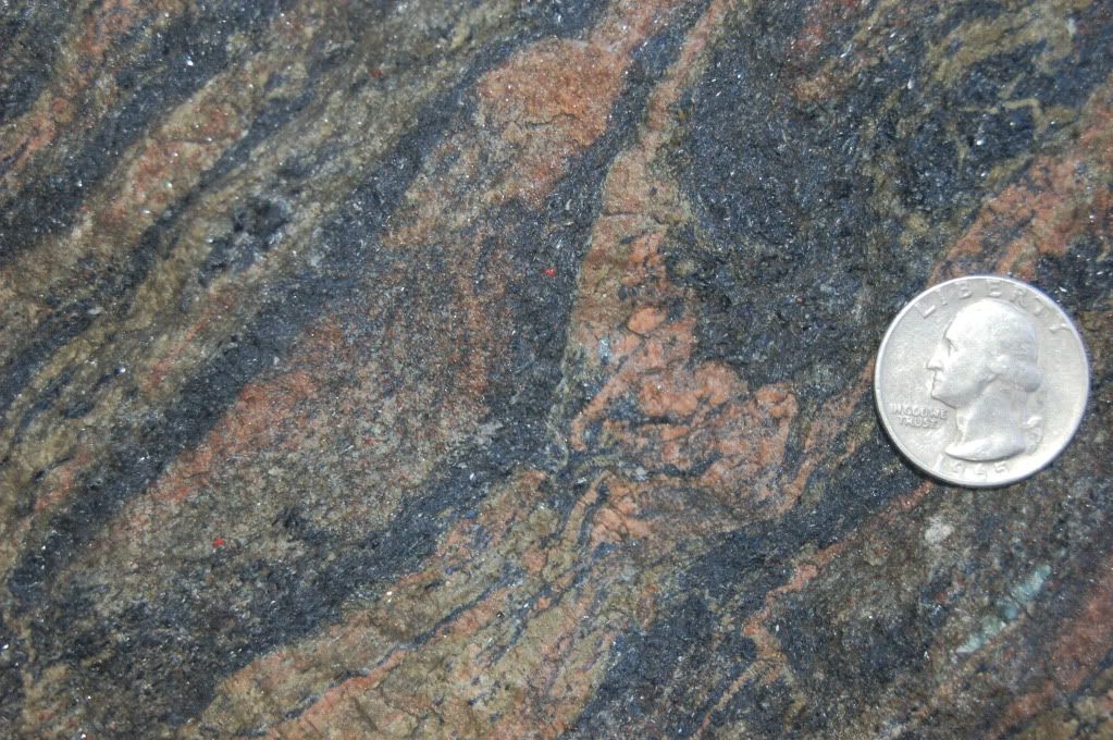
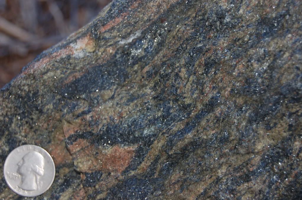
Today's fragment is one of my all time favorites, blueschist. This rock type is pretty easily recognizable, strangely enough, by it's blue color and schisty texture. The main mineral responsible for the blue color is glaucophane. Glaucophane forms at very high pressures, an equivalent of a minimum of 15-18 km (about 10 miles or more), yet relatively low temperatures of 200 to 500 Celsius. At those depths, the temperature should be much higher. So what kind of environment could have created this beastie?

It turns out this is a rock we couldn't have explained before the advent of plate tectonics. When cold oceanic crust subducts below the edge of a neighboring plate, there is some lag time before it can heat up to the ambient temperature of the depths it now occupies. Furthermore, since subduction consists basically of wedging surface material down into the earth, material along the upper surface of the subducting plate can be carried to great depths, detach, and be wedged back up toward the surface. In other words, material can be carried down to substantial depths (and the associated pressures), then fairly rapidly- in geologic terms- get shoved back toward the earth's surface, before it has time to heat up.

Of course, that's a pretty uncommon set of events. In consequence, blueschist is a pretty uncommon rock.

The first two pictures are looking parallel to the foliation. You can think of it as looking at a book edge-on; it's the view that shows the structure best.
Click for bigger.
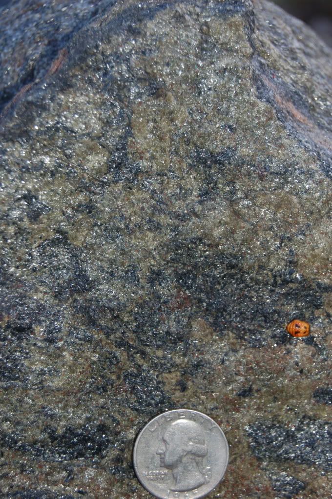
Click for bigger. And the third is looking perpendicular to the foliation- again, you can think of this as looking at the cover, or open page, of a book. You can't see the internal structure and contortions this material went through during metamorphosis as clearly, but (if you look at the full size picture) you can see the felty texture formed when a foliated metamorphic rock is dominated by acicular (needle-like) mineral grains. The term for this texture that I vaguely remembered was nematoblastic, but like so much I have learned, this term is now obsolete. Another rock type that I associate with this felty texture is amphibolite, a product of fairly high-grade metamorphism of basalt. (Followup: this surface is dominated by what is probably a mixture of chlorite and muscovite- not acicular minerals- but the felty texture that dominates the rock shows through pretty well, I think)
This rock is a boulder that sits at the southeast corner of Wilkinson Hall, the geosciences building here at OSU. I'm not certain of its source, but I'd be willing to bet it's from Bandon, Oregon.
(full-sized GE image)
There is a large pod of blueschist along the terrace just inland from southern shore of the Coquille River, and this rock was quarried to build the south jetty. If you're ever driving through, it's about a mile off Route 101, and very much worth the time it takes, to go look at the jetty. The quarry is somewhat overgrown, but collecting should be done in that area, not on the jetty itself.

One last thing: those of you who have had the oppportunity and pleasure of studying thin sections know how stunningly beautiful even mundane rocks can become under a petrographic microscope. Those who haven't, well, take a look at some of these pictures. There are quite a number of pleochroic minerals, those that change color depending on the angle and polarization of light passing through them, but there are very few as stunning as glaucophane. I think these photos are copyright, so I'm just posting the link. If gemstones looked as nice macroscopically as many minerals do microscopically, no one would have ever heard of diamonds.

Friday, June 5, 2009

Friday Fragment: For BrianR

I've been terribly remiss on my rock-blogging, and I apologize. These photos have been on my drive for nearly 3 months now; time to post them.

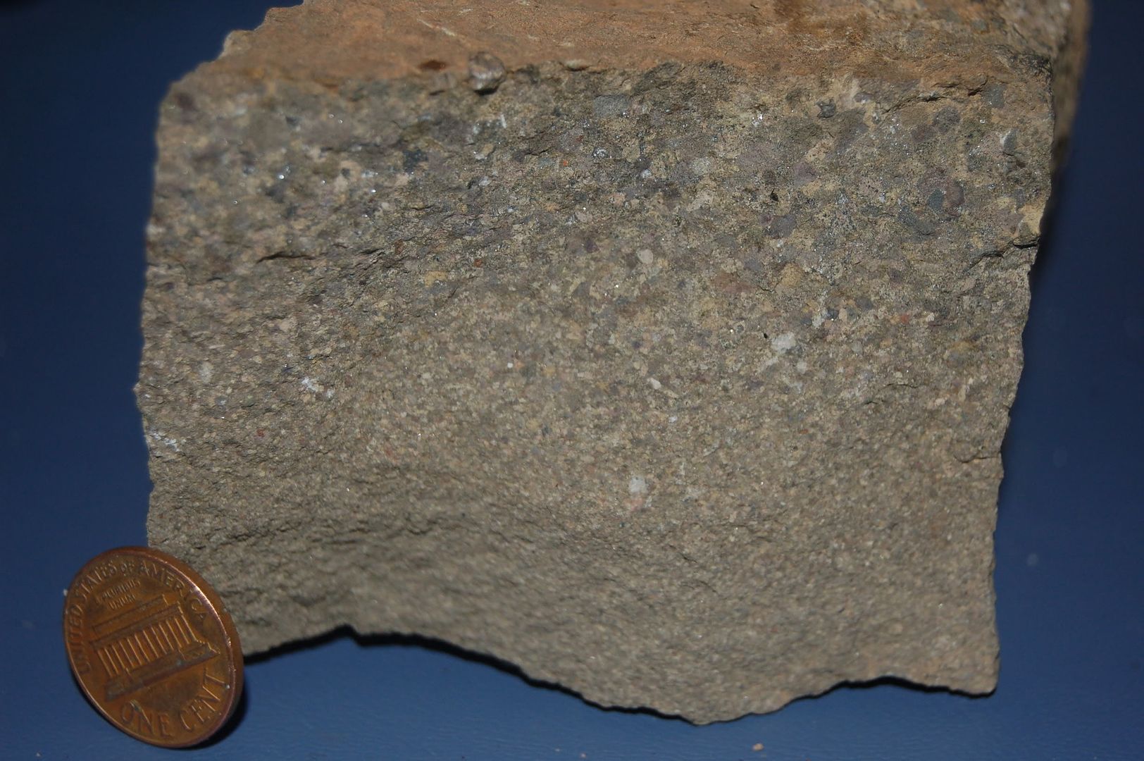
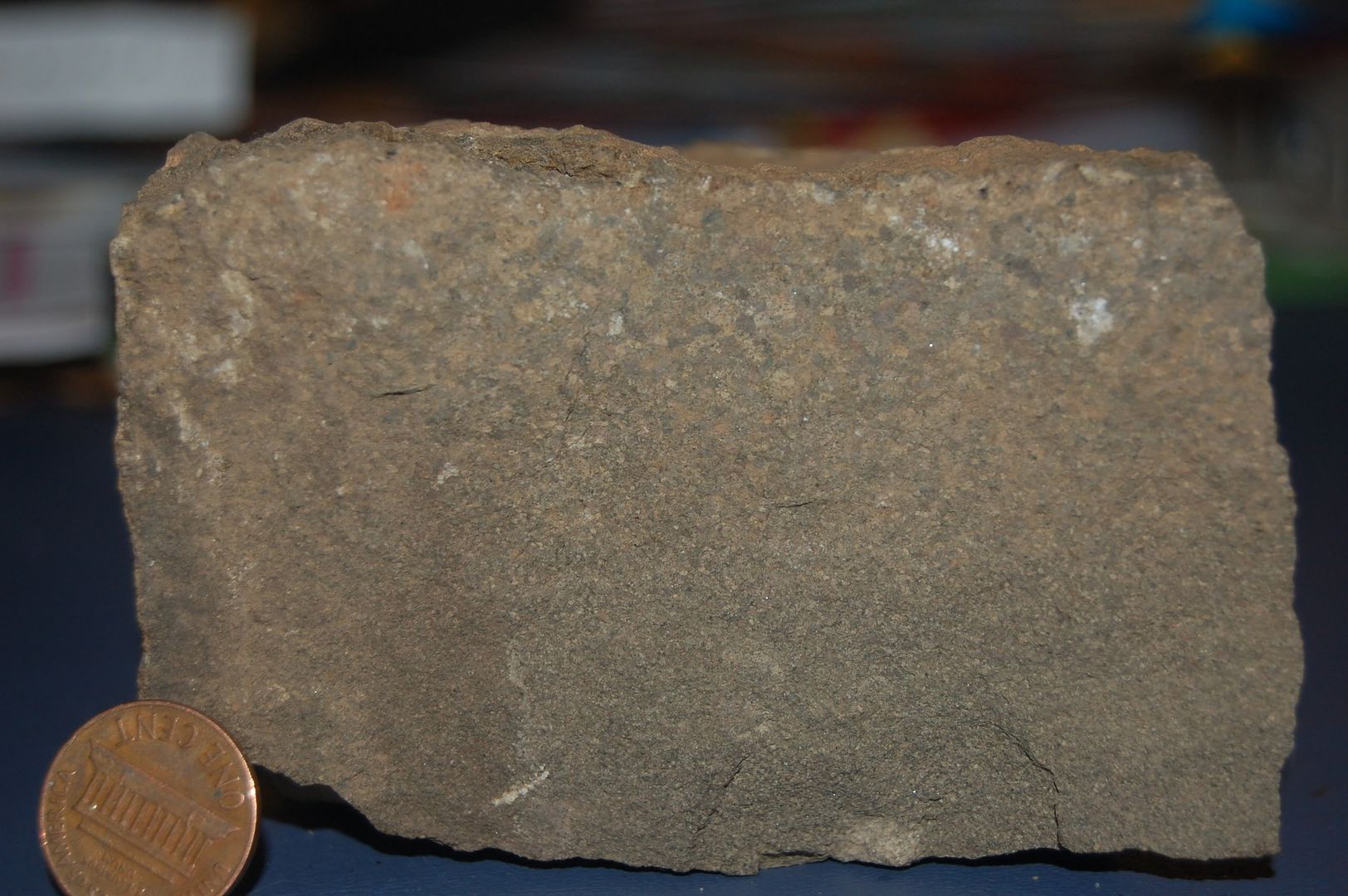
The rock is a sample of the King's Valley Siltstone (Tkv), a volcaniclastic sedimentary member of the Siletz River Volcanics (Tsr). The latter forms the "basement" of Siletzia, as described in the 3rd to last paragraph of this post. (The lowest and generally oldest rock in a regional sequence, "the basement" also sort of implies that it extends down into the earth far enough that for practical purposes, it doesn't really matter what's below it).

Tsr is mid to late Eocene in age, and I'll post on it some other time. It's thought to be, at its base, ocean ridge basalt. On top of that was formed a ridge of hot-spot, Hawaiian-style volcanoes. The importance of Tkv is that it shows these volcanoes emerged from the ocean and formed what must have been fairly substantial islands off the coast. (At the time, the coast would have been somewhere near the current axis of the Cascade volcanic arc, and these islands a little outboard of the current coastline) Had Tsr not emerged from the ocean, there couldn't have been enough erosion to produce these turbidites.

Tkv is intimately related to Tsr in a number of ways. First, near the contact, Tsr flows and pillows are interfingered with strata of Tkv. Second, as mentioned, the main source material of Tkv is weathered and eroded Tsr basalt. (At the site I collected this, there are also some interbeds of ashey rhyolitic tuff, which may be derived from the Challis volcanics of central Washington- but I can't vouch for that) As a result of the second point, the compositions of these two units are quite similar, and in weathered outcrops or drive-by geology, they can be difficult to distinguish.

The Kings Valley Siltstone member is fairly limited in areal extent, showing up in a band paralleling the Corvallis fault, another local feature I haven't discussed yet. It's also limited in terms of outcrops; I've only found a few, to the west on Marys Peak and to the north in Dunn State Forest (a unit of OSU's research forest land). Some of these outcrops, though, can knock your socks off. My favorite is a gravel quarry in Dunn SF, where one can clearly see the above mentioned interfingering, and I once found a most excellent feeding structure with radiating green phosphorite(?) worm poop. Carried the slab (~ 16x10x4 inches) home on my back too, about 10 miles. A friend of mine also found a magnificent turtle fossil in an outcrop near the town of Kings Valley- I tried to convince her that it might be an important fossil, and that she should show it to a researcher, but I couldn't get her to. It was about the size of a box turtle shell, but one corner had broken off, and you could see bone in the matrix. More mundane fossils (mostly mollusks, in my experience) can be found occasionally, but I've never seen a concentration of fossils anywhere.

From what I can remember, Tkv is a maximum of about 500 feet thick; that fits with my own trompings about. The top of the unit is pretty chaotic and unsorted, as is the bottom. The middle seems to be dominantly turbidites. Glassy basalt (sideromelane) and palagonite are abundant in the bottom of the unit, but absent from much less abundant in the middle, and then more near the top, though not as well preserved as at the bottom. I interpret these features to indicate less transport near the top and bottom, and from a more weathered source at the top.

So despite the lack of much research on this unit, I personally suspect it has a lot to offer, including a sedimentary record of the emergence, then erosion and submergence of a Hawaiian Island analogue, an admittedly spotty record of late Eocene life, but unique with respect to its location and time. It's also a beautiful area with overall good access- forestry (and the roads that go with it) rules a few miles to the west of my current position.

The pictures show three faces of the piece I have in my possesion at the moment, and show the graded bedding constituting the base of a single turbidity flow; the overlying finer sediments weather and crumble so fast they're very dificult to collect. And geo people should be able to see immediately that they're upside-down from the original deposition orientation- the "top" made a flatter, more stable position for photographing. Non-geo people should note that as you start from the top, the grains are larger, and as you move down, they get smaller. Turbidity currents (another thing I need to discuss in more detail at another time) start suddenly, then gradually slow over a period of hours to (maybe) a day or so. So the larger grains will drop out and settle first, then progressively smaller and smaller grains. The first deposited material is at the bottom of a sequence, later materials will be above, on top of, earlier materials, so the largest grains are at the bottom. Which happens to be on top in this picture, because the rock is "upside down."

Now here's the treat: I've learned how to upload big pictures, so the link below each will take you into a fantasy land of explicit geological detail.

BTW, this post is dedicated to BrianR, because he's always going on about turbidites, and I think he'll get a kick out of these.
I wanna see!
Big as a House! (just realized the first two are actually the same face from slightly different angles. Oh, well)
Penny the size of a grapefruit! (This is a slightly weathered face, but still fresh enough to see the texture)

I also wanted to mention that the glittery bits you can see are mostly the zeolite cement and some patches of calcite. Location information for this sample can be gleaned from the GoogleEarth screen caps below, or leave a comment for further info.
(Outcrop is immediately west of where the power line (~straight n/s swath) crosses the lower road (winding, ~e/w swath at the bottom).

Friday, March 6, 2009

Friday Fragment: Fossil Fishies!

Ok, ok, I know I'm a sucker for alliteration (for the worst- or best, depending on your perspective- example pertaining to geology, see this post from December). This was a gift many years ago, so I have no first-hand knowledge of where it came from. However, it's a safe bet it came from the Green River Basin, which is known world-wide as a tremendous source of excellently preserved fish and other fossils. The thing that's kind of special about this particular piece is that there is a single nice fossil on each side. In the above picture, there is a third head above the head of the complete fossil. I just went looking for some links to stick in here, and a photo of a Green River fish is the first one listed at the wikipedia page for Lagerstätte. If you want more, a Google search for "Green River Fossils" produces nearly 400,000 hits; some of the commercial dealers on the first page have some very nice material, for which they are asking some very nice prices. There are also some archives if you just want to look at pictures. Above is a crop from the second picture, showing the incredible detail preserved in these fossils.
The other thing about the Green River Formation that you should know is that it holds an enormous amount of fossil fuel in the form of oil shale. Quoting the oil shale article at wikipedia,
A 2005 estimate set the total world resources of oil shale at 411 gigatons — enough to yield 2.8 to 3.3 trillion barrels (520 km3) of shale oil. This exceeds the world's proven conventional oil reserves, estimated at 1.317 trillion barrels (209.4×10^9 m3), as of 1 January 2007. The largest deposits in the world occur in the United States in the Green River basin, which covers portions of Colorado, Utah, and Wyoming; about 70% of this resource lies on federally-owned or -managed land. Deposits in the United States constitute 62% of world resources (...)
In other words, the amount of oil in oil shales is at least double that known as petroleum reserves, and of that amount, the US has a bit less than 2/3 of the total. When "peak oil" deniers start talking about how there's enough oil to last for a century or more, this is what they're referring to- though they don't seem to actually know that, based on conversations I've had. I'm not necessarily against extraction of oil shale, but it's not as simple as all that. It is much more energy intensive to extract than crude, and creates much more negative enviromental impact. So even if you don't account for the enviromental costs, simply extracting it and converting it to a form useable by current technology means it will be much more expensive than traditional crude. It was looking like a hot area last summer when gasoline was at $4.oo a gallon; now... not so much.

Though I haven't actually read anything on this topic, I suspect that the low-oxygen, high-organic-carbon environment that led to the development of the kerogen-rich "oil" shales (technically, it isn't oil, and technically, the rock is more silty than shaly) is the same set of factors that allowed for such marvelous, highly-detailed preservation of fish and other organisms. And it is quite possible that in the future, a distillate from rocks like this one will be making your car run.

The Green River basin also has a hypothsized connection to my home turf, which I describe in the third from last paragraph in this post. Sorry I don't have a reference for you geology types out there; it was the cover article from a GSA Bulletin in the late 80's/early 90's.

Friday, February 20, 2009

Faulty Friday Fragment

Not too much to say about this fragment. It's a limey sandstone/siltstone with several little faults running through it. I picked it up on last spring's trip to the California desert- I think near Darwin (east side of Owens Lake), but I'm not really sure. The offset on the pair visible here look like reverse faults.
However, if you look carefully, the width of the fault is similar to the total offset.Now technically, a joint is a fracture that involves little or no offset parallel to the fracture surface. Place your palms together, then pull them apart a half an inch or so: that represents a joint. Put them back together, and slide one hand some direction without separating the surfaces: that represents a fault. In this sample, the separations both parallel and perpendicular to the fracture surface look to be about the same, so what should I call it?Looking at the side of the fragment (this is the side that was closest to the quarter in the first picture), you can see there's actually a larger fault running through the middle of the rock. My suspicion is that the two cute little microfaults visible in the first picture are more acurately described as brecciation (breaking, shattering, crushing) associated with this larger fracture. Brecciation that, in this case, appears to have a reverse offset. I'll still call them faults, because I'm rather fond of tiny little samples that capture what are normally very large features, but in this case, I'm quite unsure just how accurate I am in applying that name to these features.

This leads me to an important theme in geology: names and terms can be very useful in communication, but they can also get in the way of understanding if naming something becomes an inaccurate stand-in for actually describing it. What I want to do is understand how the rock formed, how it came to have the features it does. Noticing the features is necessary to do that, but naming them isn't necessarily necessary.

And regarding all the equivocation above, all I can do is apologize and repeat an old joke: "The world needs more one-armed geologists, so we don't have to hear, 'on the other hand,' every few sentences."

Friday, February 6, 2009

Friday Fragment: Welded Tuff

Today's fragment is a rock from eastern Oregon: a very nice welded tuff. I've just spent a little time trying to "disambiguate" tuff from ignimbrite; I've always sort of assumed that the ignimbrite was the event, the process so to speak, and tuff was the deposit, the product. According to wikipedia at least, both are deposits. And I'm left not too clear on exactly what distinguishes the two words. (Late addition: actually, I think tuff implies that the deposit is lithified; the deposit is an ignimbrite, whether it's lithified or not) But the general outlines, without worrying too much about terminology, are pretty easy. A large, explosive volcanic eruption ejects a sizable amount of pyroclastics (pyro=fire, clast=broken) which then travel across the countryside- I've described it to kids as a very powerful volcanic sandstorm. When this fragmentary material settles out to the ground different processes may cause it to solidfy as a rock. Whatever the process, the result is known as a tuff.

With a welded tuff, the fragmentary material is still hot and "sticky" or plastic enough to cement together as it settles. So this is not just a "volcanic sandstorm," it's a molten volcanic sandstorm. Imagine a "sandstorm" strong enough to carry rocks the size of a golf ball, and hot enough to still be a little molten (probably in the range of 700 degrees C, or about 1300 F) Now imagine this "storm" covering hundreds to thousands of square miles. It would be a very bad day. As I used to say when I was doing some volunteer teaching, it would be a fascinating event to witness. From low orbit.The major components of this rock are glass, sanidine, lithic fragments and more glass. I've looked at it in thin section, but I don't remember anything really being identifiable other than sanidine (a high-temperature form of potassium feldspar) and very dirty glass. The lithic (rock) fragments are presumably fragments of the country rock that were ripped out by the explosion and transported along with the ash flow. They're a mixed bag, though clearly of volcanic origin themselves. The thing that's really cool about this particular flow is the abundance of fiamme.
I think in all my previous rock and mineral posts, the full pictures have been reduced to 15% of original along both horizontal and vertical, and the "crops" have been bits of the full-sized picture, without reduction. The above is a crop, but reduced by 50%. I also have now figured out how to set the picture size in the the html, rather than settling for Blogger's default. This should be reflected with better resolution in my pictures. (As an aside, any geoblogger who'd like a full-sized copy of any of these pictures is welcome to contact me. I'd be happy to email the .jpg files; they're generally around 1.5 Mb) At any rate the above picture shows a nice pair of fiamme. As I mentioned in last week's Friday Fragment pumice can be thought of as the volcanic equivalent of popcorn; an enormous portion of the rock is pore space. If a pumice fragment is buried under a significant burden, and it's still hot enough to deform, it's easy to picture the pumice simply being mashed flat. The gas is pressed out of it, the walls collapse, and the glass bubbles weld together to form a more or less solid mass of glass. This isn't the only way fiamme form, but it's the common mode in welded tuffs.The above crop (full size) shows a couple of interesting features. First, you can begin to get an idea of just how abundant the sanidine is in this rock, though you can see that pretty well in the previous picture too. This picture also shows a couple of the lithic fragments along the middle of the right side. The large one is quite angular (as you would expect from an explosion fragment), and with the long axis about 60 degrees off from the bedding plane (which is basically horizontal). A fiamme would be concordant with bedding plane.I picked up this sample in spring of '84, and have never had an opportunity to get back to the spot, or more accurately to look for it and stop. I'm sure I would spot it on a daytime drive-by; I've got a clear mental image of the outcrop. But I don't know exactly where the spot is, other than it's not too far E-SE from Burns on route 78. In the above GE map, Burns is the town on the left (west) side; the road coming in from the SW and passing out to the NE is US 20. The road leaving Burns directly eastward then turning SE is 78.

This whole quadrant of Oregon is lousy with welded tuffs. When people think of Oregon volcanoes, most think of Hood, Mazama (Crater Lake), basically the big composite cones of the Cascades. People with a little more background will certainly know about the Columbia River Basalts. But it takes a while trotting around the state before you realize how ubiquitous, and varied- in composition, age and form- Oregon's volcanoes are. I think I would be quite accurate in saying that the only state more uniformly volcanic in nature is Hawaii.

Friday, January 30, 2009

Friday Fragment: Pumice and Tufa

Today's fragment is a piece of pumice covered with a crust of tufa, from near Mono Lake, California. Pumice is a light, frothy, rock created when silica-rich lava (rhyolite or similar) erupts from a volcano. Molten rock often has dissolved gas contents- mostly water- in the range of 1 to 3 percent, which doesn't sound like much. The mass of a cubic meter of silica rich rock is going to be around 2500 kilograms, so the mass of dissolved gasses in that will be around 25 to 75 kg (55 to 165 lb) or (roughly) 7 to 20 gallons of water. Water expands by (again, roughly) a factor of 1000 as it moves into a gaseous state, so picture two- five gallon water jugs suddenly expanding into 2000 five gallon water jugs... while buried within a cubic yard of molten rock. Suddenly 1-3% dissolved gasses sounds more substantial.

Essentially, pumice is volcanic rock that has "popped" like popcorn. It's known to countless numbers of kids as the rock that floats. Tufa can be thought of as non-marine, chemically-precipitated limestone. It's sometimes described as fresh-water limestone, but the bodies of water that it precipitates from are often salty. The above photo shows both the pumice and the odd texture of the white encrusting tufa. Below you can get a better sense of the size of the tufa crust.In the above picture, my finger is resting on the tufa crust, my thumb on the pumice. Below is the rock face my finger is on. If I was to find this with no broken surfaces, that is, with the whole rock coated in several millimeters of tufa, how would I know there was pumice inside? The simple answer is density, or perhaps more accurately, heft. I can't measure density directly by picking up a rock; I need a volume and a mass. But I do have a sense of how heavy a "normal" rock ought to be. In other words, I have a sense of how big (volume) a rock is as I reach out toward it, and my mind automatically makes an assumption regarding how much effort I'll have to put into picking the rock up (weight). If there is a mismatch between my assumption and my actual experience when I pick it up, I know to look for something "unusual."

Non-geologists tend to focus on color above all else, and can be convinced that other features are worth looking at with a little effort. But the range of observations, many almost unconcious, that one learns to make while looking at tens of thousands of rock, are more varied than any texts can ever explain. Below are a pair of crops from the first and second photos. Another interesting question this rock raises is "Is this igneous or sedimentary?" I love answering "either/or" questions with "Yes," and I will do so here. The pumice component is clearly igneous, the tufa component clearly sedimentary, so the rock as a whole is best described as having aspects of both. There are innumerable examples of rocks like this, that have two or more of the "rock-type trinity," igneous, sedimentry and metamorphic. Rather than fussing over whether a rock is one or the other, a geologist will spend more time fussing over the processes that created particular aspects or components of the rock. This is a picture my brother took with his cell phone when we were there last spring.
And the GoogleEarth view. I think I may have moved the pin since I copied the lat-long numbers (37.978308° -119.129022°), but not enough to make any difference. The major road running along the western edge of the lake is US 395, which has my vote for the most spectacular interstate route in the US.

Friday, January 23, 2009

Friday Fragment: Cobalt, Ontario Silver

I found this sample at a mine dump at Cobalt, Ontario. The two major minerals are quartz and cobaltite (mineral data, very nice crystal)
The Cobalt deposit is the result of volatile escape from late-stage aplites in the Nipissing Diabase. These aplites intruded the overlying Gowganda Formation, which is itself a fascinating unit of diamictites and other glacial sediments. The Gowganda has been regionally metamorphosed, but only at low T and P; surprisingly subtle sedimentary features are still preserved. So the mineralization is intimately associated with the diabase, but actually located in the sedimentary units.
The texture of this rock strikes me as probably representing a thoroughly replaced breccia, but the patchy nature of the quartz and cobaltite distribution may simply be the original texture, not a texture of the protolith.
Now the thing that excited me about this speciman can be seen in the second and third pictures (crops above and below respectively). Those little black streamers are native silver.
There is a wonderful loop you can do in Ontario if you ever have the opportunity; Sudbury is the world's largest nickle deposit, a sizable copper deposit, and an enormous meteorite impact. Go north to Timmins and tour a gold mine in one of the richest gold deposits of North America. Travel southeast to Cobalt; the area is largely worked out in terms of silver, but my sense is that there is still quite a bit of cobalt, and the mine dumps are a kick in the pants. From there travel south, with a stop near Temagami. On the road's crest on the hill just north of town, there's a great outcrop of banded iron formation and pyrite-bearing black slates. Then head to Bancroft, Ontario to check out some of the most exotic and extreme minerals on the planet.

I had the opportunity to do just this loop with a friend and fellow geology student in 1988; it was truly a wonderful experience.

Friday, January 16, 2009

Friday Fragment: Graphic Granite

I am very fond of the term "graphic granite;" it seems to carry the resonance of "graphic violence," or "graphic sex." So is graphic granite extreme or uncensored? Yes and no, sort of. Granite is the endpoint of segregation of the lowest melting temperature components of igneous rocks, so it's kind of extreme to begin with (actually, aplites could be considered even more of an endpoint here, but anyway...). Could it get more extreme? Yes. Pegmatites are the result of very slow crystallization, and thus have very large crystals. Now granite is slow cooling to begin with, and has by definition, large (visible to the naked eye) crystals. Granite pegmatites are not terribly uncommon, and they can have enormous crystals.

The two main minerals here are quartz and orthoclase feldspar. Biotite occurs as an accesory in this sample (we defined accesory minerals as those making up less than 2% of the rock). A blade of biotite can be seen near the middle of the above photo. Quartz is the darker grayish glassy mineral, while orthoclase is the creamy gray mineral that makes up most of the rock. (I think I remember ID'ing sphene or some such from this outcrop at some point, but I didn't see any in my scan over this sample)The reddish stains are probably from weathering of the biotite. So graphic granite is a pegmatitic granite with a very distinctive texture. The quartz and orthoclase crystallize out in a series of (more or less) parallel lathes. Looking perpendicular to the axis of the lathes, there is a peculiar columnar texture: And a close-up (a crop from the above smallified image):
Looking down the axis of the lathes, on the other hand, the quartz looks like small cuniform marks on the rock- hence, like writing: graphic.
1610, "traced" (implied in graphical), from L. graphicus "picturesque," from Gk. graphikos "of or for writing, belonging to drawing, picturesque," from graphe "writing, drawing," from graphein "write," originally "to scratch" on clay tablets with a stylus. (From here)

As an aside, "graphite" is also from the same root. In the above picture you can see the graphic texture- note fingers for scale. The texture is even more clear in the picture below.
In the below crop from the full-size picture, you can see the cuniform-like patterns that the quartz crystals form. You can also see clearly that the orthoclase is the major component of this rock. I will try again when we get some sunshine; I couldn't really capture it with the flash. If you look back at the close-up picture of the quartz-orthoclase lathes, you can see that one of the quartz lathes branches from the lower right to the upper left. So in the upper left, even though the two areas of quartz are separated, crystallographically they are continuous! That is, it's all the same mineral grain. You can really see this with the orthoclase: as you tilt it back and forth, all of the cleavage surfaces of that mineral glint at the same time.

About 90% of this rock is made of two enormous, intertwined and intergrown mineral grains!

So, yes, this is a pretty extreme rock... a "graphic" granite indeed.

This was collected just south of Denio Junction, Nevada. An oblique view to the southeast in Google Earth shows the hillside; the road is route 140. This is about 4.7 miles south of the junction. (note the yellow pin marking the general area. Pin location in GE is 41.875615° -118.597880°. Actually the outcrop is fairly extensive, and this is unnecessarily precise.)And in map view, Denio Junction is at the 3-way intersection to the west of the irrigation circles.
Very nice pair of photos here, including one of a graphic granite polished as a cabochon. This site also reminded me of the term perthitic, which I was trying to recall last night, but the texture didn't show up well enough in the photos to mention. Wonkish piece on experiments regarding the crystallization of this rock here.

So there's my first "Friday Fragment," which I hope is a fairly regular feature highlighting bits and pieces of our wonderful planet's corpus.