Showing posts with label Picture Me Stunned. Show all posts

Friday, April 24, 2015

Geo 1095: April 23, Day 843: Ollalie Creek

This is an isolated photo in this day's folder, and at first I wasn't certain what it's a photo of. But in terms of sequence, and comparing it to Dana's photos at the same location, it has to be Ollalie Creek. The Ollalie Campground is just off Route 126, where we pulled off to have a look at this entirely spring-sourced tributary to the McKenzie. The thing that threw me off is that I had forgotten what a large and voluminous stream it was. I remembered it looked awfully energetic, and that I wouldn't want to wade it- that it looked as if, without precautions, it could be quite dangerous. And like (nearly) all the other water in this area, it's only a bit above freezing, which makes it even more treacherous. But when I looked at this shot earlier, my first reaction was "Is that just a narrow spot on the McKenzie I've forgotten about?" Nope. It's a tributary stream.

Photo unmodified. July 7, 2013. FlashEarth Location.
Saturday, April 11, 2015

Geo 1095: April 11, Day 831: The Spring Who Shall Not Be Named

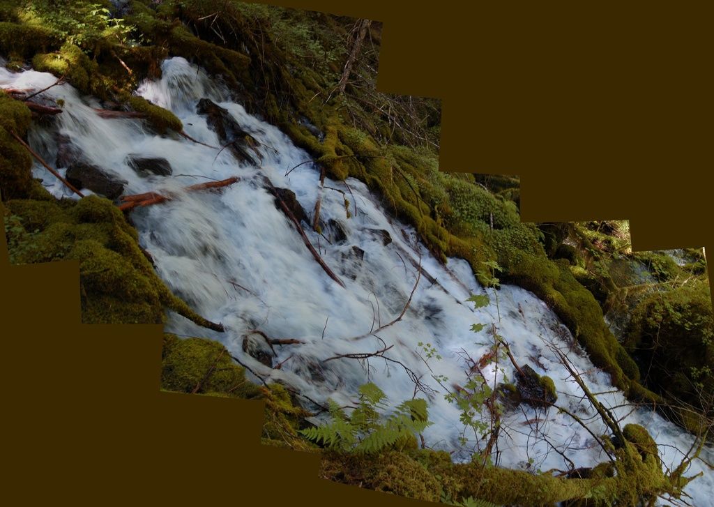
This set of shots was an experiment to see if HugIn could cope with a panorama that wasn't composed of more-or-less horizontally or vertically aligned photos. I'm neither entirely pleased nor displeased with it. It works well enough to be interesting. Anne took us to this spot after a solemn vow we wouldn't disclose its location, nor say anything of substance to identify it. There are sound environmental reasons for that, which I won't discuss further, and it's purposely not following my general practice of chronological order. However, it does relate to the hydrology of Clear Lake, so it's relevant following that site.

This spring, on it's own, has a flow that's twice (!) the flow through the Eugene Municipal water system. I don't recall the actual flow rate, but it's on the order of a few cubic meters per second. Now Eugene, the second largest city in Oregon, has an estimated population that's nearly 160,000 people. So this spring by itself releases enough water to supply the needs of a city of about a third of a million.

When lava blocked Clear Lake, about 3000 years ago, the rising water covered numerous springs that emerge in the area. They're still there, just hidden underwater. But I'm told there is an especially voluminous one near the northeast edge of the shore. I'd like to imagine that before it was drowned, this is roughly what it looked like. But maybe even bigger!

Photos stitched in HugIn, empty areas filled in Paint.Net. July 7, 2013. No location.

Wednesday, November 12, 2014

Philae: "Hey Folks, I Got You a Comet"

At some point, I'll copy over some tweets and retweets from the past couple of hours, but for the time being, science people on Twitter are being like this. And I'm one of them. I'm not sure that anything else will be happening today. Thanks, ESA!


Monday, May 9, 2011

Geology News in Photos

Today's In Focus feature is on the Japan earthquake, two months later. Above, a clock submerged by the tsunami records the waterline. I found these photos pretty shocking- the events at the time were plenty shocking enough, but the sheer quantity of debris to be cleaned up and disposed of is difficult to comprehend. A couple of others, #17 and #20, inspire my sometimes warped and generally tasteless sense of humor to caption them along the line of "Silly boats! U no belong there!"

Closer to home, The Big Picture has 30-some images of the flooding along the Mississippi River.There has been a slew of bad science journalism about this event, and the go-to site for accurate information and media corrections has been Steve Gough's Riparian Rap.

I spent my preschool years in Gallipolis, Ohio, and some of my earliest memories are of steamboats that still served as working tugs on that stream. I was in love with a boat named the Kathy R, and could recognize its distinctive whistle from miles away. In the spring of my fourth or fifth year, there was a flood that covered our yard- the ground floor of our house was several feet higher, and was not inundated. I vividly remember feeling like the house was afloat, no longer attached to the earth. I also vividly remember catching crawdads (as I grew up calling them), and being quite amazed that they were in the yard. I'm sure it's small consolation to the family above, but one, this flood will replenish your soil with nutrients and fresh sediment. And two, crawdads are exploring your farm. How cool is that?

Stay tuned as the geology world holds its breath in anticipation for upcoming excitement at Old River Control. I hadn't realized it until yesterday, but John McPhee's New Yorker article on that mega-project, which was later adapted as a third of his book The Control of Nature, is available online. If rivers or environmental engineering hold any interest for you at all- and they both should- this is definitely a recommended read.

Wednesday, April 27, 2011

Cascades Snowfall

(Photograph by Tyson Fisher, submitted to My Shot, from National Geographic)

It's been about five years since I last visited Crater Lake, and it looks like I may get the opportunity to do so again sometime this summer. It's kind of startling to see massive snowbanks persisting into July, but they do. The amounts of snow that fall in the Cascades are difficult to comprehend. Despite the high elevations, summer temperatures can get quite warm, but the sheer amount of snow means that it can take most of the summer to melt off.

We had a good amount of snow coming into the new year, then January and February were dominated by "warm" systems that either didn't add to the snowpack, or, in some cases, actively melted back what was already in place. As a result, at the beginning of March, our snowpack was about 70% of normal for that time. But March and April have been cold, with numerous winter-style storms, and the snowpack is now well above normal (I'm recalling about 120%) throughout the Oregon Cascades. That bodes well for the fire season, for irrigation, for salmon, for hydropower generation... water is important, even in a region that is often perceived to have a surfeit of it.

The news that brought this to mind was this article from The Salem Statesman Journal:
KLAMATH FALLS, Ore. (AP) — The total snowfall at Crater Lake National Park has pushed past 600 inches, with more expected before the end of the season.

The Herald and News reports that 9 inches of fresh snow measured Tuesday increased the total snowfall to 615 inches, well above the 492 inches normally measured by April 26.

Click over to read the rest- I think you'll find the numbers pretty hard to believe. Keep in mind that 615 inches is much greater than the total amount on the ground at a given time, just the total that has fallen over the course of the winter- the total on the ground at park HQ is 12 feet, not 51 feet. But still, picture enough snow to bury a five story building, and tell me if you don't find that kind of breath-taking.

Thursday, April 14, 2011

Geo-Mystery

Interzone friend Katie, who will soon be off to Connecticut for her PhD in psychology, sent me an interesting link yesterday to the Wikipedia article on The Devil's Kettle at Judge C. R. Magney State Park, Minnesota. Take a look at the picture and spot the problem:
The Brule River splits in two just above a waterfall and falls in two cascades. That's not all that unusual; in fact it's pretty common. What's odd here is that one of the streams falls into a pothole. But wait! Even though that made me do a double-take, reading the text really blew my socks off. See, no one knows where the water goes, and a number of obvious tests have been done to solve the problem without useful results:
One [theory] is that, after dropping down the pothole, the river runs along a fault underground, or as a variant, that it enters an underground channel and comes out somewhere under Lake Superior. Both of these ideas have one valid aspect in common: they recognize that water must move downhill! But the main problem is creating a channel or conduit large enough to conduct the impressive flow of half the Brule River! Faulting commonly has the effect of crushing and fracturing the rock along the fault plane. This could certainly increase the permeability of the rock - its capacity to transmit water - but the connected open spaces needed to drain half the river would be essentially impossible, especially for such a distance. Furthermore, there is no geologic evidence for such a fault at the Devil's Kettle. Large, continuous openings generally do not occur in rocks, except for caves in limestone terranes. The nearest limestone is probably in southeastern Minnesota, so that doesn't help... Maybe the Devil's Kettle bottoms out fortuitously in a great lava tube that conducts the water to the Lake... Unfortunately for this idea, they are not the right kind of volcanic rocks! Rhyolites, such as the great flow at this locality, never form lava tubes, which only develop in fluid basaltic lava. Even the basalts in this area may not be the "right kind", being flood basalts that spread laterally as a sheet from fissures, not down the slopes of a volcano. No lava tubes have been found in the hundreds of basalt flows exposed along the North Shore. Furthermore, the nearest basalt is so far below the river bed, and even if it did contain an empty lava tube (very unlikely after its long history of deep burial) the tube would have to be both oriented in the right direction (south) and blocked above this site so that it isn't already full of debris. And there are no reports of trees or other floating debris suddenly appearing at one spot offshore in Lake Superior. The mystery persists.
Wow. This is a delightfully puzzling planet.

Wednesday, February 2, 2011

Frostnarok

Yes, it looks like a promo poster for some post-apocalyptic disaster/action movie. But, no, it's not; it's Chicago this morning.
E. Jason Wambsgans, Chicago Tribune, February 2, 2011: Abandoned vehicles litter northbound Lake Shore Drive on Wednesday morning.
CJSD yesterday offered the top ten nicknames for this storm. The title of this post was lifted from number four.

Saturday, January 29, 2011

Extreme Hikes at Extreme Heights

I've posted an older video of El Camino (Caminito) Del Rey before, but this one, from last year, is almost twice as long, and every bit as gut wrenching:

By the way, I just realized that the "old" (i.e. "functional") embed code is still available at YouTube; I'll be going back and fixing Saturd80's in a bit.

The hiking trails at China's Mount HuaShan are in far better repair, but I have enough acrophobia that I still wouldn't be able to cope.

In both cases, I'd dearly love to visit these spots: the landscapes and rocks are beautiful. But I get queasy just looking at the clips. I know for a fact I'd be utterly paralyzed if I went there in person. On a positive note, according to the Wikipedia page (link above) for El Caminito Del Rey,
The regional government of Andalusia budgeted in 2006 for a restoration plan estimated at € 7 million.

The President of Malaga Provincial Government, Salvador Pendon, announced that the budget to restore the three-kilometre walkway is €8.3m, financed by the provincial government.

The project will take approximately three years from when it is due to start in mid-2011.
So apparently, in the not-too-distant future it will be possible for humans who aren't part mountain goat, part spider to enjoy this trail once again. I, on the other hand, will most likely stick to gentler landscapes.

Friday, January 21, 2011

Lotsa Water

I think Anne at Highly Allochthonous was the first to post this, along with some great discussion and explanatory hydrographs, but because RSS gives you the most recent articles first, I first saw it at KATU and OregonLive. The OL article has a more standard news perspective, if you're not into Anne's hydrogeological approach. KATU also has a story surveying tentative plans to restoring the wiped-out road, which no longer exists: the Sandy River is currently flowing where the road used to be. (Followup, 6:28- OregonLive also has a piece about reconstruction of the road, and an excellent aerial photo of the damage.)

Anne also mentions the February '96 floods, which I recall vividly. I was not out and about during those, though I did go downtown one afternoon to look at the water encroaching toward 2nd street, and it was not until mid-May when I found a field trip completely disrupted by washed out, debris-covered or severely damaged roads that I understood at a gut level how bad that set of floods had been. There are several areas in the Quartzville Creek drainage that I've been keeping a curious eye on for the last fifteen years, watching the recovery as plants have recolonized and various processes conspire to slowly hide the geological evidence of that mess.

As Anne correctly points out, last weekend's flood was not such a big deal- yes, it caused some local problems, and a number of people have lost possessions and homes, but no one was killed, and as far as I've seen no one was even hurt, though there may have been some discomfort when the power failed. As scary as the above footage is, in my mind, this was a good disaster: no casualties and awesome documentation. Another example of a good disaster was last year's volcanic eruption in Iceland. (No, I'm not going to look up, copy and paste its spelling.)

Other, much more seriously attention-deserving floods have occurred already in this young year, namely in Brazil and Australia. Today's Big Picture (The editor is moving on to another position, but says Boston.com's photo staff will continue the blog) showcases the Brazilian flooding and associated landslides/debris flows. And January 3rd, the same feature shared photos of the Australian floods. These two and other flood events (for example, "Sri Lanka, which suffered a 1-in-100 year flood this month.") are discussed in meteorological detail by Dr. Jeff Masters at his Wunderblog, who says
NOAA's Climate Prediction Center currently puts the La Niña event in the "strong" category, and whenever a La Niña or El Niño event reaches the strong category, major perturbations to global weather patterns occur. This typically results in record or near-record flooding in one or more regions of the globe.
Still, keep in mind some aren't sharing in this hydrologic wealth. An article that I would have read but probably not mentioned here, if not for the fortuitous context in which to place it, notes Prineville's water woes. Prineville is in the center part of Oregon, on the other side of the Cascades, and thus in their rain shadow. Trying to infer between the lines of this article, it sounds as if the problem is more about the groundwater geology and conserving scarce surface water resources rather than simply the dry climate, but the community is bumping up hard against the water limit, whatever the cause. "The reason the city is so interested in developing better wells is because, as it stands now, the city does not have the capacity to serve its existing residents, Klann said."

So yes, it has been a wet and mucky winter here in western Oregon, as was predicted when a La Nina developed in the second half of 2010. But overall, it could be a lot worse.

Followup: Heehee... just found this. Is it related enough? Sure, why not.
Funny Pictures - Spell Evian backwardz
see more Lolcats and funny pictures

Wednesday, January 19, 2011

Jaw Dropping

I am stunned to read that "There were 32 reported incidents at Portland International Airport last year in which the safety of planes was put at risk by people pointing at them with lasers." How do you explain that? I mean, I can see a few accidents, where someone inadvertently beams a plane, and the occasional crank/lunatic/sociopath, but seriously? Once every eleven days or so? There are dozens, even hundreds of passengers and crew on those things, and every one of them is put at risk. How, exactly, is it that there are people doing this, apparently for shits and giggles? And according to the article, PDX isn't even near the top of the list:
There 108 incidents at the Los Angeles airport last year, more than any other airport, FAA said. O'Hare was next, with 98, followed by airports in Phoenix and San Jose, Calif., both with 80; Las Vegas, 72; Philadelphia, 66; Oakland, Calif., 55; Honolulu, 47; San Francisco, 39; Denver and Newark, N.J., both 38; Tucson, Ariz., 37; Miami and Salt Lake City, both 36; Portland, Ore., and Ontario, Calif., both 32; Burbank, Calif., Orange County, Calif., and Baltimore, each 31, and Seattle, 26.
I swear, my species makes me sick sometimes. Next time you feel inclined to flash a laser at a plane, do us all a favor and go play with some nitroglycerin in a remote open field instead.

Thursday, October 7, 2010

Glacier in... New Mexico?

My friend Al sent me a link earlier with the title "Instant Glacier," which I just got around to reading.  Sort of funny, sort of amazing.  According to an article in New Mexico Geology, Volume 26, #4 (November 2004),
Hail accumulations reaching 12 inches were followed by as much as 5 inches of rain. So much rain fell in such a short period of time that the pea- and marble-sized hail was carried along first as sheet flood and then concentrated in a small drainage tributary to Sand Draw (Fig. 3) estimated to be approximately 15–20 ft deep. Approximately 8 mi south of Clayton just off NM–402 (sec. 10 T24N R35E), the hail began piling up behind a 12–16 ft culvert that was unable to handle the flow. Hail filled the small draw, as rain continued to flow across the fields, through the tons of ice, and onto the highway.
And the result? Instant glacier! Check the link for many more photos and the full story. (579 kb PDF)

Wednesday, October 6, 2010

A Gruesome Big Picture

I'm always a little surprised at the speed with which Boston.com's Big Picture delivers its timely photojournalism on recent events, though sometimes, as with today's edition, I find the results disturbing.  Toxic sludge at an alumina processing plant broke through a retention dam in Hungary on Monday, inundating a nearby village, and severely impacting a number of others.
The volume of sludge is estimated to be a 700,000 cubic meters.  From an article at The Guardian,
Hungary declared a state of emergency in three counties yesterday after a dam burst at an alumina plant in Ajka, releasing a torrent of toxic red sludge that swept through local villages. Four people were killed, three reported missing and 120 were injured.
And below is some video of the deluge, posted by The NYT, (more video of the cleanup at the link) looking for all the world like something out of a Bible story.
I haven't seen anything on the composition of this material, but apparently, it's quite alkaline- many of those hospitalized are suffering from chemical burns. I'd presume a large component is iron oxides- iron oxides and aluminum oxides make silica (SiO2) look highly soluble, but reports are saying there are lots of other toxic metals in this witch's brew. Gack.

Friday, September 17, 2010

Rowdy

Looking from the parking lot, away from my old high school, and down toward the football field, this mess is the result of one or more tornadoes that hit The Plains and Athens, Ohio last night. I have heard no word of injuries or fatalities resulting, but I'm sending best wishes to folks back there. Though I've lived in Oregon for most of my life, I'll always think of Athens as "home."

BTW, our class, AHS '77, was nicknamed "Rowdies," because, well, we were. Seemed like an appropriate post title. Here's a link to the full gallery where I found this; can't guarantee it'll stay put or public.

Followup: Here's another gallery, including the front page of today's Athens Messenger... a paper we used to refer to as "The Mess." Heh. And here's a funnel in development from YouTube.

Followup 2: Here's a local news article. I gather there were in fact a few injuries.

Tuesday, August 31, 2010

Trends

A couple of bloggers I follow posted some thing about "beating the game" yesterday. I don't make a habit of playing games, let alone beating them, and I didn't see any keywords that grabbed my attention, so I scrolled by after a brief pause.

That's important to understand: most of the items I "read" are glances at the headline and the first few lines or sentences to quickly decide whether I want to spend the time to read the whole thing. This is especially true for RSS feeds that provide only a title and a teaser: if you want me to read your stuff, and you expect me to click over to your website to do so-especially websites loaded with ads and sidebar add-ons- try to give me some idea what the fuck I'm going to see when I do. I've been getting really frustrated with this, and I've been dropping feeds that are the worst about it.

Despite this, or perhaps because of it, the number of RSS items I "read" (I think of it as "sort through") in a typical day has increased by about 25% over the last few months. Last spring I was averaging a bit over 1000 per day. Now...See why I tend to put off time-consuming posts for the weekends?

Then I found the relevant article in my "Google-related" folder, and given that I started using Google Reader well over a year ago, I guess I've beaten the game too:
Eagle-eyed viewers might have also noticed we've added a new category to the trends page: clicked trends - now you can see which sources you click on the most.
And finally, something many of you have asked for before...we now show you your lifetime read item count. That's right. Every. Single.* Item.**

*Only things you've scrolled by, or clicked on - doesn't count mark all as read.
**Okay, that's not quite accurate - once you hit around 300K (which we know some of you are already over) we stop counting for performance reasons. Consider that "beating the game".

Tuesday, August 17, 2010

Ground Zero

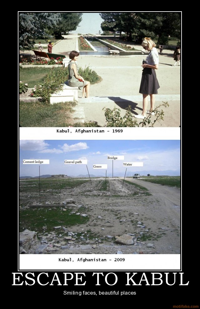
I had read that during the late sixties and early 70's Afghanistan was, if not a "first world" country, actually fairly modernized and prosperous. Then the Soviets invaded, and we funded and supplied arms for a counter-insurgency. We provided training in guerrilla tactics, and poured in weapons and ammunition. The Soviets gave up and left. The Taliban became the defacto government. Then educational descendants of those we trained attacked us, here at home. Then we invaded Afghanistan. It's easy to forget that the Afghani people have effectively lived under a state of continuous war for over thirty years now. And it's freaking mind boggling to actually see the changes wrought by those thirty years.What Would Jack Do? On a related note...
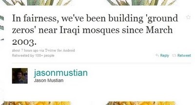
Darius Whiteplume's Tumblr

Saturday, August 14, 2010

Temperature Extremes

According to NWS/NOAA, we just reached 100 degrees a little while ago. I don't cope with 90+ happily, and the centennial mark feels like a stake in the heart to me. On the other hand, it's a dry heat. With a dew point of 47, the relative humidity is 17%, and there's a bit of a breeze. So it's more of a convection oven feeling rather than being pressure cooked. I'm thinking I may go home and take a nap and a cold bath at the same time. As I mentioned to someone a few minutes ago, it's days like this that make me appreciate February. Could be worse, I suppose, and Monday, it looks like it might be. But we're nowhere near our all time records. This chart from Bits and Pieces is pretty wild. If I had thought about it, I might have guessed our record range was in the neighborhood of 160 degrees, but both the record high and record low are more extreme than I would have assumed.

Friday, August 6, 2010

Smoke In The Valley (From Fires in The Steppes)

I've noticed the last couple of afternoons that it has been kind of hazy here in the valley. I didn't think much about it- it often is hazy on hot summer days. Some of it is from the oxidation of dimethyl sulfide, produced by plankton at the coast. It oxidizes to sulfate, which forms aerosols and cloud condensation nuclei: haze. Some of the haze is also due to volatile compounds produced by the dense and enormous west side conifer forests. A third source during the later part of the summer is local fires- wild, or set purposely for forest or agricultural management. (Ironically, our clearest days occur in the winter- which is notoriously cloudy. But when it's clear, it's very clear.)

So the haze is no surprise. The surprise is that this haze is being blamed on the historic heat wave, drought, and associated fires... in Russia!
Haze in the Willamette Valley likely traveled all the way to Oregon from Russia, rather than over the Cascade Range from a small wildfire near the town of Sisters.

National Weather Service meteorologists say smoke from more than 500 wildfires that have burned through forests and peat bogs in Russia is being carried across the Gulf of Alaska and down to the Northwest.
On Monday, The Big Picture ran a gallery of 38 photos from the Russian fires, which I found pretty mind-boggling. But for the smoke to be making itself known halfway around the world? Wow.

Monday, July 19, 2010

What Do You Do in Your Spare Time?

I spend a lot more time reading Wikipedia than I do watching television, but I've never registered, and thus never edited or contributed. Information is Beautiful: Cognitive Surplus Visualized.

Sunday, July 18, 2010

The Circum-Atlantic Trail; Circum-Planetary Trail?

The BBC has an interesting article about apparently active efforts to extend the Appalachian Trail into Canada, and around the entire North Atlantic Ocean.
The forces that threw up the Appalachian chain 350 million years ago also formed mountains across North Africa, back when there was no Atlantic Ocean, when the continents were all one - the Pangaea supercontinent - and they were linked together.

So why not link them up again, by extending the walking trail and persuade people with strong thighs and a very great deal of time on their hands to stroll all the way from Georgia to the Atlas Mountains, north of the Sahara?
OK, I see some logistical problems with this. As the article points out, there's the small matter of, well, an OCEAN in the way. But I can also see plenty of ways to deal with them. Overall, the idea of a trail to geologically reconnect two landmasses that began to separate in the late Triassic is profoundly appealing to me. I don't expect to be hale enough to ever walk a significant portion of it, nor even live to see it completed, but I find the vision compelling.

So compelling, in fact, that my imagination immediately leaped to the idea of another trail extending across the Gulf states, the Ouachitas and Colorado Plateau, to connect the south end of the Appalachian Trail with the southern end of the Pacific Crest Trail. Then extend the PCT north into Canada and Alaska... and you can see where I'm going with this.

Very few people would have the wherewithal and time to complete a circum-planetary trail, but many would have the opportunity to walk a portion of that. The opportunity to highlight and educate people about our globe's geology and history would be unparalleled. And the symbolism...

I moved to Corvallis from a suburb of Cleveland, Ohio named Mentor. The house that I had been living in there, my grandparents', was about a half a mile from Federal Route 20. When I moved here, I discovered that I was about a half a mile from Federal Route 20. It was as if I had just moved a bit down the road, though the climate, landscape, culture, biome and everything was thoroughly new to me.

Imagine standing in the Atlas Mountains in Morocco and seeing a sign pointing north, labeled "Maine, Georgia and California." And a sign pointing east labeled "Persia, Himalaya, and Mongolia." How would that make you feel?

I can't speak for you, but it would make me feel more connected to the entire world, not just my little parochial corner of it. I may be a curmudgeon and a cynic, but I can still dream.