Saturday, May 2, 2015

Geo 1095: May 2, Day 852: Joint Surveillance

Here we're looking basically perpendicularly into another pair of approximately parallel joint planes. The lens cap (52 mm diameter) is resting against the farther joint, and there a similar plane in the upper right quadrant. It should be clear, even in this shrunken format, that the rock is chock-a-block with a myriad of little holes. These are gas bubbles, referred to as vesicles, that were created as the original lava depressurized and cooled, just like bubbles forming in a carbonated drink after you pop the top on the can or bottle. The texture is called vesicular, and is quite common in volcanic rock. One might suppose that such a texture would also allow water to percolate into and through the rock, but the problem is that the bubbles (in most cases) aren't connected enough to permit flow except at very low rates- the distinction is described by "porosity" versus "permeability." Porosity refers to the amount of void space, while permeability refers to the degree that porosity permits flow-through. Vesicles increase porosity, but not permeability; joints increase both.

Photo unmodified. July 6, 2013. FlashEarth location.

Friday, May 1, 2015

Geo 1095: May 1, Day 851: Lichen the Joints

As I indicated yesterday, joints cutting through more or less solid, blocky rock are crucial to understanding how the enormous amounts of precipitation that falls in the High Cascades as rain and snow simply disappear over the many square miles that comprise this plateau. This is a surficial feature, and I'd guess the deeper buried joints don't tend to be as wide, but clearly, even at a fraction of this width, such fractures would allow rain and snow melt to easily trickle down to the water table. There's a bit of a mystery here, as it has become clear that the hydrologic divide in this area is not congruent with the topographic divide. In most environments, ridge crests mark the boundary from which water flows into one basin or another, but this is not the case here. Water is clearly flowing, hidden underground, across the Cascade crest, predominantly from west to east. I'll clarify and expand on that later.

Another interesting thing I notice in this photo is that lichens seem to be present in the shaded portions of the shot, but absent in the areas that are fully sunlit. On one hand, that may be just a fluke of this shot and the time of day I took it. On the other, it makes sense to me that the scorching heat of dry basalt in full sunlight would make it much more difficult for lichens and other colonizing organisms to become established. So areas that are shaded, at least sometimes, during the warm and dry season are easier for the lichens to live upon.

Photo unmodified. July 6, 2013. FlashEarth location.

Thursday, April 30, 2015

Geo 1095: April 30, Day 850: Aa

"Aa" (pronounced "ah-ah") lava is rubbly and often jagged on the surface. This "texture" forms as somewhat viscous, or pasty, lava flows cool and solidify on their surface, but are disrupted and broken as the still molten interior continues to flow, dragging the exterior along for the ride. This implies that the rubble we see at ground level should give way to more or less solid rock at some depth below. There are some magic asterisks after "solid rock," though. First, as the deeper lava cools and shrinks, it will develop fractures called joints to relieve the tension caused by decreasing volume. Second, lava flows like this often move like a bulldozer or tank tread: the upper surface moves forward and rolls over at the front of the flow, then stabilzes, fixed on the ground where it came to rest. That rollover process further breaks up the cool exterior and creates a bed of broken rock called a "basal breccia." Finally, in an active volcanic area like McKenzie Pass, there are flows on flows on flows, so if you were to dig a shaft or borehole here, you'd expect to see that sequence of {aa-> solid with joints-> basal breccia} repeat many times. I don't know that the aa and basal breccia would necessarily be easily distinguishable, though, so it would probably look more like {breccia->solid with joints} repeatedly.

This is key to understanding all the gushing water we saw in the upper McKenzie Valley...

Photo unmodified. July 6, 2013. FlashEarth location.

Wednesday, April 29, 2015

Geo 1095: April 29, Day 849: Anne & Chris Again

This is almost a repeat of yesterday's. I try to avoid that by poking around nearby shots before selecting the one I like best. Apparently I didn't do that yesterday, but I like this one better, and they haven't seen it. My blog, my rules. North (closer) and Middle Sisters in the distance.

Photo unmodified. July 6, 2013. FlashEarth location.

Tuesday, April 28, 2015

Geo 1095: April 28, Day 848:Anne, Chris, Dee Wright and (Two of) Three Sisters

After leaving the Deer Creek area, we headed up to McKenzie Pass to take in the views from Dee Wright Volcano Observatory. Here we see Anne and Chris on the upper platform, with North and Middle Sisters as a backdrop on the left. (See this post for all four of our merry band of geotrippers. If you can't tell, that's me on the left and Dana on the right.)

I've already posted a number of panoramas of the views from atop the observatory (See July 9, July 10, and July 12 of the Geo 365 series), so the coming posts will focus on some of the nearer features here.

Photo unmodified. July 6, 2013. FlashEarth location.

Geo 1095: April 27, Day 847: Deer Creek Bridge

Looking upstream from Deer Creek Hot Spring to the bridge, this shot gives some context for how to find the spring. There's some parking near the west (left, from this perspective) end of the bridge, and some intertwining footpaths from the road down to the riverside here. I suspect the line of cobbles in the lower left were purposely placed to divert the cold river water around the warm puddle of the hot spring.

Photo by Dana Hunter, unmodified. July 7, 2013. FlashEarth Location.

Sunday, April 26, 2015

Geo 1095: April 26, Day 846: Deer Creek Hot Spring

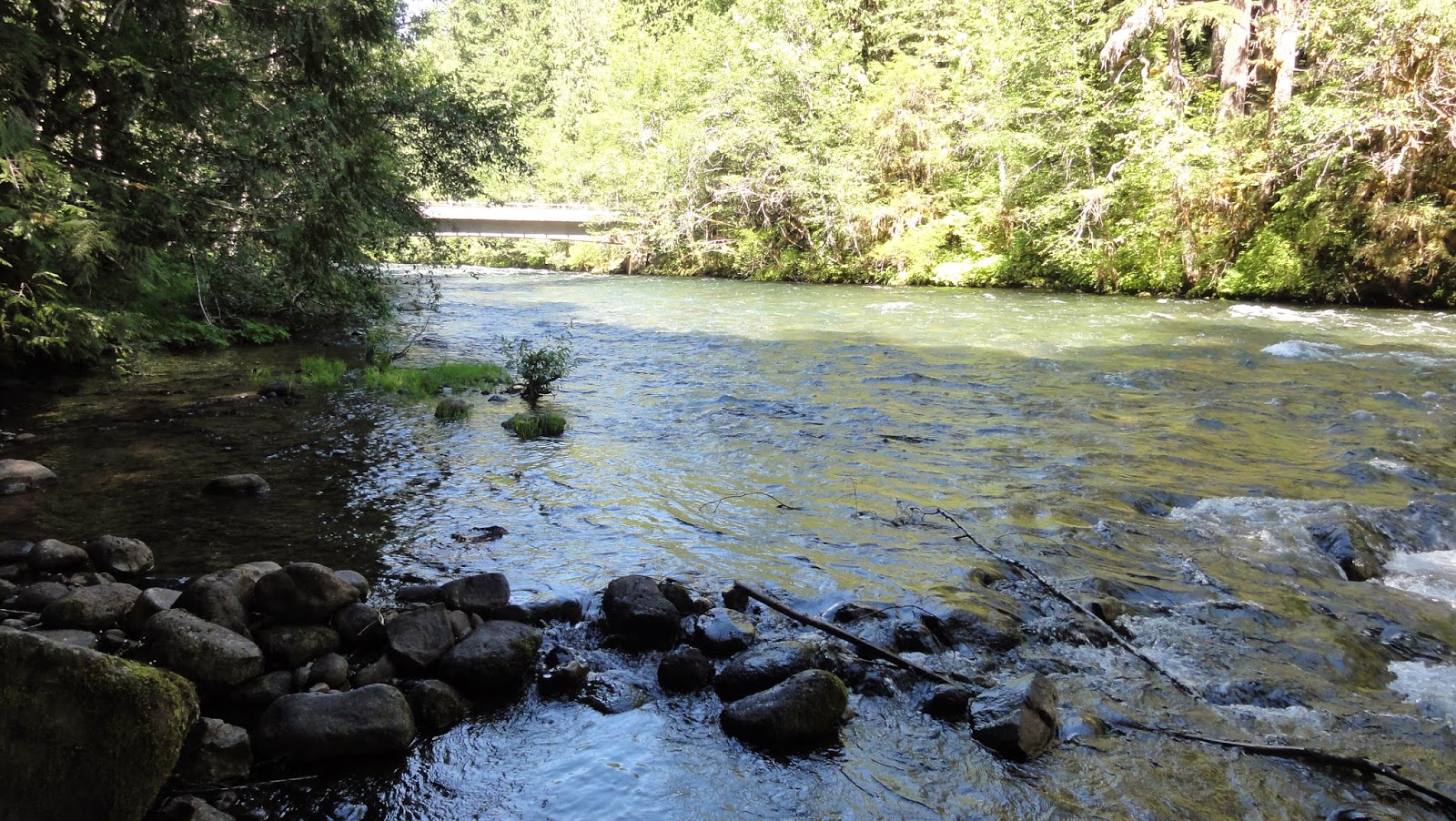
The other feature to visit from Deer Creek Bridge is a nearby hot spring, maybe a hundred yards downstream from that crossing. It's at the river's edge, and as far as I'm concerned, not terribly appealing in terms of bathing. It's shallow, kind of yucky looking, and smells strongly of sulfur. Now, again, IMO, this doesn't make it less interesting or worthy of inspection, just not a hot spring I'm inclined to get into, physically.

On the other hand, I know a number of people who have, and they enjoyed it. Whatever floats your boat. However, if you're the sort of person who's discomfited by having a bunch of geology types come gawking at the spring while you're soaking in it nude, you might want to think about some sort of bathing suit or rethinking your choice about where to stew. This is a well-known, easily accessible, and fully public location. Strangers may show up at any time... clothed or not.

While hot springs in and of themselves are uncommon enough to be intrinsically interesting, this one likely marks a permeable region along the western fault (system?) of the High Cascades Graben. There are a number of hot springs along this trench, some of which are developed, others, like this one, just warm puddles in the woods.

Photo by Dana Hunter, unmodified. July 7, 2013. FlashEarth Location.

Sunday Funnies: Gray Hair Edition

Tastefully Offensive
"Something wrong here..." Bad Newspaper
Tastefully Offensive
What Should We Call Grad School?
Senor Gif
Bad Newspaper
Jim Benton
Oldie but goodie... Tastefully Offensive
Left-Handed Toons
Very Demotivational
Funny to Me
Tastefully Offensive
Blackadder
Buttersafe
Very Demotivational
Bad Newspaper
Funny to Me
Fake Science- one of five "Amazing Landmarks of the World"
The Far Left Side
Sober in a Nightclub
Mumbletimes
Pleated Jeans- one of 24 cringe-worthy spelling errors.
Sober in a Nightclub
Tastefully Offensive
A milestone for Sarah Andersen... her first colored comic, and I can so relate.
Tastefully Offensive
For 4/20. Tastefully Offensive
Poorly Drawn Lines
The Far Left Side

Saturday, April 25, 2015

Geo 1095: April 25, Day 845: An Incident at Deer Creek Bridge

There are a couple of things of note to see at Deer Creek Bridge. The first is not all that obvious unless you know what to look for and where to look for it. We're looking upstream along the McKenzie River here, and the Deer Creek confluence is on the middle left side of the photo. The annotation below should help clarify why that's important.
During winter and spring runoff, Deer Creek makes an important contribution to the river, and Anne says you can often see a muddy plume here from its particulate sediment. At this time of year, it's a minor stream, and its particulate contribution is minor to effectively nil. Anne also pointed out that the Smith River, prior to being dammed (FlashEarth location) and diverted, entered the McKenzie mainstem above this point, but since the reservoir construction, it's not clear to me where the water from that pool re-enters the river.

Photo unmodified. July 7, 2013. FlashEarth Location.

Geo 1095: April 24, Day 844: Iconic Oregon

This is the view of Ollalie Creek from the top of its bank, at the edge of the campground. When I moved here 35 years ago, this is, I think, what I imagined the entire state looked like. I imagine this is what others expect it to look like, as well. We have plenty of this kind of landscape, but the Willamette Valley is very different. And better than 2/3 of the state on the other side of the Cascades- not too far from here, in a straight line- is semi-arid grassland and sage scrub. Pretty much the antithesis of this scene.

Photo by Dana Hunter, unmodified. July 7, 2013. FlashEarth Location.

Friday, April 24, 2015

Geo 1095: April 23, Day 843: Ollalie Creek

This is an isolated photo in this day's folder, and at first I wasn't certain what it's a photo of. But in terms of sequence, and comparing it to Dana's photos at the same location, it has to be Ollalie Creek. The Ollalie Campground is just off Route 126, where we pulled off to have a look at this entirely spring-sourced tributary to the McKenzie. The thing that threw me off is that I had forgotten what a large and voluminous stream it was. I remembered it looked awfully energetic, and that I wouldn't want to wade it- that it looked as if, without precautions, it could be quite dangerous. And like (nearly) all the other water in this area, it's only a bit above freezing, which makes it even more treacherous. But when I looked at this shot earlier, my first reaction was "Is that just a narrow spot on the McKenzie I've forgotten about?" Nope. It's a tributary stream.

Photo unmodified. July 7, 2013. FlashEarth Location.

Wednesday, April 22, 2015

Geo 1095: April 22, Day 842: Full-On Koosah

I think this is the best view I've seen of Koosah Falls. There's a direct trail from the parking area to the eastern lip of the falls, and there's a longer trail that heads downstream a bit before heading back up and rejoining the shorter bit, making a brief loop. I'm pretty sure this spot was just below where the longer trail rejoins the shorter segment.  A spur off the longer path provides a more distant, but less obscured, view.

It appears, from this post by Walter Sullivan (If Oregon had a Hiker Laureate, he would be it.), that there is a loop trail between Koosah and Sahalie, with the other portion on the far side of the river. The views would certainly be different, and possibly better, from the other side. However, the hike that I've have gotten myself all hyped-up about, in the course of doing this McKenzie segment, can be seen on the map on page 3 of this PDF: a 7.5 mile downhill hike from Clear Lake to Trail Bridge Reservoir, which would include as a highlight Tamolitch Falls and Blue Pool. From Carmen Reservoir to Tamolitch, the McKenzie goes underground again, to re-emerge full blown at Blue Pool, except during heaviest flow periods. So for several miles below Carmen, the river is present only as a dry bed, and Tamolitch isn't so much a "falls" as a precipice. Logistically, this would require two or more cars, but I've got a lot of Interzone People excited about it, several of whom have vehicles. So I'm just waiting for Dana to start thinking about geogalavanting for the season.

Photo unmodified. July 7, 2013. FlashEarth Location.

Tuesday, April 21, 2015

Geo 1095: April 21, Day 841: Shy Koosah

The forest canopy around Koosah falls is heavy, and there are relatively few spots with a more or less unobstructed view. In fact, there's only one spot I've found where one can see almost the entire cascade without some kind of foliage in the way, and it's well back from the plunge. This is a pretty good shot for this waterfall: you can get a good sense of its form, even with the obscuring conifers. However, I think my best shot is the one I'm planning for tomorrow.

Photo unmodified. July 7, 2013. FlashEarth Location.

Monday, April 20, 2015

Geo 1095: April 20, Day 840: More Koosah Springs

In addition to the "parking lot spring" east of the road, there are numerous springs emerging into the gorge below Koosah Falls. As I mentioned way back near the beginning of the Geo series, "I spent more time gazing at these than looking at the falls themselves." We're looking over the eastern lip of the falls here; as you can tell, this isn't the best spot to view the falls themselves. There are a few spots downstream (south) with better views, but the thick forest foliage makes these falls fairly elusive.

Photo unmodified. July 7, 2013. FlashEarth Location.

Geo 1095: April 19, Day 839: Koosah Parking Pool

The previous entry in this set was looking more closely at the spring emerging in the bottom  middle of this photo. But looking up and generally south, it's a very pretty forest pool. While not exactly hidden, it's not exactly obvious either. It's easy to spot if you look for it, but there is a narrow line of trees and brush between the parking area and the spring. Furthermore, the attraction here is Koosah Falls, which lies in the opposite direction, to the west. So the natural inclination is to get out of your car and walk away from this feature. It's not something I would have known about if Anne hadn't pointed it out, but it's well worth taking a few minutes to enjoy.

Photo unmodified. July 7, 2013. FlashEarth Location.