Saturday, April 13, 2013

AW #56: Photos From a Geologist's Perspective

This is a tough one, but important.
What makes a landscape beautiful, or a rock beautiful or a fossil beautiful, is more than just its superficial attractiveness. These things also have geological information. In documenting them, the geologist's task is like that of the portrait photographer: to show the beauty in the true.
Why tough? I got my first SLR camera in the early 1980's, after I'd already started on my geology degree. So, basically, I've been taking photos from a geological perspective from the outset of really trying to do serious photography (as opposed to random snapshots of friends). Thus it's difficult to contrast what's different in my perspective; it's the only one I know.

What I can say is this: I definitely think about the esthetic aspect when I'm framing a shot. I'm not really sure exactly what it is I think about, but I often try several different frames and zooms to get a shot that I like. The advent of DSLR's has made that much easier: with film, each shot was a bit less than a dollar taking into account film and developing costs, so a roll of 36 slides was not a cheap proposition. These days, I can fire merrily away, then pick the one or few shots I like. But I definitely want the photos to look appealing.

I tend to focus mostly on outdoor photos, at the scale of a cobble or boulder, to outcrop, to landscape scale. My photos of hand samples tend to be uninteresting, to me, at least.

But it's the comment "These things also have geological information," that resonates with me. There are two broad "topics" that I tend to focus on: things I know and understand, and want to share, and things I don't know or understand, and want to look at more carefully, or perhaps ask others what they think. Time is a huge limit on field trips, but not such a limit in looking carefully at photographs. As an example of the former, here's a recent one from "Islands of Seals:"
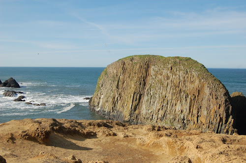
Now the fun thing about that one was that it was in that post I came up with a plausible explanation for a photo I'd taken moments earlier of a feature I thought, at the time, I understood, Elephant Rock:
I, like Silver Fox, am definitely thinking about what features are visible in the viewfinder before I press the shutter button. And one nice thing about digital photo technology is that it's easy to mark up and highlight the features I was looking at when I shot the image, as In the Neighborhood of the Splort:
And of course "The Splort" itself is likely my favorite photo I've taken on my new camera. I certainly did not understand WTF I was looking at with this one at the time, mostly because I was focused mainly on what had gone where, rather than looking at and thinking carefully about the faults that accommodated those motions. What I "saw" was a plug intruding down into the surrounding rock, and that just didn't make sense. So, get a picture of it.
A couple of other nice options with digital photography are the options to easily create panoramas, such the not-quite normal normal faults...
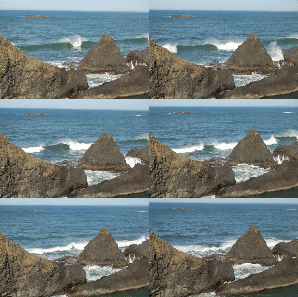
(this version has also been annotated) ...and animated gifs: Heeere's Water!
Snow Melt
My feeling about gifs is that they offer an ability to photographically illustrate another dimension beyond the two of traditional photography. Rotating the view can offer a visceral sense of the depth in a view, or as here, the third dimension illustrated is change through time.

So in the end, I think what influences my perspective as a photographer of geology is an imperative to communicate the nature of the planet we live on. The esthetic, emotional aspects are important to me, too, but I guess even if a shot is gorgeous, if it's not telling a story, or part of a story, it's not one I'll be likely to take.

Geo 365: April 13, Day 103: PNW Palms in the Breakers

Out toward the open end of Devil's Churn, so-called "sea palms" have evolved to thrive in one of  the most violent environments on earth: the breaker zone of the PNW's rocky coasts. Below the sea palms, against the right edge of the photo, a knobby cluster of mussels blends in well against the basaltic breccia bedrock.  Toward the bottom, barnacles and encrusting algae are other organisms that can cope with this rugged, battered habitat. As hostile as it looks from our perspective, there are many factors that make this an appealing spot for critters that can handle it: highly oxygenated water, high nutrient levels from upwelling, and a relative paucity of predators. Starfish are the main carnivorous predator, sea urchins the main browser. This zone is a bit too high- too often above the tide level- for either to be able to get to the area.

Photo unmodified. September 21, 2010. FlashEarth Location.

Friday, April 12, 2013

Geo 365: April 12, Day 102: Dana Peers Over the Edge

Looking west, out toward the ocean, from the end of Devil's Churn. It looks as if Dana is trying to get a decent shot of the sea cave that's directly below where I'm standing- I need to ask her if she got one. She also provides the best sense of scale of any of these photos. You can see that the rugged basalt offers decent footing, and there's a good, wide platform to walk the length of the chasm. One *can* walk out to the north end as well, and I have done so as a stupid undergrad, but I wouldn't recommend it. That side is steeper, less rocky, and more vegetation-covered. And as you can also see in this photo, a mistake could end in disaster. The water is unusually calm at this moment; it's more often violently swelling, shallowing and turbulent. It's also very cold. Due to upwelling during the summer months, it's actually colder then than during the winter season.

The long and short of it is that I really enjoy Devil's Churn; the geology is complex enough to be interesting, simple enough to figure out pretty easily, safe enough to be enjoyable, and dangerous enough to give the visitor that extra bit of thrill. I suppose you could call this Goldilocks geology: It's *just* right.

Photo unmodified. September 21, 2010. FlashEarth Location.

Thursday, April 11, 2013

Geo 365: April 11, Day 101: Churning Away

Looking toward the end of Devil's Churn, you can't really see the sea cave eroded out of the mountainside due to the way the shadow is falling. The photo I posted January 3rd shows the fault that created the weaker zone along which this feature was carved, and was pointed more or less toward where I'm standing for this shot. The current configuration funnels the waves' energy tighter as they pass through the churn. We were here at low tide, but at high tide, with rough seas, this can be a spectacular (and very frightening- at those times, I just stay on the stairway) spot. The sea cave gets almost explosive as the waves crash into it, and the grinding of the cobbles and gravel on its floor sounds like a subway, or some angry beast growling, down in the bowels of the earth.

Photo unmodified. September 21, 2010. FlashEarth Location.

Wednesday, April 10, 2013

Geo 365: April 10, Day 100: Basalt Breccia, Dike, and Turmoil

Looking across Devil's Churn to the opposite side, the exposure is pretty representative of this area: basalt breccia cut by numerous dikes. I'm guessing here, but the dike above is probably 12-16 inches across. The footing is pretty good in this area, with the sharply fragmented basalt, but green spots, where the spray supports algae, can get slick. And you do NOT want to fall in. On the plus side, I've never heard of such an instance.

Brightness slightly decreased, contrast substantially increased. September 21, 2010. FlashEarth Location.

Tuesday, April 9, 2013

Geo 365: April 9, Day 99: Cape Perpetua Visitor's Center

As we crossed the head which has the Devil's churn on its northern side, I shot this looking back to the southwest toward the visitor's center. It's a nice little facility, with all kinds of artifacts, including rocks from the nearby area. They also have some binoculars and telescopes to watch the ocean- the views from there are great, and at the right time of year- now to early May is peak spring season- you can see the whales migrating. There is a pedestrian tunnel under Route 101 near that building, connecting to a fine network of trails along this stretch of coast.

You can see the basalt bedrock at the top of the beach, and here, as at many, many locations along our coast, the elevated terrace/dune deposits atop the bedrock. In this case, the fact that the sediment is consistently sand-sized, and that cross bedding can be seen in some exposed surfaces, suggests that these deposits are stabilized dunes.

Photo unmodified. September 21, 2010. FlashEarth Location.

Monday, April 8, 2013

Geo 365: April 8, Day 98: Mini Churn

At Cape Perpetua, the coastal morphology is dominated by the erosion-resistant Yachats (pronounced "yah-hots") Basalt, leading to precipitous cliffs. A series of faults striking roughly perpendicular to the coastline has created fissures or crevasses back into these cliffs. It turns out I've only posted one photo from this area so far in this series, and that was from Devils Churn, on January 3. Above you can see an analgous, but much, much smaller version of the same basic landform.

Photo unmodified. September 21, 2010. FlashEarth Location. (It may be one of the other fissures in this general area.)

I dumped a full cup of coffee on my table, the floor, and my pants leg yesterday, and apparently the power supply cord for my new laptop was also a victim. I'm back on my old laptop, and even this short post, which would normally have taken me five to ten minutes, has already eaten up better than half an hour. It's extremely frustrating and irritating. With internet interactions, there is almost as much time spent in lock-up as functioning. A number of common letters, such as s, e,d, r, and l, are spotty about actually printing, so I'm constantly backing up to put them back in. I'm not even going to attempt to assemble the Sunday Funnies on this machine. I'll keep plugging on this series, but I expect it will tend toward shorter posts. Apologies in advance.

Sunday, April 7, 2013

Geo 365: April 7, Day 97: Islands of Seals (With Apologies to the Go-Go's)

A final view to the south at Seal Rock State Park. The head on the middle horizon is Cape Perpetua, and while I've posted a few photos from there in this series- I'll have to review to see which ones- I'm thinking I'll post some more in the coming week. The rock there is Yachats Basalt, which is from a different source and age than both the CRB here, and the Siletz River Volcanics that form the basement of the Coast Range.

I have realized, as I get older, that some of my most creative moments come when I'm not really awake- either dozing off, struggling to stay awake when I've over-extended myself, and most especially first thing in the morning, when I'm struggling to reassemble my shattered consciousness after a good night's sleep.

Yesterday as I woke up, I was pondering the possibility of a sheath of steam around the margins of the intrusion keeping the upper portion of Elephant Rock better insulated, thus creating the down-to-up cooling gradient. I said "creative," not necessarily "sensible." Though nothing about that feature is sensible, that guess just seems like a stretch to me.

But this morning, the phrase "ball-and-pillow," which I tossed out yesterday to somewhat acerbically compare this to a secondary sedimentary structure, was zinging around my head, smashing the carefully arranged glassware in my mind. Wait... what if it wasn't tabular? (I realized I've never defined that term- it means relatively large in two dimensions, and small in the other. So sheet or tablet-like.) In other words, neither a dike nor a sill. What if, like true ball-and-pillow structures, its overall shape was more like a horizontally-oriented cylinder?
Okay, it's crude and schematic, but in terms of plausibility, I'm happier with this than anything else I've come up with. I'm certainly not going to argue this is "correct," but it makes sense. And that's something of a relief.

This is one of the unexpected pleasures of this series: it forces me to look anew at things I've seen countless times before, and think about trying to make sense of things I've never really considered. The columns at Elephant Rock, for example, are a feature I've pointed out to others many times, but until two days ago, had never really thought about in terms of their perplexing orientation. And this was in fact the very first "geologic spot" in Oregon I visited, about a month into Spring Term of 1980.

Another one of my non-standard geologic principles is that of Geologic Time: "It took millions to billions of years to create some outcrops. Don't expect to be able to figure them out in a few minutes." Indeed, sometimes it can take decades to even recognize there's a problem that needs solved.

Photo unmodified. March 8, 2012. FlashEarth Location.

Oh, and in case you didn't get the obtuse joke in the title, here's the relevant video, and the cue, "misheard lyrics."

Saturday, April 6, 2013

Saturd80's: Icehouse Edition

The first two here are from the eponymous first album, Icehouse. Amusingly, the first song on that album is "Icehouse."

One of the guys I met at the dorm my first term at OSU, who later was a housemate, had this album. I recorded it to a cassette tape, and played it countless times over the years. "Sister:"

In 1988, a very odd movies named Young Einstein came out. I say odd, because while many of the gags were pretty stupid, you'd have to be pretty smart to get them- or to create them in the first place. When Young Einstein departs Tasmania to travel to Australia to patent his technique for splitting beer atoms (don't even ask), the following song plays, "Great Southern Land."

It wasn't until the advent of the internet- probably in a search in the last ten years ago or so- that I even realized that last one was off a later album by the same group.

Geo 365: April 6, Day 96: Lord of the Ring Dike

Looking a bit more southerly from Elephant Rock, you can see the general ring-like outline of the invasive dikes at Seal Rock State Park. The "classic" example of a ring dike on the Oregon Coast is at Otter Rock. I've only visited that spot once- it's one I should get back to- and the only thing I remember is that even as a wet-behind-the-ears newbie, the explanation offered sounded more like arm-waving than a reasonable idea. Something about a piston intrusion at depth, creating a circular fault, then injection of basalt into that ring. The fact is, even with years of geology behind me, that sounds almost more reasonable than what is apparently now believed- CRB flows onto unconsolidated sediments, then owing to their greater density, intuding down into them. Sort of a ball-and-pillow structure with lava.

When I was doing volunteer teaching for my "Geology of the Corvallis Area" class, I had some jokey additional "principles of geology," which I felt were both funny, and contained important elements of truth. One of them was the "Don't Tell" principle: "Don't tell the rocks what they can and can't do. They've already done it. Your job is to figure out how they've done what they've done."

All these years later, I still like that one; I can't say how many times I've peered at an outcrop, and felt tempted to say "But, but, but... you can't DO that!" But they did. Rocks do weird things, and I guess that's a big part of why I love them.

Photo unmodified. March 8, 2012. FlashEarth Location.

Friday, April 5, 2013

Geo 365: April 5, Day 95: Elephant Rock

Elephant Rock is the ambiguously-facing (north or south?) large rock at Seal Rock State Park. You can also see the raised terrace sand deposits in the foreground. The puzzle here is "Why are the columns oriented parallel to the tabular aspect of the dike?" and the answer is "I haven't a bloody clue." It would be easy to suppose it isn't actually a dike, just a tabular erosional remnant, but everything about this spot says it is a dike. My suspicion, which I can neither defend nor support with evidence, is that the nature of the hot CRB lava invading and injecting into the wet, cold sediments, led to an unusual cooling gradient that was down-to-up rather than sides-to-inside. But really what I'm saying is, once again, "I haven't a bloody clue." And, as I've said before, "I just don't know" is one of my favorite phrases in science: it implies a puzzle and an opportunity to learn something new.


Photo unmodified. March 8, 2012. FlashEarth Location.

Thursday, April 4, 2013

Geo 365: April 4, Day 94: Seal Rock Breaker

The thing that struck me on this brisk spring morning was not amazement that the rock would eventually wear away, but amazement that it was as durable and resistant as it is.

Photo unmodified. March 8, 2012. FlashEarth Location.

Wednesday, April 3, 2013

Geo 365: April 3, Day 93: Invasive Dike at Seal Rock

Jumping over to the coast, this is at Seal Rock State Park, the southernmost recognized spot where the Columbia River Basalt (CRB) flows reached the area of the modern coastline. To anyone with a background in geology, the phrase "intrusive lava" should sound like an oxymoron, but it's actually fairly easy to find along the northern Oregon Coast. When CRB flows reached the Miocene coastline, they invaded the underlying unconsolidated sediments, forming dikes such as the one we see here.

My mind spins when I try to imagine the implications of this and related landforms- I struggle to picture the landscapes it suggests. It implies that the Coast range simply didn't exist, only 16-18 million years ago. That alone is difficult to picture. It implies a lava flow capable of reaching a length of 400-500  miles, with a high enough temperature and fluidity that it was still able to intrude into wet, semi-solid sediment quite deeply. Again, hard to imagine. Finally, this area would have been ecologically much like today, perhaps a bit warmer- the Oligocene in Oregon was a transition period from a more tropical climate toward the modern temperate climate. Obviously, the flora in the path of the flow had no chance. But the panic and chaos among the fauna at the time, as the fiery flood arrived, is terrible to contemplate.

As I used to say to students about quite a number of disastrous geologic phenomena, "It'd be quite the sight to see. From low orbit."

Photo unmodified. March 8, 2012. FlashEarth Location

Tuesday, April 2, 2013

Geo 365: April 2, Day 92: Into the Setting Sun at Pilot Butte

It seems fitting that the last photo I took on this day is one of Dana walking toward the setting sun. Behind her (we're looking more or less east) are the Maury Mountains. I don't know much about them, but they're north of the Brothers Fault Zone (AKA High Lava Plains: see the last paragraph here for a more complete explanation), and based on other similar areas I've seen, I'd expect to see younger lavas of HLP affinity, overlying a basement of Blue Mountain-related rocks. The latter are a complex assemblage of late Mesozoic to mid Cenezoic accreted terranes, overlain by younger volcanics.

I'll choose a new topic for tomorrow, but as we close out this segment of Geo 365, I'll point out that everything I've posted from February 18, at Abert Rim, through today was a single day's drive- and we weren't pushing all that hard. There are portions of Oregon that have more diversity, perhaps, and depending on what "spectacular" means to you, maybe more of that, too. But there is an awful lot of amazing stuff to see in this lightly visited and largely ignored portion of the state.

Photo unmodified. August 20, 2011. FlashEarth Location.

Monday, April 1, 2013

Geo 365: April 1, Day 91: Pilot Butte Rose

April Fools! It's not really a rose:
I think the one that most blows me away is that Mt Adams, in southern Washington, is at least on occasion visible from here. Standing here, one is less than 500 feet above the flat ground of Bend proper, but that's enough to be able to see a peak 142 miles away. On an exceptionally clear day on Marys Peak in late winter of 1982, I think, I was able to see from Mt. Thielsen, near Crater Lake, to Mt Ranier in Washington- but that's nearly 4000 feet over the valley floor.

On the other hand, the elevation of Pilot Butte's crest, where this compass rose sits, is 4142 feet. The crest of Marys Peak is 4097 feet. So perhaps it's raw elevation rather than prominence that's important.

Photo unmodified. August 20, 2011. FlashEarth Location. (I can generally put the cross hairs in FE view within a few feet or yards of the location where I shot the photo; in this case it's within inches!)

Sunday, March 31, 2013

Sunday Funnies: Easter Edition

Because last year was a leap year, Easter falls on a Sunday again this year. That won't happen again for over 200 years!
This week's new find, Maximumble.
Zaius Nation
Made this one myself. Original image from here.
Another captioned by me, original picture from @BFSCR
Matt at Research at a Snail's Pace points out that the iconic animal of Easter should be the platypus. Brilliant, and I agree one hundred percent!
Please do yourself a favor, and go read the completely true story of how Jesus Marvin Christ got into, and out of, his crypt, at The Frogman.
Are You Talking to Meme?
 "Worst Easter Candy Ever" @LKWeaver
Imgur

And just as I was finishing up, one more on the Easter theme...
@LOLGOP
 
Blackadder
Wil Wheaton's Tumblr- click over for a gallery of artist's work, and some info.
"Honk!" Sober in a Nightclub (As an aside, I suspect this could be quite dangerous to a small animal. Please don't)
Blackadder
Surprise! Funny to Me
Senor Gif ("Solution" at the end- I certainly  didn't see the trick, so don't feel bad if you don't.)
Wil Wheaton's Tumblr
Funny to Me
The Oatmeal
Tastefully Offensive
Danziger Cartoons
Very Demotivational
Cheezburger
Funny to Me
Wil Wheaton's Tumblr
Bits and Pieces
"Hermione's glimpse into the future" Senor Gif
Tastefully Offensive (See also, "Myth Busted" at Sober in a Nightclub)
Blackadder
Maximumble
Bits and Pieces
Sober in a Nightclub
(Read the board's caption on the upper right) Bits and Pieces
"How I feel when I run into hostile park rangers, and I have adequate collection permits and permission" Geology is Hard
Very Demotivational
Maximumble
Amazing Superpowers
 "When I read the comments of science news posts on the internet" What Should We Call Grad School?
Funny to Me "Wove, twue wove."


The Frogman, Bee photos by John Kimbler [flickr]
Funny to Me
Tastefully Offensive- Be sure to wait until *just* before the crest of that first hill.
"When I realize the undergrads are coming back from spring break" What Should We Call Grad School (This will be funnier if you've see The Cabin in the Woods)
Bits and Pieces
Alphaville
Well, and 33 cents. The Far Left Side
A whole new take on "wind generator." Derpy Cats
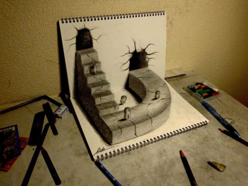
Pairs of 2-D drawings, ~perpendicular to each other, create uncanny illusion of 3-D. Gallery at Funny to Me.
Tastefully Offensive
Sober in a Nightclub
Indexed
Matt Bors
You're All Just Jealous of My Backpack
Fake Science
Criggo (biting back the Sarah Palin jokes...)
Funny to Me

The solution to the "infinite chocolate" gif, earlier in the post, from Tastefully Offensive.