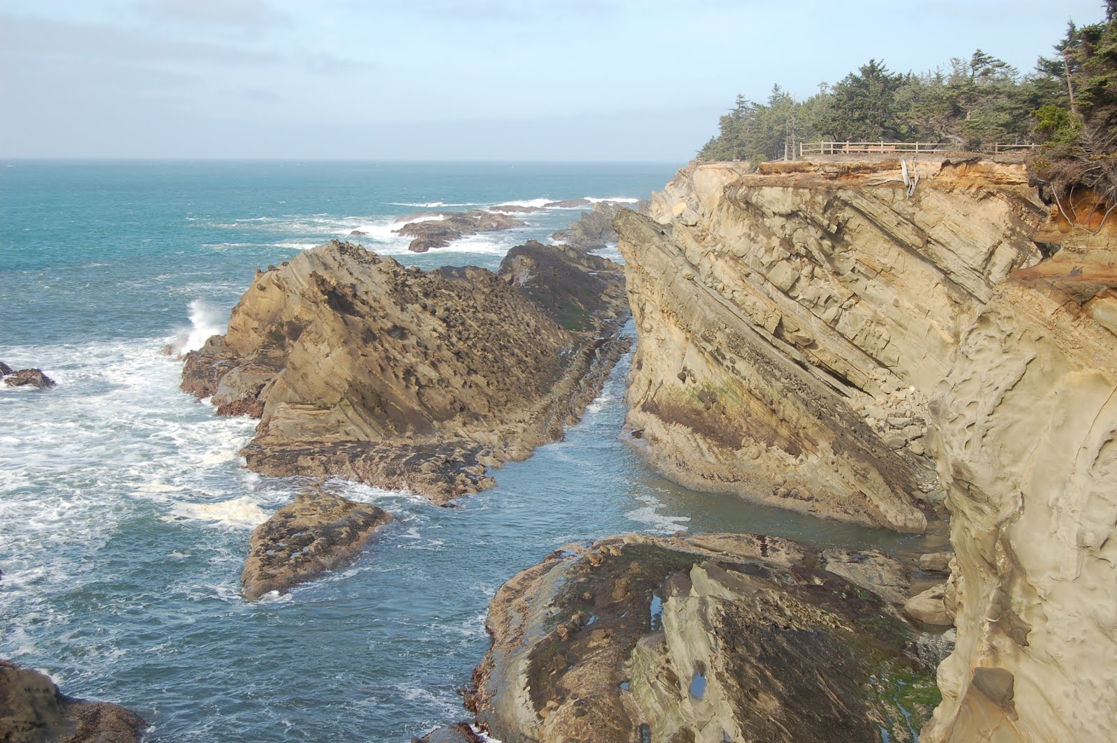
Thursday, April 12, 2012

March 2012 Coastal GeoGalavant, Part I

I got a request for the locations and overviews of the stops Dana Hunter and I made on our rocking around Oregon a moth ago. Instead of locations, I've added FlashEarth links, which have detailed Lat-Long information attached to them. Additionally you can zoom in to surprising resolution, or out to get a better sense the where the spot is in relation to other things.

Note: Dana and I pointedly planned this trip to coincide with a series of negative tides (those with low water elevations below the average of the lower of the two daily low tides) specifically so we had good, safe beach access, and a maximum extent of time to look at rocks exposed there. DO NOT takes chances with the Pacific Ocean. It's anything but "pacific," and it's very cold here in the PNW. Even the strongest and healthiest have little time to survive if they unexpectedly find themselves in the water and can't quickly get themselves out.

Day 1 (half day)
Stop 1, Yaquina Head- Columbia River Basalt reached the location of modern coast in a number of spots. Yaquina Head is one of them. Cobble Beach, a lovely beach of polished basalt cobbles and tidepools, and Quarry Access, a well-intentioned, but poorly geologically thought-out project to provide wheelchair access to tidepools. The inevitable result, which I predicted correctly just a few weeks after it opened and I visited it the first time, is reason enough to go down to the "tidepools" here. Aside from the geology, the visitor center is quite nice, and the views from the cliffs near the lighthouse are epic.
http://www.flashearth.com/?lat=44.674502&lon=-124.073795&z=15.1&r=0&src=msl
Looking north from near the lighthouse.
Looking SE from lighthouse parking area, down onto Cobble Beach; Newport, OR in the distance.
Cobble Beach
Quarry Access "tidepools." An abandoned quarry was modified, pathways added, and opened to the ocean in hopes of creating a unique spot that allowed handicapped access to tidepool viewing. Unfortunately, I don't think any geotypes were involved. It was blatantly obvious from the outset that the site was an excellent sediment trap, and would not permit the high-energy wave environment necessary to create and maintain tidepools.
Columns in Miocene Columbia River Basalt in the Quarry Access walls.

Stop 2, Beverly Beach State Park- Fossiliferous cliffs in Miocene Astoria fm- walk under highway bridge from day parking then turn left (south). Mud/siltstone has scaphopods that are difficult to collect; nicest fossils are in sandstone, past the muddy cliff. Collecting (I just learned on this trip) is technically illegal here. Sadly, I didn't see that until after we'd returned to the car. Oh well.
http://www.flashearth.com/?lat=44.7294&lon=-124.05735&z=15.3&r=0&src=msl
A sweet little gastropod which my have followed me home
A resistant, well-cemented sandstone weathering and eroding along its joints.
Same spot as previous, looking north, with Dana Hunter for scale.
A typical fossiliferous boulder at Beverly Beach. Lens cap is ~52 mm. Scallop-looking critter is a pecten.

Stop 3: Devil's Punchbowl State Park- 1st, drive to lot at end of headland, for a nice view down into the namesake punch bowl. Then turn around and drive the couple blocks or so to the beach access parking between B and C Avenues. We went down the south cove, which was every bit as awesome as I remembered- haven't been down there since late 80's. North cove is a bit more of a walk (less so if you park in the overflow parking off 2nd, west of C), but also has good geology exposed, plus, if you go during a good tide, you can get an interior viewing of the punchbowl. If you choose to do this, keep a very close eye on the water... people have been trapped there. Don't recall anybody dying, but it's scary and expensive. Yes, they pass as much of the cost on to the rescued as they can.
http://www.flashearth.com/?lat=44.747153&lon=-124.064289&z=17&r=0&src=msl
Devil's Punchbowl- color/contrast tweaked to bring out details down in the hole, so lip is completely washed out.
Looking west, toward first point, south cove, Devil's Punchbowl State Park.
Clastic dike, not too far from base of stairs, south cove, Devil's Punchbowl State Park.
Cute little pair of faults a little ways further along from clastic dike.
View around the first point in south cove...
...where the rock is full of marcasite nodules like this one.
Sea cave around second point in south cove

Day 2:
Stop 1, Seal Rock- Quick stop for overview from terrace, didn't go down to beach. Nice beach, but geologically there are more interesting places. Major importance of this spot is that it's the southernmost spot known where CRB reached the location of modern coast.
http://www.flashearth.com/?lat=44.496849&lon=-124.08329&z=16.4&r=0&src=msl
View to the north from top of elevated terrace at Seal Rock.
View to the south. Between these two views, you can see this is an "invasive" dike. A subaerial flow of CRB reached unconsolidated sediments at the Miocene Coast, then intruded down into them. This is not uncommon along the central to northern Oregon Coast, but it is a sort of odd situation; "intrusive lava" ought to be an oxymoron, but there it is. It was beginning to be suspected, during the 80's when I was an undergrad, that this was indeed the case, but by the time I finished up, it was only accepted firmly for some of the more northerly occurrences. At this point it seems to be accepted for most of the isolated, younger basalt headlands north of the Yachats Basalt headlands, which can be seen on the horizon in the distance in the second photo. (Also, to try to avoid confusion, the basement rock of the Coast Range is Siletz River Volcanics, sea floor and oceanic plateau basalt, and it shows up in some outcrops along the northern coast too, but it's older, Eocene, and shows typical oceanic basalt features such as brecciation and pillows.)

Stop 2: Coming down off headlands toward Florence, there are some pull-outs with nice views out over the Dunes. Another quick stop to admire the scenery and snap a few photos.
http://www.flashearth.com/?lat=44.100933&lon=-124.121103&z=12.4&r=0&src=msl
View to the south, coming down off Yachats Basalt headlands, looking south over the dunes.

Aborted stop, but nice and recommended: Honeyman State Park. In the Oregon Dunes, wind-blown sand has blocked numerous streams, so there are numerous fresh-water lakes, which drain to the ocean only by groundwater movement. Cleawox Lake at this park is a good example. The forest here is also beautiful, and the dunes are some of the best I knew of until I found Eel Creek... though at my age, I'm less thrilled than I used to be at climbing up hundreds of feet of loose sand.
http://www.flashearth.com/?lat=43.929301&lon=-124.111111&z=14.2&r=0&src=msl

Stop 3: Oregon Dunes Overlook roadside rest area- Not the best place to see Dunes, though my nephew had a blast running and falling down them here when he was out a few years back. The outstanding thing to see here is the various stages of succession from open sand, to grass, to low shrubs, to larger shrubs and shore pines, to mature Douglasfir forest. From the overlook viewpoint, you can see examples of each of the stages from one spot, and see just how disorderly and patchy the process really is, while at the same time, being able to clearly see the progression. Perhaps the only thing missing is a clear example of forest being swamped and killed by advancing dunes, starting the process anew. But you can see that at the next stop...
http://www.flashearth.com/?lat=43.833305&lon=-124.151551&z=17.3&r=0&src=msl
Looking more or less south from dunes overlook: nice stand of isolated, mature Douglasfir.
Looking out toward coast, dunes overlook.

Stop 4: Eel Creek- Park at the day use area, which I'm pretty sure I have in the cross-hairs. (The campground entrance is about a half mile further to the north, and is a nice spot to stay with kids. On field trips with HS students, we've stopped at other places and this can be a convenient place to know about.) It's about a half mile walk in through lush coastal forest, and you come out onto the open dunes rather abruptly. DO take a moment to look around and note prominent landmarks... it's easy to lose your bearings on open sand, especially if you get out of view of the spot at which you came in. This location features some of the nicest dunes I've seen in my life. The large dune to the south of the trail's egress into the sand is relatively easy to get up if you walk to its eastern end, then follow the ridge crest up. From the top, the view to the south reveals coastal forest being overrun by advancing sand, as well as seemingly endless ridges of it out into the distance. Extremely mesmerizing and memorable.
http://www.flashearth.com/?lat=43.583814&lon=-124.18492&z=15.3&r=0&src=msl
Emerging abruptly from the forest onto the sand.
View to the southeast of forest being killed by advancing dune- though as you can tell from the grasses established along that slipface, the process is sporadic, not a steady, gradual one.
View south. Note slumping of slip faces on dunes in mid-distance.
Dana looking at some sweet cross-bedding.
Sand saltating across the top of the dune. Yes, it was windy.

Stop 5: Shore Acres State Park- Coos Bay (the bay itself, not the town) lies on the axis of a progressively folding syncline; younger beds are less steeply dipping than older beds. The triplet of state parks along this section of coast are my favorite Oregon coast locations- and I love the coast, so that's no small compliment. Shore acres has numerous features to explore. You can get to sea level in the south cove, but for the most part, I've been content to simply explore the top of the terrace here. The elevated terrace, incidentally, shows a noticeable increase in elevation from north to south, from Sunset Bay to Shore Acres, to Cape Arago, respectively. The views are breathtaking here; a shot taken near the shelter house is the first photo I've preferred to blank, undistracting gray as my desktop image. Cannon Ball Rock is covered with large concretions, and there are some lovely examples of tafoni weathering on the platform north of that. Looking down into the cove from that platform at low tide, one can see several faults criss-crossing the new wave-cut terrace. If you want to spend some time not doing geology, the gardens are very nice. However, just strolling the path along the cliff and enjoying the scenery can burn plenty of time too. This is the spot to spend your time when the tide is still up; the other two are best visited at low tide.
http://www.flashearth.com/?lat=43.324228&lon=-124.386203&z=15.6&r=0&src=msl
Looking north toward Cannonball Rock- my current desktop photo.
Dana on walk around to Cannonball Rock, giving sense of scale to fence behind her, and in turn to fence both in the distance and in the previous photo.
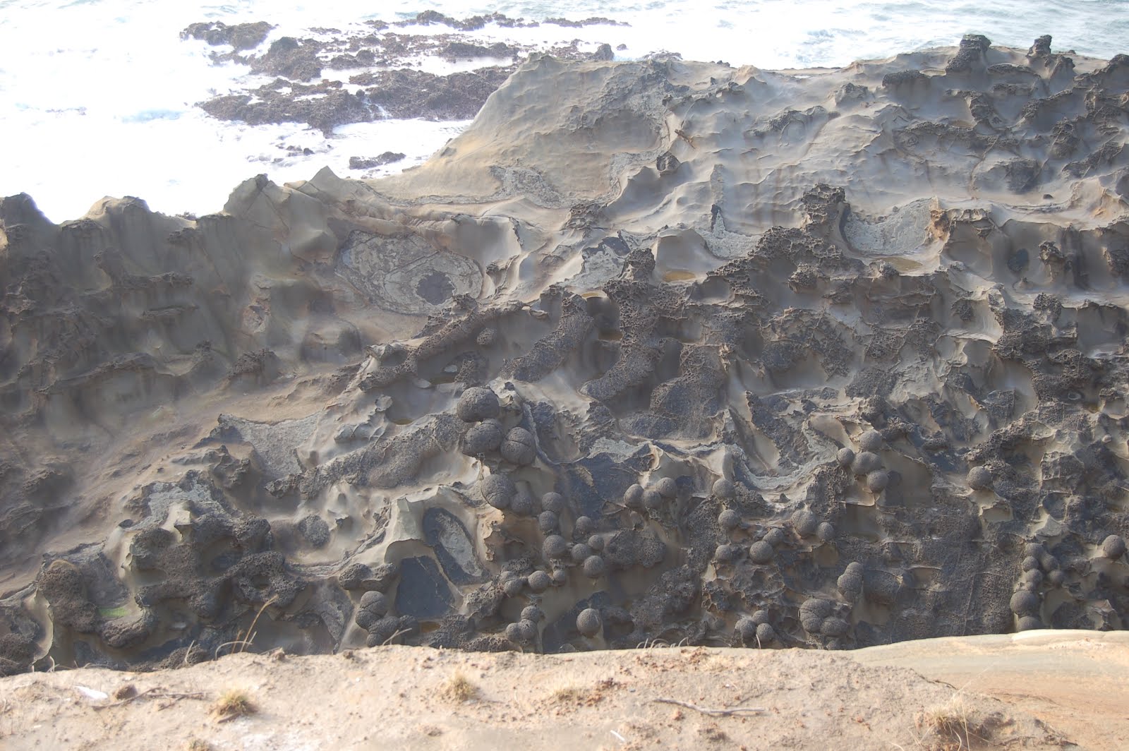
Large concretions give Cannonball Rock its name.
Tafoni weathering on terrace surface where younger sediments have eroded off, exposing tilted bedrock, south of Cannonball Rock.

Stop 6: Simpson Reef overlook- Most people want to look at the seals and sea lions that haul out on these offshore rocks. Geologists take one look at that zigzag pattern and go "Ooh! Plunging syncline-anticline pair!" Can't remember which is which right now... I'll look it up later.
http://www.flashearth.com/?lat=43.312404&lon=-124.395659&z=15.6&r=0&src=msl
Simpson Reef

Aborted Stop, but highly recommended: Cape Arago- we were getting pressed for time, and choosing between walking down yet another flight of stairs to spend low tide at Cape Arago, or driving back North to Sunset Bay was a no-brainer. Structurally though, and in terms of diverse geology, Cape Arago is the gem of these three parks. Ideally, one should set aside two low tides at this park, one for the south cove and one for the north cove- I don't think the middle cove is safely accessible. North Cove: some great folds, enormous cut-and-fill channels, some kewl sed structures. South Cove: some excellent sed structures, coalified driftwood, hidden but fairly easily inferrable fault. Good tidepools. The FlashEarth imagery does a nice job of highlighting the erosion into criss-crossing faults on the sandstone headland itself.
http://www.flashearth.com/?lat=43.306056&lon=-124.398947&z=16.5&r=0&src=msl

Tuesday, April 10, 2012

PNW Survival Tips And Still Not Dead Yet

Apologies for the long hiatus here. It is intended to be "just" a hiatus, but until I can unsnarl the intertangled problems of an aging computer, Adobe updates devilishly designed to lock up the system, and Blooger updates requiring me to learn new interfaces regularly, it's simply more fight than I want to cope with. I set this up for my own entertainment, and to share my amusements with others. When it has me grinding my teeth in frustration, it's not worth it.

However, I did want to archive today's Twitter tear in a place where I could find it, and others could enjoy it too. So without further ado, "Pacific Northwest Survival Tips:"
  • We divide our fresh water into three categories: ground water, surface water & air water: water that is currently falling.
  • The outdoors is there to enjoy. Careful though. It will chew you up and spit you out dead if you don't use common sense.
  • Be careful. We're coffee snobs. But you already knew that, right?
  • We still support and have small independent bookstores. Yeah, we're retro like that.
  • Newcomers have about a one month grace period to learn correct pronunciation of names. Except Orygun. No grace on that one.
  • We don't believe the world will end in 2012. We believe world went into an endless coma in 1980 when Reagan was elected.
  • If anyplace in the US moves to metric, it will be PNW snow reports. Because snow amounts near 1000 inches are just silly.
  • Yes, walking around in shorts, tee shirt and flipflops is possible in winter, and will get you looks. Contemptuous ones.
  • If we had a state gastropod, it would be the banana slug.
  • People here do weird things just to be different. Like anywhere else. Unlike other places, we don't make a fuss about it.
  • Contrary to widespread belief, "The Earthquake Forecast" is not part of the evening news. But we're working on it.
  • Bend has grown enormously, from small town nearly impossible to get through to large city nearly impossible to get through
  • Salem is known for the golden pioneer on the State Capitol building. And not much else.
  • Reasons we tell CA they can't have our water: agriculture, salmon, hydropower. Real reason: craft beer.
  • Recently, a healthy population of moderate Republicans was discovered here, to much astonishment. Please don't disturb them
  • "Drain Oregon" is a town, not a demand. Likewise, "Boring Oregon" is not a description.
  • *Real* hipsters just *say* they hang out in Portland so the would-be hipsters can't find them.
  • You can tell it's spring in Corvallis when the fragrance from the dairy barns overwhelms that of the flowers.
  • The spirit of the sixties didn't die. It retired to Eugene.
  • Roads can be narrow and rudimentary on the east side, because sand people always drive single file to hide their numbers.
  • We actually *do* have real winters here, but we keep it in mountains and out of most peoples' ways.
  • We're actually quite sanguine about all our volcanoes. Don't expect them to erupt, but looking forward to show if they do.
  • A gift idea for a west side child that guarantees endless frustration? A telescope.
  • Do not tell a PNW woman how to manage her reproductive health. She'll sic her bear on you.
  • Another true fact: People on the east side sometimes get a malady called "sunburn." West side doctors frequently misdiagnose it.
  • True fact: 2/3 of PNW is much drier than the midwest. We call it "the east side," and most people have never heard of it.
  • When we refer to "undesirable immigrants," we're not talking about our respected Latino workers, but Californians.
  • Half the traffic is enormous SUV's, trucks and Hummers. Other half is hybrids. Go figure.
  • Ignore the frequent liberal fads. They'll inevitably fade away in a few decades. Or not.
  • Hazelnuts and filberts are the same thing, but damned if I can ever remember which name we're "supposed" to use here.
  • That freakishly bright orb in the sky? That's the sun. Yeah, it *is* weird.
  • We're the largest exporter of waterfall photos in the world.
  • Our "cities" would mostly be considered "towns" elsewhere. And we like that.
  • That's not black paint in the older apt you're checking out. It's mold.
  • OR state rock is thunderegg, but ought to be basalt.
  • Learn to use a map. GPS is Darwinism in action. It *will* try to kill you in remote areas.
  • Traveling to coast during winter, watch for fish. When you see them, you're there.
  • Do not tease the scrub jays. They will remember you, and make you sorry you're alive.
  • If you're from another part of the country, you won't like it here. Really. Take my word for it.
  • Don't blink during summer time, or you'll miss it.
  • Harumphing about people carrying umbrellas for our light drizzle misses the point: umbrellas *ensure* it's only light rain.
  • Don't face eastward too long, or your left side will get all mossy, and you'll sprout ferns there.

Friday, October 28, 2011

Test Post

I haven't been able to get any Blogger pages to load for at least the last two days- not even my own blog. Twitter inquiries lead me to believe this is just me, not an issue with Blogger. I'm still seeing posts in RSS, but for those who clip their posts, sending just an intro snippet to their feed, I can't click through to read the rest... or rather, it won't load. I can get to the "create post" page, though, so I'm testing whether I can still post, and if doing so will allow me to get to OTI.

Tuesday, October 18, 2011

Volcanic Ramblings Part 6: Cascades Slop Over Into Basin and Range

We managed to consistently get started at a decent time each day of the trip, aiming to gather for breakfast at 8:00. Since we had driven about an hour south from the turn-off to Crater Lake, that meant we had to drive an hour north- though I recently realized there IS a more direct, probably significantly shorter route that would have taken us to the SW entrance. But wait'll you see the juicy outcrops we would have missed in that case!

Descending into the Klamath Basin, numerous ~N/S normal faults have opened up some terrific exposures I had never bothered to look at carefully- though the next one (after this) in particular is one I've wistfully watched as I sailed past it more times than I care to count over the decades. But here's the thing: the rock is steep, not particularly competent, so mass wasting into the road is commonly a problem, route 97 is sort of shoehorned in there where it fits, often with little space for pull-outs or break-down lanes... and it's a fast, busy and dangerous road. So opportunities to geologize need to be chosen carefully, with an eye toward safety.

All that said, we did find a few pre-park stops which, though they chewed up and spat out enormous amounts of precious time (the commodity which was in shortest supply for the whole trip), were definitely worth it. For most of the stops on the trip, I tried to remember to take a shot or two of helpful landmarks for anyone else who would like to check the spots out for themselves someday, and so I could more confidently and precisely find them in Flash Earth. The lead photo above is the intersection of Algoma Road with Route 97. We were able to get off the road, park in a pull-out on the south side, get behind the Jersey Barrier (which was very nice to have between ourselves and traffic), and walk a hundred yards or so south to an interesting-looking face we had noticed only moments before.

Here's the first shot of the day ( Note that all the photos in this series will get much larger with a click.):So what are we looking at? Well, that there is an itty-bitty normal fault in poorly sorted, extremely immature volcaniclastic sand (mostly) and silt. The grains looked to be mostly lithic, which is why I describe it as "extremely immature." The offset looks to be about an inch. Here's a view from a different angle:Isn't that purty? I'm quite fond of sed structures, both original and soft deformation, so I keep an eye out for them at stops like this. Not much of note at this one, but enough to convince me this stuff was reworked by water, not just air fall ash. (Obligatory admission: I'm no expert, and I'm always open to correction and/or questioning.)
Backing off from the same spot, with the lovely Dana Hunter for scale, you can get a better sense of the over-all look of the outcrop, and see that the fault is roughly parallel to the cliff face, suggesting this is a subsidiary fault to the much larger one that created this escarpment.Looking a bit farther along, there's a lens of very dark sediment that I took to be a small cut-and-fill structure at the time, but it occurs to me it might be a small channel from near the start of this sedimentation cycle. The next unit down is a brick red layer that looked as if it might be a thick ash-fall unit. Looking south along the face, below, it's quite striking. But at the far end, you can see the same kind of stratification as above the brick red stuff.
Walking south, down-section, more of the same under the bricky stuff...
Turning to look north, yep, it's pretty clear that structurally, we're in basin and range. I would guess (and later 65 mph reconnaissance geology seemed to confirm) that the sorts of rocks and sequences we're seeing here would be up there, too.Below, a block of stretched-vesicle mafic rock that fell from a lava flow above the sediments first shown with the fault...
...and a coarse cobbly layer in the lower section of sediment.
So what can we say about this environment (dons semi-irresponsible speculation helmet)? Well, it's very clearly dominated by a nearby source of volcanic rocks... oh, I didn't show you the view across the highway yet, did I?That'd be Mt. McLoughlin, the southernmost major Cascade peak in Oregon. (I doubt that particular volcano contributed much to this outcrop, though.) But I have to admit, I'm not very confident describing the depositional environment. I'm guessing that we're looking at a braided stream drainage, mostly choked with ash, but with larger channels carrying flows competent enough to move larger boulders. The material is too coarse and poorly sorted to be lacustrine (as the modern-day lake across the road) but I'm not seeing enough in the way of cross bedding and channel features to feel comfortable with what I'd consider a more typical meandering fluvial environment. There are quite a few flows in between thick piles of sediments, so we're not so far from the vents that sufficiently fluid lavas couldn't reach this spot, but they're a fairly small proportion of the pile... less than a quarter for sure, maybe closer to 10-15%.

In terms of age, I really don't know, but I'd bet pre-Pleistocene, because the magnitude of the fault offsets (which post-date the sedimentation) would require at least one or two million years.

One last shot, taken as we crossed the causeway in the lead photo, with a question for Callan Bentley... what was the term for a ramp between two vertically offset blocks? You mentioned it in your posts on structure in the Bishop Tuff. Followup: Callan responds swiftly with the response "relay ramp." That there below is one.

Sunday, October 16, 2011

Volcanic Ramblings Part 5: Lotsa Lakes

Looking across Odell Lake to Diamond Peak

I have read several times, in sources that look to be reputable, that the rate of ecological change from the Cascade Crest down into central Oregon is one of the most rapid in the terrestrial (as opposed to marine) world. I'm always suspicious of any claim of unique extremity- who says it's the biggest/tallest/deepest/smallest? But if you watch the change in trees and underbrush from Salt Creek Falls to route 97- the N/S backbone of central Oregon- it really is quite amazing how rapidly and thoroughly the forest changes, not just once, but multiple times. Just west of the crest, I would guesstimate annual precipitation is around 150 inches per year; by the time you get out onto the east side apron, it's closer to 25. The dominant trees grade from enormous DouglasFir, with lush and abundant undergrowth, to Ponderosa Pine, Lodgepole Pine, then sagebrush and juniper scrub.

Geology? Oh, my, yes! The presence of the Cascades creates a barrier to moisture coming in off the Pacific; not only do the mountains catch a large proportion of that moisture, but air descending the eastern slope is, well, descending. It warms adiabatically, with the result that air masses moving into central Oregon are most often capable of holding more moisture than when they went over the pass. Which means they don't drop any more moisture. In this case, the mere presence of all that geology has a profound effect on the types of vegetation that can grow, compete, and reproduce in different parts of the east side.

As an aside, much of central and eastern Oregon is referred to as "High Desert," both colloquially and technically; it bears pointing out that strictly speaking, "deserts" receive 10 inches or less of precipitation per year. My understanding is that the Alvord Desert, on the east side of Steens Mountain, does meet this criterion, but little if any of the rest of Oregon does. More accurately, most of the High Desert is semi-arid grassland, but that just doesn't have the same ring, does it? So High Desert it is.

Not to rain on the parade, though, I think one of central Oregon's best-kept secrets is that there's much more water than I think most people realize... which means, in turn, more vegetation and wildlife than they might guess, as well. Yes, there are stretches that can seem barren (to the unaccustomed eye), and there are lots of glorious "dear gawd, look at all those nekkid rocks" vistas, but there's water, too, and lots of birds.

I had planned to spend the first night in the Chemult area, and had used the old Google machine to check that were indeed hotels in the little town. Oops. Without paying very close attention to where, exactly, said lodgings were, you know, located. There were a couple of ramshackle sorts of huts, members of the Bates Chain of Fine Accommodations, if you catch my drift.

So we put in an extra hour of driving to get to Klamath Falls.

As we rounded Modoc Point, we had a grand view of Upper Klamath Lake... ...and a short distance later, took advantage of a pull-out for a more lingering view.
Don't let all that sparse eastern Oregon water distract you from the fact that it's beginning to look a lot like basin and range. If I were asked to stick a tack onto a US map at the northwestern-most corner of that physiographic province, it's fun to imagine an enormous steel pillar suddenly splashing into existence somewhere out in that puddle.
Our diversion to K-Falls had some downsides and caused some later logistical problems, but also led to some fortuitous stops which we otherwise wouldn't have made. (Dana has already posted on one of those from the next day.) All in all, things worked out well; it was a good first day.

Saturday, October 15, 2011

Volcanic Ramblings Part 4: The East Side Apron

The Oregon Cascades are conventionally divided into two N-S sections: the western Cascades, which start as low foothills on the eastern margin of the Willamette Valley, then rise to quite respectable heights before sloping down to the High Cascades. I know that sounds oxymoronic, but it's an accurate description. On route 20 in particular, one crosses two very well-defined passes. You may recall this diagram from my post on Salt Creek Falls:
The Western Cascades is older, ranging from roughly 35 Ma to 5 Ma. The combination of our wet PNW climate, the fragmentary nature of much of the rock, recent glaciation, with the lack of ongoing volcanism means that the Western Cascades have been deeply incised. Indeed, some of the canyons through the area are awesome, and the Western Cascades overall are far more precipitously rugged than the High Cascades- with the exception of some of the big stratovolcanic peaks.

The High Cascades, as implied above, are younger, from about 5 Ma to present. In a few areas, recent glaciation has cut deep canyons well into the High Cascades platform, but overall, the province is a surprisingly gentle swell, punctuated with a relative few peaks that rise another 5000 feet or so above the ~5000-foot pass levels.

The moniker I applied in the title, "the East Side Apron," is entirely my invention, and is not used in broader literature, as far as I know. However it does a good job of expressing my perception of descending eastward out of the mountains toward Central Oregon: a very smooth and steady decline. There are exceptions, of course, but by and large, the east flank is exceptionally gentle. It gets comparatively little precipitation, so erosion is subdued, glaciation was much more moderate than on the west side, and the prevailing winds are from the west, so tephra-rich eruptions regularly cover the landscape with inches to feet of ash and debris, smoothing it out.

One of the more recent large eruptions in Oregon, that of Mount Mazama, is easily recognized in many road cuts in the central part of the state; when coming down from Willamette Pass on route 58, I always point it out to my traveling companions, and if interest warrants, make a stop. The general area where it becomes too obvious to miss is near where the Crescent cut-off takes off to the east near Odell Butte.
Mazama ash and tephra has a distinct creamy-yellow color; its coarseness varies, becoming finer with distance from Crater Lake. Where roads have been cut into and through it, you can see that it has a consistent thickness in a given location, but that unlike a bed of sedimentary rock, it is not horizontal. It follows the shape of the landscape.
In fact, after bringing this odd layer to Dana's attention, it only took a couple of prompts, "Look at the way it's following the landscape," before she let fly with a squee and wildly started scanning for the first safe pull-out she could find.
(lens cap is ~52 mm) As she notes in her description of this stop, the dark cinders are from winter time road gravel, but there's no problem finding as many pieces of pumice as you want to carry away.
I ended up with maybe 7 or 8 of the little buggers; I wanted to stop later to get a couple of head-sized chunks off the roadside near Chemult, but that ended up not happening. Another time.
The best part of this stop? Dana's non-stop squeeing and exclamations.

Wednesday, October 12, 2011

Misquotes

Many years ago, Omni Magazine ran a reader contest for best (i.e. funniest) misquote. I split my sides reading the resulting entries, but lost my copy of that issue, and have not been able to find it online anywhere. Today in honor of that long-lost genius, I started posting some of them on Twitter then just kept going. For archival purposes, here is the list thus far. Items I know I first saw in Omni are marked (O), and some have been around for years. Most were freshly half-baked this afternoon.
  • Asking Peter to pay Paul 
  • A waist is a terrible thing to mind. 
  • Every cloud has a soggy liner. 
  • Don't look a gift horse in the ear. 
  • 87 years ago, our four fathers bought a fourth country... 
  • When in the curse of human events... 
  • Beggars can't be boozers 
  • Smart as a peacock (O)
  • Angry as a hatter (O?)
  • A man who lives in a glass house should not throw orgies. 
  • An apple a day will get you kicked out of Eden right quick. 
  • A penny saved is still just a penny.
  • One if by lan, two if by C 
  • She's the cantaloupe of my eye 
  • Romeo! Romeo! Why fartest thou, Romeo?
  • A bird in the pan is worth two in the fridge 
  • Time and tide will turn eventually 
  • An object in motion will remain in motion in an equal and opposite direction. 
  • Wife-eye hot zone
  • 'Scuse me while I kiss this guy 
  • The road to hell was paved with the best inventions 
  • RT @eruptionsblog @lockwooddewitt Man, you really need to get all your horses in a row. 
  • Eyeplastics (O)
  • Toothglue (O)
  • A rolling stone gathers no wool.
  • Half of one, six dozen of the other.  (O)
  • To be or not to be, those are the parameters. (O, grand prize winner)
Language is so much fun!