Sunday, February 9, 2014

Sunday Funnies: Olympic Opening Edition


Bits and Pieces
Medium Large
Bizarro
Bits and Pieces
"Whatcha thinkin' 'bout?" "Oh I dunno.. motherfuckin' stuff, I guess." Sofa Pizza
Dork Tower
Are You Talking to Meme?
Wil Wheaton
Channel Ate
Savage Chickens
Far Left Side
The Chat Noir
Corn on the Goblin
Funny to Me
Bizarro
Blackadder
SMBC
Buttersafe
Darius Whiteplume
Bad Newspaper
Sofa Pizza
Dork Tower
See Mike Draw
What Would Jack Do?
Texts From TNG
Bits and Pieces
Bits and Pieces
Tastefully Offensive
Happy Jar
Are You Talking to Meme?
Texts From TNG
"When I grade Intro. to Geology exams and 1/3 of the class calls basalt a sedimentary rock" Geology is Hard
"Death from above" @Caleb Wilde

Geo 730: Feb. 9, Day 405: Outside the Interzone

Okay, one more of these self-indulgent meteorological mineralogy photos: this is my home-away-from-home, the Interzone. The snow started melting yesterday, with a fairly steady, but light, just above-freezing rain. The roads are now rutted slush, and especially for low-clearance vehicles, driving looks as treacherous as it's been over the last few days. Improvement is on the way, but conditions for the time being are not good.

Photo unmodified. February 7, 2014. FlashEarth Location.

Saturday, February 8, 2014

Geo 730: Feb. 8, Day 404: Ground Not Found

I saw "404," and thought, "what couldn't be found?" Well, obviously. Many people have been skiing and snowboarding around town the last couple days, thanks to our 18 inch coating of white mineral grains, and as I commented to @GeoHols earlier, "It's gone beyond troublesome to obscene to freaking hilarious. Not a huge fan of snow, but have to admit I'm enjoying this." The very best was Thursday morning, when a guy on skis was being towed by his dog. He was passing the vehicular traffic.

Photo unmodified. February 7, 2014. FlashEarth Location.

Friday, February 7, 2014

Geo 730: Feb. 7, Day 403: Meteorminerology and Geology

 Technically, snow is simply a pile of mineral grains. A mineral is "a naturally occurring, inorganic, crystalline solid with a fixed composition, or a composition that varies within a fixed range." Snow (and ice of any kind) meets each criterion of that definition; it is a mineral. And man, oh man, have we a pile of mineral grains in Corvallis right now. I'm guessing about 15-16 inches, rivalling the deepest snow I've ever seen here. As sort of a meta-treat, we're looking at the back side of Wilkinson Hall, the Geosciences building on the Oregon State University Campus. Beyond that is Burt Hall, the Oceanography and Atmospheric Sciences Building. Together, the two house much of CEOAS, OSU's College of Earth, Oceanographic, and Atmospheric Sciences.  (I'll head back to SE Oregon in a day or few, but this snow is pretty amazing, and I can't pass it up.)

Photo unmodified. February 7, 2014. FlashEarth Location.

Thursday, February 6, 2014

Geo 730: Feb. 6, Day 402: Lahars!

A "lahar" is a volcanic mud and debris flow- volcanic in the sense that the dominant clast type is volcanic in origin. They may or may not be associated with on-going volcanic eruptions. As we'll see in coming days, there are at least two lahars in this panorama, possibly three or even more. Their compositions overall are similar enough that, with the exception of the finer-grained channel fill to the upper left, it's not easy to make distinctions. On the right edge, we can barely make out some finer-grained, yellow-to-orange ash tuff beds, which are gently dipping to the left (NNW, if I have the location right.) between the channel on the right and the beds on the right, is what I'm for the time being presuming is a single larger lahar deposit. I say "for the time being" because I may notice something that indicates otherwise as I scan over these photos from 2 1/2 years ago.

Speaking of "2 1/2 years," that's plenty of time to forget details, like the location, for example. The closer I look at the indicated FlashEarth location, the more confident I feel I've got it right, but I'd be remiss in not admitting I'm still a little uncertain. For one thing, it's farther east and closer to Adel than I recalled.

Photo stitched in HugIn. August 19, 2011. FlashEarth Location.

Wednesday, February 5, 2014

Geo 730: Feb. 5, Day 401: Wave Goodbye

Actually, I was probably trying to block the glare from the sun as I peered up at the open pits shown in yesterday's photo, judging from the apparent direction of my gaze. This is an interesting spot, unique in the US, which is probably little-known, and certainly not well remembered. While visitors can't get a very good sense of the now-defunct nickle mine, they can find the occasional souvenir from that operation in the form of a pretty green nickle mineraloid. And the peridotite is as nice and fresh as any I've seen anywhere, including labs. It's a quick and easy stop off I-5 in southern Oregon, and I recommend it.

Photo by Dana Hunter, unmodified. May 9, 2013. FlashEarth Location.

Tuesday, February 4, 2014

Geo 730: Feb. 4, Day 400: Open Pit

Looking up Nickle Mountain from the entry area to what is now the Green Diamond operation, you can see one of the enormous trenches where the garnierite nickle ore was excavated. As is the case with many mines, the Hanna Nickle Mine had its own unique engineering problems. In this case, the mountain is so steep that getting the ore down safely was difficult. This problem was overcome by building a tram to carry it down the mountainside. Generators converted the energy of descent into electricity that supplemented the smelting process. (This information comes from a Flickr photo set I browsed through a couple days ago, but I can't get it to load right now... perhaps the site is having problems. I'll try to link the set later.) Follow up: The photo set is here, but doesn't mention the power generation aspect of the tram. Not sure where I got that tidbit, or if it should be considered accurate.

Photo by Dana Hunter, unmodified. May 9, 2013. FlashEarth Location.

Monday, February 3, 2014

Geo 730: Feb. 3, Day 399: Garnierite

The greenish splotches are the nickle mineraloid, garnierite. Samples aren't trivial to find- that is, expect to spend some time looking and "getting an eye" for them, but neither are they terribly difficult to find. My main problem is that I don't see greens (or reds) very well, though in this case, the bright sunshine helped. And I was able to pick out bits that looked like the right texture and luster, and as if they *might* be green, and tote them over to Dana to get her opinion. That way, she began to be able to find bits on her own.

This is by no means an important or "should be known" geological resource, but it's rare, an oddball with an interesting story. And that goes a long way with me.

Photo unmodified. May 9, 2013. FlashEarth Location.

Saturday, February 1, 2014

Geo 730: Feb. 1, Day 397: Green Diamond

Despite yesterday's jokey title, "Prospecting Lot," I'd like to make a point very clearly: this is private property. As I mentioned in that post, I've stopped here several times now, and no one has made an issue of it. But industrial rock companies/mines such as this are quite rightfully worried about liabilities with respect to people who do dumb things on their property. You'll notice beyond the sign, there's a security checkpoint. I have not pestered those folks, just pulled out in the flat area closest to the main road, and picked around in the spoil piles for a while, then left. Certainly, if someone approached and asked what I was up to, I could give a true and well-spoken explanation of why I find this spot of interest, but if they asked  me to leave, I would do so without a fuss. Visiting sites like this is a privilege, not a right. I do think if I was planning on visiting this site with a group I might use the contact information above to get an ahead-of-time okay. Who knows? They might actually like to show off their work to a bunch of aspiring geologists- though I make no promises.

I should point out that operations like this, supplying sand and other aggregate, are largely off of geologists' radar in terms of geologic resources: we tend to think of fossil fuels and metals. However, the net expenditures on "mundane" resources such as this probably approach those of everything else combined. By their nature, bulk resources like aggregate tend to be localized: they aren't amenable to transport over large distances. Thus they tend to be dispersed in smaller businesses in smaller markets. There will never be an "Exxon" of sand and gravel, but that doesn't mean that these innumerable smaller businesses are insignificant or unimportant. They're just smaller and don't pick at the consciousness in the way larger companies do.

I was browsing around yesterday, and found an interesting article on the resource being acquired here: apparently, Green Diamond is processing the Hanna Nickle Mine's slag- waste from smelting- into commercial sand products. I find great satisfaction in the idea that one operation's garbage has become another's bread and butter.

Photo unmodified. May 9, 2013. FlashEarth Location. Indexed.

Followup: I've been meaning to mention for a couple days, Ron Schott has updated the Geo 365 Map with this years' posts- up through yesterday (at 2 PM PST).

Friday, January 31, 2014

Geo 730: Jan. 31, Day 396: Prospecting Lot

A pair of stitched photos showing the parking area at the former Hanna Nickle Mine west of Riddle, Oregon. To the far left, that pile of rocks is worthwhile picking through for two reasons. The eye-opener on this trip, for me, was realizing how exemplary and fresh the peridotite was. I've also stopped here briefly a couple times (in addition to the formal field trip/tour with Cy Fields, in about 1986) and have been able to reliably find little fragments of the ore "mineral." The reason for the quotes is that garnierite is a mish-mash of other minerals and amorphous solids. It has some fairly consistent physical properties- notably its green color- but its composition is not defined; it's not a true mineral.

Photo unmodified. May 9, 2013. FlashEarth Location. Indexed.

Thursday, January 30, 2014

Geo 730: Jan. 30, Day 395: Riddle Me This...

We're at the base of Nickle Mountain, west of Riddle, Oregon in this photo. The lens cap (52 mm) is resting on a block of fresh, unaltered peridotite, and the lighter rock to the upper left is probably mostly silica/quartz.

The Hanna Nickle Mine, closed in 1987, is an oddball. The short and sweet description that will be easy to understand for geologists is that it's a nickle-rich laterite. However, I imagine that's completely opaque to most people, so a longer-winded explanation is in order. The bedrock here is Josephine Ophiolite peridotite, composed mostly of olivine and pyroxene. The general formula for olivine is (Fe,Mg)2SiO4. That means that any proportion of Fe to Mg can exist along that continuum, from 100% of one to 100% of the other. Now, what that general formula doesn't tell you is that other metals can substitute in for either the Fe or Mg, generally in small amounts, but up to maybe 5 or 6 percent of the total, which is exactly what happened with nickle here.

Millions of years ago (I don't know if a date was ever assigned with any confidence), a deep bedrock slump took place on this mountain, creating a depression near its summit, and a slump plane (technically, a shallow fault) that allowed internal drainage. So weathering took place as usual, but "erosion" occurred only by complete solution; no clastic material was transported off the area.

We tend to think of silica/quartz as insoluble at ambient surface conditions, but of course, everything is soluble to some degree. And there are a number of metal oxides that are even less soluble than that of silicon. Among them are aluminum, iron and... nickle! (As an aside, cobalt is another one these highly insoluble oxides; I was involved for a period of time in assessing the feasibility of a cobalt laterite prospect.) As I've mentioned before There's precious little alumina in peridotite, which is why weathering it does not produce clay minerals. However, there's plenty of iron oxides, and after dissolution of silica and magnesium oxides, a commercially attractive concentration of nickle oxides as well. Deposits such as this, where the bulk of the initial rock composition has been removed by solution, leaving behind only the most insoluble components, are referred to as laterites. The most commonly mined laterites are, in fact, bauxites, or aluminum ore. In this case, as I recall, the smelting process resulted in a pair of mutually immiscible mattes, one iron rich, the other nickle rich. The two were separated, and sent elsewhere for further refining.

For many years, the nickle mine at Riddle was the only one operating in the lower 48. I've never been certain whether there are or were any operating in Alaska. In the years prior to its closure, I know the company was looking at importing a similar ore, I think from New Caledonia. At the time, I thought the idea of transporting bulk ore across the Pacific, and inland across the Klamaths, for the initial smelting and refinement, didn't make much sense. Apparently I was correct in that assessment.

By the way: the greenish splotches on the lighter rock? That's the nickle ore: garnierite.

Photo unmodified. May 9, 2013. FlashEarth Location. Indexed.

Wednesday, January 29, 2014

Geo 730: Jan. 29, Day 394: What's On The Slate

A final shot of the Galice Formation slate along Route 199, just southwest of the major tunnel on that route.

I've spent this month so far on the Josephine Ophiolite, describing the typical sequence of rocks exposed in such environments. From the bottom, these include a cumulate ultramafic peridotite of mantle affinity, a less mafic cumulate gabbro representing the base of oceanic crust, several kilometers of sheeted dikes, consisting of dikes intruding dikes intruding dikes, to the point where there is no longer any "original" host rock left, simply younger dikes intruding older dikes. Over those lie a few hundred meters of pillow basalt and other volcanic rock, which in turn is typically buried by a variable thickness of sediment of one form or another. It's my current understanding that the overlying sediment (metamorphosed in the case of the rocks above) are not considered to be a part of the "ophiolite" proper- that is, only the igneous components are considered as part of the ophiolite. That being said, the sedimentary cover is an inevitable follow-up to that sequence: I see no way that it could be avoided. I'm not saying that it "should" be considered a part of the ophiolite, just that it seems to me as if such sediment will always follow the creation of a new segment of oceanic crust.

While the sequence as presented so far is disjointed, that's unavoidable. The Josephine is cut by several faults with major vertical offset, so the traveler hops and skips up and down the sequence as they move in an east-west direction. The only part of the above sequence that we didn't stop at was one or more representing the pillow basalt/sea floor volcanics. We did see highly altered peridotite at Patrick Creek, but we've not yet seen a good example of relatively fresh ultramafics. Starting tomorrow, I'm going to skip the rest of March 8, and zip forward to later in the day of March 9, when we looked at some really nice remnants of fresh peridotite at an oddball nickle mine, farther north in the Josephine.

Photo unmodified. May 8, 2013. FlashEarth Location. Indexed.

Tuesday, January 28, 2014

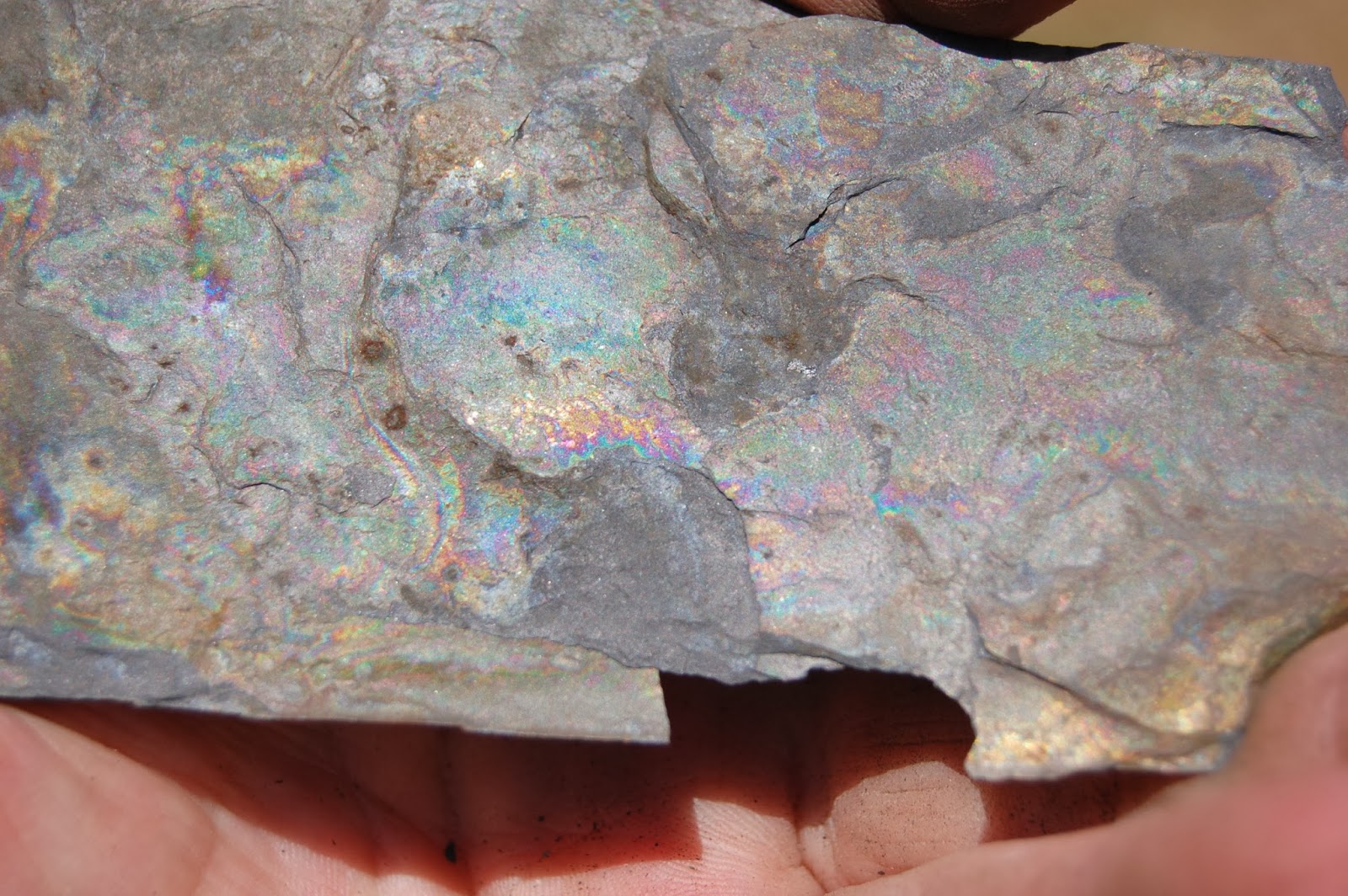
Geo 730: Jan. 28, Day 393: Rock Rainbow

Another shot of what I believe is secondary mineralization caused by weathering of pyrite and reprecipitation of metallic minerals on a cleavage plane of Galice slate. The rainbow colors are quite pretty.

Photo unmodified. May 8, 2013. FlashEarth Location. Indexed.