Sitting on the rim of the basalt flow here are three objects that the interpretive sign describes as lava balls. These are said to form in the same way as cartoon snowballs: a bit up high breaks loose and rolls down the slope of the active flow, accreting more lava as it goes, growing into a large, roughly spherically-shaped, ball. It makes good sense to me, but the reason I'm putting it into such equivocal terms is that I have never seen the name "lava balls" anywhere else, nor have I seen similar features in photos. I'm not suggesting anything wrong, nor any better explanation, just cautioning a bit of skepticism on this one.
Photo unmodified. August 21, 2011. FlashEarth location.
Miscellaneous thoughts on politics, people, math, science and other cool (if sometimes frustrating) stuff from somewhere near my favorite coffee shop.
Saturday, May 18, 2013
Friday, May 17, 2013
Geo 365: May 17, Day 137: 7000
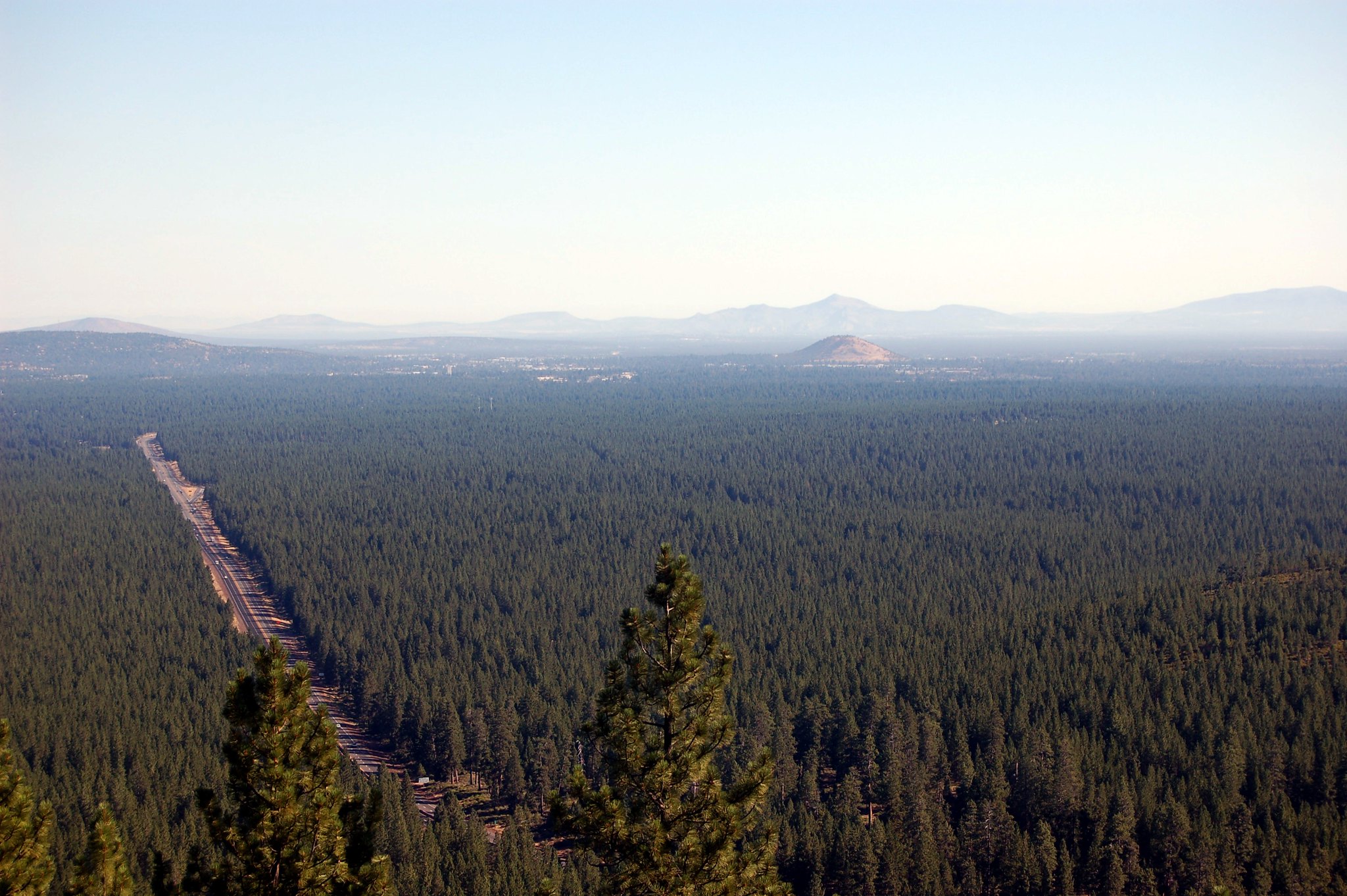
Reading the Wikipedia article yesterday, I found that this lava flow and Lava Butte are about 7000 years old. That's quite a bit of time in human terms, but not really enough in rock terms to allow weathering to create soils that will support plants. We do see some sage and rabbit brush here, but for the most part, it's barren rock. Mount Bachelor to the left, Three Sisters to the right on the horizon, and I think that's Broken Top as the lower peak in the middle.
Photo unmodified. August 21, 2011. FlashEarth location.
Photo unmodified. August 21, 2011. FlashEarth location.
Thursday, May 16, 2013
Geo 365: May 16, Day 136: Trail of the Molten Land
The interpretive trail on the breach flow at Lava Butte, looking north at that cinder cone. The summit road is apparent, spiraling up the peak. While the flow is pretty fresh, there are some colonizing pines visible.
Photo unmodified. August 21, 2011. FlashEarth location.
Photo unmodified. August 21, 2011. FlashEarth location.
Wednesday, May 15, 2013
Geo 365: May 15, Day 135: Jurassic Parking Lot
The closest Jurassic rocks are likely 150 miles away or so, in the Josephine ophiolite along I-5. Nevertheless, we found this Jeep fun, on our visit to Lava Butte. As yesterday, Three Sisters to the right, Mount Bachelor mostly behind the pine to the left.
Photo unmodified. August 21, 2011. FlashEarth location.
Photo unmodified. August 21, 2011. FlashEarth location.
Tuesday, May 14, 2013
Geo 365: May 14, Day 134: Cascade Skyline
Looking west from Lava Butte toward the Cascade crest. Three Sisters are to the right on the horizon, Mount Bachelor to the left, and I think that's Broken Top as the peak between them. The late-stage lava flow, which occurred after the cinder eruption, is visible at the foot of the peak. A version run through Paint.Net's autolevel routine can be viewed here.
Photo unmodified. August 21, 2011. FlashEarth location.
Photo unmodified. August 21, 2011. FlashEarth location.
Monday, May 13, 2013
Geo 365: May 13, Day 133: Pilot Butte
Looking roughly north-northeast from the top of Lava Butte, Pilot Butte in Bend stands out just below the horizon to the right of center. Of similar sizes, these two cinder cones are both likely to be parasitic cones on the flanks of Newberry Volcano.
Photo run through Paint.Net's autolevel routine. August 21, 2011. FlashEarth location.
Photo run through Paint.Net's autolevel routine. August 21, 2011. FlashEarth location.
Sunday, May 12, 2013
Sunday Funnies: Depression Edition
Hyperbole and a Half- I have never read descriptions of depression that capture my own feelings in dealing with it as lucid and, at the same time, as funny, as the ones by Allie Brosh. I'm not having any serious issues with the disease right now- beyond housekeeping- but while this is long, if you have someone in your life whose depression is confusing you, you should absolutely read this and try to appreciate what she's saying. Advice, however well and lovingly meant it may be, is more often than not off-target.
What Would Jack Do?
"When students blank on an essay question but still try to answer it (God bless them)" My Life as a College Professor
The Far Left Side
Funny to Me
Pygalgia
What Would Jack Do?
Bizarro
What Would Jack Do?
Cheezburger
"When someone asks if I'd rather be a volcanologist or paleontologist" Geology is Hard
Are You Talking to Meme?
GraphJam
Funny to Me
Blue Gal
Fake Science
Julia Segal
How I wish this would actually work. Funny to Me
Imgur
Senor Gif
ChannelAte
Fashionable Physicists, via Blackadder
Tastefully Offensive
Funny to Me
Tastefully Offensive
Imgur
Dork Tower
"Field work in Wyoming" Geology is Hard
Clay Bennett
Berkley Mews
Bits and Pieces
"Watching for cheaters when I give an exam" My Life as a College Professor
Firedoglake
Campanastan
Wil Wheaton's Tumblr
Dr. Boli
Julia Segal
What Would Jack Do?
"When students blank on an essay question but still try to answer it (God bless them)" My Life as a College Professor
The Far Left Side
Funny to Me
Pygalgia
What Would Jack Do?
Bizarro
What Would Jack Do?
Cheezburger
"When someone asks if I'd rather be a volcanologist or paleontologist" Geology is Hard
Are You Talking to Meme?
GraphJam
Funny to Me
Blue Gal
Fake Science
Julia Segal
How I wish this would actually work. Funny to Me
Imgur
Senor Gif
ChannelAte
Fashionable Physicists, via Blackadder
Tastefully Offensive
Funny to Me
Tastefully Offensive
Dork Tower
"Field work in Wyoming" Geology is Hard
Clay Bennett
Berkley Mews
Bits and Pieces
"Watching for cheaters when I give an exam" My Life as a College Professor
Firedoglake
Campanastan
Wil Wheaton's Tumblr
Dr. Boli
Julia Segal
Geo 365: May 12, Day 132: Ring Dikes
A panorama of three photos, taken at Otter Crest State Park. We're looking south here. At this scale, you can't make out the sea cave at Devil's Punchbowl, on the point in the top middle, but full-size, I can make out that dark spot. In response to a G+ query, I guessed that the reason for the ring shape (emphasis on guess) might be that as a lobate toe of the CRB flow responsible for this structure advanced out onto unconsolidated sediment, it hit a weak spot where it could plunge down and into the underlying beds. This in turn might allow a "rip" to propagate away from the initial invasion. So the rings, in this scenario, would echo the original flow front.
There are also some very obvious radial dikes, roughly perpendicular to the rings. The headland we're standing on here is also basalt, well above the raised marine terrace of Devil's Punchbowl and the inn to the upper left.
Photo stitched in Hugin. May 6, 2013. FlashEarth Location. (Cross hairs on viewpoint; the ring dikes should be pretty obvious in the cove to the south.)
Followup: Here's another panorama using the same shots, plus another one, redone with a better approximation of the correct focal length, suppressing much of the odd curvature.


