Friday, August 20, 2010

USGS, Ugh

The title is a bit of an overstatement I guess. I generally don't pay very close attention to USGS's Frequently Asked Questions; most I already know, and most of the remaining are questions I don't really care about. But the Q's and A's come through Ron Schott's Shared Items, so they get skimmed over, and from time to time... well, clunk. Here's the most recent example:

What are some examples of supervolcanoes?

Volcanoes that produced exceedingly voluminous pyroclastic eruptions and formed large calderas in the past 2 million years would include Yellowstone, Long Valley in eastern California, Toba in Indonesia, and Taupo in New Zealand. Other 'supervolcanoes' would likely include the large caldera volcanoes of Japan, Indonesia, Alaska (e.g. Aniakchak, Emmons, Fisher), and other areas.

That answer should also include a statement that "Supervolcano" doesn't really have a defined meaning, and isn't used by volcanologists or geologists generally. It was created as an attention-getter by the BBC. From Wikipedia,
The term "supervolcano" was originally used in the BBC popular science television program Horizon in 2000 to refer to these types of eruptions. That program introduced the subject of large-scale volcanic eruptions to the general public.

Volcanologists and geologists do not refer to "supervolcanoes" in their scientific work, since this is a blanket terms that can be applied to number of different geothermal conditions.
Here's another:

Why are there no faults in the Great Valley of central California?

The Great Valley is a basin, initially forming some ~100 million years ago as a low area between the subducting ocean plate on the west (diving down under the North American plate) and the volcanoes to the east (now the Sierra Nevada mountains). Since its formation, the Great Valley has continued to be low in elevation. Starting about 15 million years ago the tectonics changed in California and instead of the ocean plate diving down under the North American plate, it began to slide along it, with the ocean plate moving northward. This movement occurs along the San Andreas fault and the many other faults that are roughly parallel to it.

The faults on the east side of the Great Valley, mostly in Nevada, are the result of the North American plate pulling apart there, in a different tectonic setting that results in the linear mountain ranges and long valleys you can see there. The faults just to the east of the Great Valley are mostly old faults and may or may not still be active today. So there is movement of faults in two separate regimes: sideways motion along the San Andreas system to the west-southwest, and pull apart motion along the faults mostly in Nevada to the east-northeast of Sacramento.
Now that is actually a pretty nice answer, with lots of clear and succinct information. My quibble? There are almost certainly lots of faults in the Great Valley, but most if not all are not currently active. I'm not a big fan of the phrase "earthquake fault," but I do think it serves something of a purpose in helping people understand that some faults present a seismic risk of greater or smaller magnitude, but others do not. The fact that a particular fault isn't believed to be a potential earthquake risk doesn't make it "not-a-fault" though. And as I said, there are probably plenty of faults in the valley. They may not be mapped, though, because most of the bedrock is buried under a deep blanket of alluvial fill. So the above answer, while I like it generally, simply needs to clarify the distinction between active and inactive exposed faults and inactive obscured faults.

The third one, which really got under my skin, and was the reason I started setting these aside to see if there was a pattern, was this one:

What is a coral reef?

Coral reefs can be damaged by natural processes, such as storms, but they are increasingly at risk from human activities. Oil spills and pollutants can threaten entire reefs. Excessive nutrients from land sources, such as sewage and agricultural fertilizers, promote the growth of algae that can smother corals. Other organisms harmful to corals, such as crown-of-thorns starfish, multiply when the species that prey on them are removed.

Coral productivity is also decreased when land developments for agriculture, industry, and housing increase sediment transported from land into coastal waters as runoff. This clouds the waters and blocks light necessary for photosynthesis by algae living in corals. Corals face serious risks from various diseases. When corals are stressed, they often expel the algal symbionts that are critical to their health in a process commonly known as coral bleaching. One known cause of coral bleaching is increases in ocean temperatures, possibly due to global warming.

So, what's being done to protect coral reefs? Scientists worldwide are working to understand the impacts of natural processes and human activities on the health and sustainability of coral reefs. In the United States, this effort is being coordinated by the U.S. Coral Reef Task Force. As part of the task force, the USGS is contributing to the effort to understand the biological and geological controls that affect our Nation's coral reefs. USGS coral reef research focuses on detailed mapping of reefs, the development of monitoring techniques, studying reefs' geologic growth and development, and how they are affected by water quality, fishing, and sedimentary and hydrologic processes. These efforts will help provide information that is essential if coral reefs are to be saved.

Do you see anything in there that answers the question? It's not that risks to coral and reefs are unimportant, but the question posed is ignored, and in fact, the "answer" presumes that the reader already knows what a coral reef is. Here are the first two paragraphs from the Wikipedia page:
Coral reefs are underwater structures made from calcium carbonate secreted by corals. Corals are colonies of tiny living animals found in marine waters containing few nutrients. Most coral reefs are built from stony corals, and are formed by polyps that live together in groups. The polyps secrete a hard carbonate exoskeleton which provides support and protection for the body of each polyp. Reefs grow best in warm, shallow, clear, sunny and agitated waters.

Often called “rainforests of the sea”, coral reefs form some of the most diverse ecosystems on earth. They occupy less than 1% of the world ocean surface, about half the area of France, yet they provide a home for 25% of all marine species, including fish, molluscs, echinoderms and sponges.
Look, the USGS has, in any one of its employees, more geological expertise than I have or ever will have. I'm not sure what's going on here, and these are three chosen bits that stood out to me as being sub par, incomplete, or off the mark. I'm not by any means suggesting these are representative. But when I see better answers to geological questions at Wikipedia than from our National Geological Survey, it bugs me.

This I Believe

So one of the big news items of the last couple of days has been that nearly a fifth of Americans believe that the Obaminator is a Sooper Dooper Sekrit Mooslim. Whatever... I guess the reason it's news is that it's a significant increase in the percentage. I guess the reason I find this so underwhelming is I've learned never to underestimate American ignorance and gullibility. Via Matt Yglesias, here's a new Gallup Poll illustrating the point:Now here's the kicker: only 27% of those polled didn't believe any of the ideas in the above list- in other words, 73% believed in at least one item in the list. So basically, 20-25% of Americans will believe any sort of horseshit you shovel at them.

And we wonder how scammers and spammers do so well.

Big Pictures From Russia... In Color!

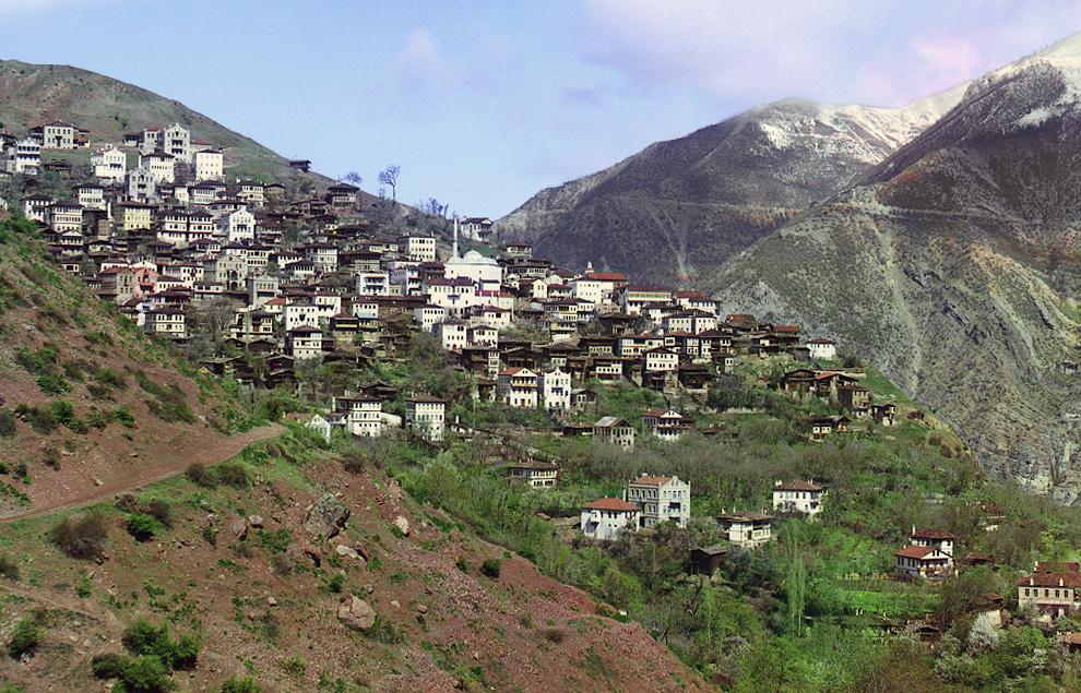
Today's Big Picture features 34 stunning color photos from from Russia a century ago.
...Sergei Mikhailovich Prokudin-Gorskii (1863-1944) undertook a photographic survey of the Russian Empire with the support of Tsar Nicholas II. He used a specialized camera to capture three black and white images in fairly quick succession, using red, green and blue filters, allowing them to later be recombined and projected with filtered lanterns to show near true color images.
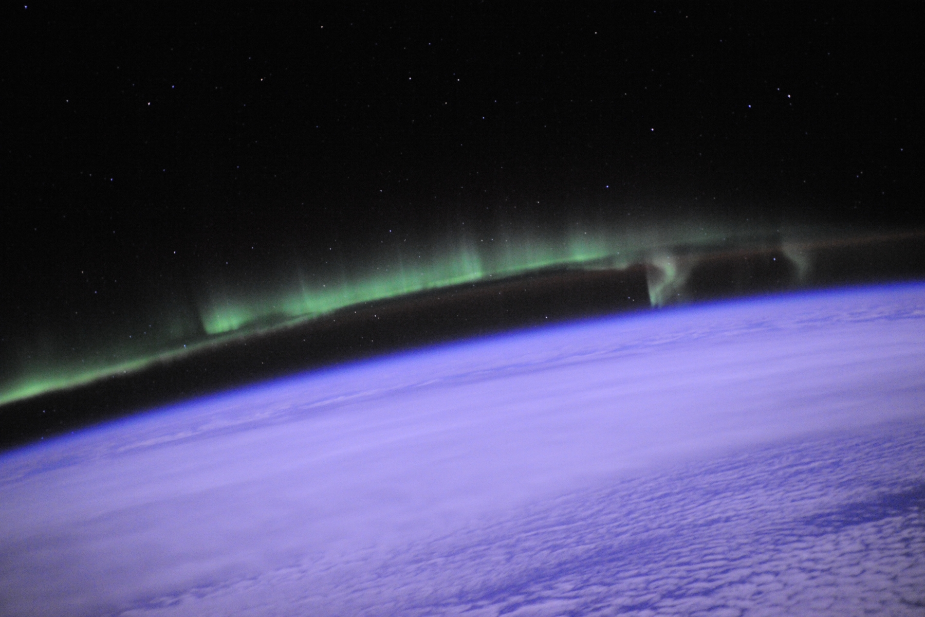
The colors are truly breath-taking and vivid. This is a priceless treasure. From Space Weather, another colorful photo today that blew me away was taken from the ISS. Click the pic for glorious full-size.

Thursday, August 19, 2010

Weather Underground WunderMap

Weather Underground WunderMap
Consider this a test. I just discovered the Weather Underground Wundermap a couple of days ago, and it does a great job of aggregating all sorts of weather data from around the area on one zoomable map. I just now realized I can post it to ze ol' blog, and I want to see if it posts the conditions in a static, fixed manner, or if it updates dynamically. I often enjoy documenting exciting weather (not that we're having any right now), so if it updates, I'll have to go with screen captures.

Followup: Oh, bother. It's just a link to the map. I coulda' done that.

Field Notes From An Idiot

I've seen this around in various places recently... typical wingnutty wasting of time and resources to make a meaningless statement, from someone who has no idea of the implications of the ideology he thinks he's rooting for. Yawn. An everyday occurrence in this dying country.
But the post that made me sit up and take note was at TYWKIWDBI yesterday, where it was pointed out that "he used Interstates, GPS and the internet which were all government funded projects..."

Dimensions

BBC has a fun project, "Dimensions," which allows you to plot various areas and distances against a landscape that's familiar to you. Above, the Mars Spirit rover almost made it to the outskirts of my little burg before becoming mired in a sandtrap on the far side of Witham Hill. The engine is somewhat limited: you can't rotate it, or shift it manually to begin and end in positions that better conform to locations you'd like, but this kind of thing really does help me get a sense of scale of things. For example, I've been reading about the awful flooding in Pakistan, but still hadn't had a gut sense of the area affected...By choosing a location that puts the ends near places with which I'm familiar- in this case, Enterprise, Or, near the Wallowa Mountains- allows me to see that the swath of destruction extends from Calgary, Alberta to near San Francisco. Wow. There are lots of these overlays, filed under various categories. Another fun one is the depth of the Marianas Trench, laid out as a north-south distance.

Wednesday, August 18, 2010

Local Water Blogs

A week or so ago, a young woman came up and introduced herself as Abby, and asked if I wasn't the person who did this blog... which, of course, I am. She then proceeded to flatter me mercilessly. I always feel a little awkward getting complimented, but you know, I can deal. So I asked her what she did, and she's a student in international water issues.

Now water isn't really my "thing," by which I mean it's interesting, but I've spent very little time actually learning about water issues. I had a single class in hydrogeology as an undergrad, which I found painfully tedious; I don't remember whether I dropped or flunked it. I know when I graduated I saw groundwater as one possible application of my geology degree that I could live with ethically; as much as I'm fascinated with ore minerals and their genesis and concentration, I don't want to be the person to walk into unspoiled land and say, "This looks like a mighty fine place to dig a city-sized hole." I'm glad there are people who can, and I envy them. But I'm afraid I'd feel awful doing that for a living. The point is, groundwater and remediation as a career choice just looked awful to me at the time.

On the other hand, I'm painfully aware of the importance of water issues in the arid west. Even here in "rainy" western Oregon, I'm afraid we take abundant water for granted. We haven't had any rain- to my knowledge- since mid-June. We had a near miss yesterday, and it did rain and thunder to the south of Corvallis. I like rain, and was pretty excited, then disappointed when it didn't make it here.

I have been following Todd Jarvis' Rainbow Water Coalition since early May, but Abby pointed me at a couple of other local water blogs: her own is Water for the Ages. She's in the midst of graduate student crunch right now, though, so posting is light. The other is Michael Campana's Water Wired, and the impetus for this post.

Today's piece is "So You Think You Know Western Water Law? Read 'Ten Water Laws of the West,'" and it's a hoot. I'll just excerpt the conclusion, and Campana ends each of his posts with a quote; I like this one, so it's included too. Click over and read the whole thing; if you're at all familiar with western US water issues, "you'll laugh until you cry."

Conclusion: The principles that govern Western water law and policy have a long and somewhat distinguished history. It should also be noted that similar arid environment ditch-dependent civilizations ultimately collapsed under extreme environmental stresses, internal political conflict, and invasion by barbarian hordes. This is worth contemplating during a drought with various water interests fighting over who will get water in times of future shortages while the streets of Santa Monica or Scottsdale or Tucson are filled with RVs with New Jersey license plates.
"Human beings were invented by water to transport it uphill." -- Unknown

And I'd be remiss not to mention Anne Jefferson, who in addition to broader geoblogging at Highly Allochthonous, also blogs on watery topics at Watershed Hydrogeology Blog. Anne is currently at UNC Charlotte, but did her PhD here at Oregon State on Cascades hydrogeology. As a result, I think of her as a "local" blogger.

Tuesday, August 17, 2010

Ground Zero

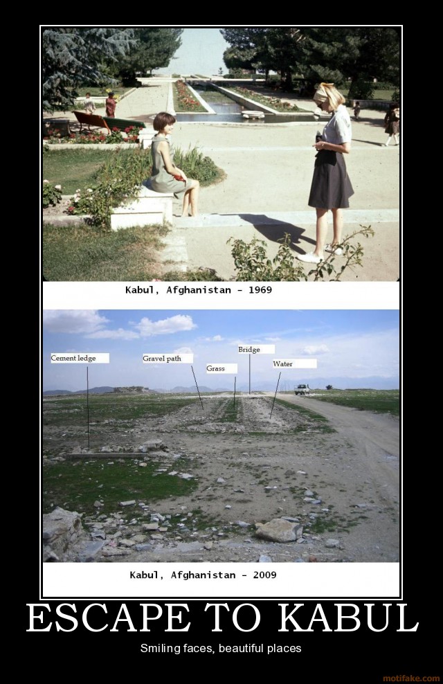
I had read that during the late sixties and early 70's Afghanistan was, if not a "first world" country, actually fairly modernized and prosperous. Then the Soviets invaded, and we funded and supplied arms for a counter-insurgency. We provided training in guerrilla tactics, and poured in weapons and ammunition. The Soviets gave up and left. The Taliban became the defacto government. Then educational descendants of those we trained attacked us, here at home. Then we invaded Afghanistan. It's easy to forget that the Afghani people have effectively lived under a state of continuous war for over thirty years now. And it's freaking mind boggling to actually see the changes wrought by those thirty years.What Would Jack Do? On a related note...
Darius Whiteplume's Tumblr

Tuesday Tits

A tit in the hand is a very nice thing indeed. I've fed chickadees like this; they're very inquisitive and bold. Blue tit, Cyanistes caeruleus, from here.

Monday, August 16, 2010

Rolling A Very Big And Many-Sided Die

There have been a number of stories implying that the scale and severity of the Russian drought and accompanying wildfires were in and of themselves so bad that they could only be ascribed to global warming. I have sort of winced at this idea, because as nasty as the situation is there, the whole point of the climate is to look for a long-term consistent pattern. And one, or even a few, data points, no matter how startling they may be, are not a very convincing demonstration of a pattern. So it was with some relief I read this article from CSM:
Mann said to think of the occurrence of these extreme events as rolling a loaded die. Rolling a six is like having a record-setting high temperature. With global warming, the die is loaded so that sixes come up increasingly more often — as if the numbers one, two and three were slowly being replaced with sixes.

Rolling a six, or having an extreme weather event, will become more common as the climate changes, Mann said. But rolling back-to-back sixes by chance alone will always be possible, regardless of global warming.

These double sixes, however, will come up far more often than would be expected in the absence of human-caused climate change — a trend that scientists are already seeing.
Now the nice thing about an article like that is that it clarifies the issue, shows that there is disagreement in the community and helps clarify what that disagreement is and why it exists. The problem with the former stories is that they're clear, and they're based on an understandable exaggeration. When that exaggeration is inevitably caught, it's blamed on science and scientists generally, not the specific scientist(s) and journalist(s) responsible. And as I expected, writers with denialist tendencies are all over this and other badly done reports.
The story states: “Worldwide temperature readings show that this January-June was the hottest first half of a year since record keeping began in the mid-19th century.” This implies that we are experiencing something unprecedented. Isn’t it strange that 60% of the U.S. had cooler than normal temperatures during this period. The article statement is untrue and due partially to NOAA computer programs actually manufacturing temperature readings where none exist.
Did you catch what he did there? “Worldwide temperature readings show that this January-June was the hottest first half of a year since record keeping began in the mid-19th century,” is untrue because according to this source, 60% of the US from January-July was cooler than normal.I have no reason to question the veracity of the High Plains Regional Climate Center, and I plan to look over their site when I have more time. But I find it odd that the opinionator would link to the image and not credit and link the site; it's as if in his ranting about NOAA "manufacturing" data, he didn't want anyone to notice HPRCC is part of NOAA's regional climate centers. Oh, and about that "manufacturing:" there are two maps in the National Climate Data Center's (NCDC) monthly report. Here's the first:And here's the second:Now his complaint is that NCDC/NOAA are "manufacturing" the data points in the second not present in the first, and avoids telling the reader that the first is in fact the first one shown, or even exists. "Manufacturing" implies to me "making up," and I did find this sort of startling, though I had some suspicions right away.

Sure enough, in its report, NCDC not only cites the means they're using to get the second chart, but links to the full paper. (~1 MB PDF) Yay, publicly available online peer-reviewed literature! To the extent I've been able to plow through it, it seems to confirm my guess: it adds in satellite data and interpolation. One passage says "The SST [sea surface temperatures] estimates from satellite, ships, and buoys are merged using a weighted sum of the different inputs, with weights inversely proportional to the noise estimate for each type." Now I'll grant that interpolation isn't as desirable as direct measurement, and I'm sure the algorithm isn't perfect. But it certainly isn't what came into my mind when I saw repeated uses of the phrase "manufacturing data," nor was the latter word choice accidental.

In conclusion, the author says
It didn’t take me too long to do some fact checking of this AP story. I wonder why AP or the Arizona Daily Star didn’t bother checking the facts. Could there be some political agenda in running such stories?
Nope, it doesn't take too long at all to bring up your contrarian, denialist bookmarks, and slap in a few that seem to fit, not link the NCDC you criticize, and instead use AP wire reports and press release stenographers as your straw man. Look, we know MSM science reporting is a disaster, and I appreciate that there is some value in criticism and skepticism. But if you want to go there, don't use AP as your proxy- go to the source. Fully link and credit your own sources. Be willing to engage with the ideas at hand- don't just dogmatically try to find contradictory evidence, and when you find one bit, assume that devastates the credibility of an overwhelming pile on the other side. The whole point of skepticism is not to be convinced, but to be willing to be swayed one direction or the other based on the evidence.

We are rolling a very big and many-sided die here, about eight thousand miles in diameter. I'd like to be confident we've got some kind of shot at winning this gamble.

"Hallowed Ground"

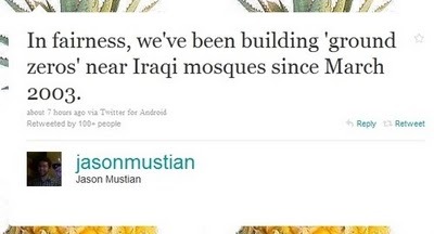
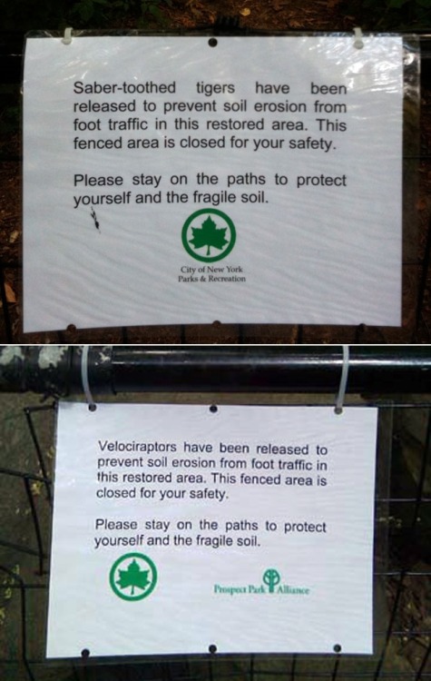
Here's a set of photos taken in Manhattan (these are the first two of about a dozen), about the same distance from ground zero as the planned Islamic Community Center (which, among many other things, will include a Mosque). Don't know if people remember this, but the reason Bin Laden declared war on the US and its citizens was the continuing presence of US troops in Saudi Arabia following the first Gulf war. Said country was considered by Bin Laden to be Hallowed Ground.Just sayin'...

Monday

Woke up at 3:30. Spent two hours trying to get back to sleep, then gave up. Early coffee today. It's Monday. Coincidence? I think not. (picture snagged from Facebook friend MB)

Sunday, August 15, 2010

Arid Lands

The NYT has an article and video clip promo for photographer Murray Fredericks' trekking about on Australia's Lake Eyre:
The Lake Eyre basin stretches across 750,000 square miles of inland Australia, draining nearly a quarter of the continent’s land mass. During the rare rainy season, Lake Eyre fills with water; the rest of the time, its lake bed forms a vast salt flat the size of Holland.
Fredricks has an online gallery here; the photos are quite lovely.
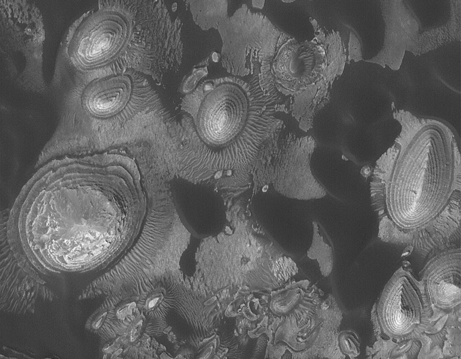
And continuing to promote astronomy with excellent geology, APOD today shows hills eroded from layered deposits on Mars

Sunday Funnies

Criggo
Pygalgia
Lolcats
Pundit Kitchen
Criggo
Dr. Boli
Alphaville
Sober in a Nightclub
The High Definite
Failblog
The Daily What
MthruF
Lolcats
Criggo
The Frogman
Puttin' on the Ritz... The Daily What
STFU, Believers
Criggo
Darius Whiteplume's Tumblr
Bits and Pieces
Bits and Pieces
So Much Pun
The Daily What
Señor Gif
Savage Chickens
This Modern World
Sofa Pizza
Savage Chickens
Pundit Kitchen... Apparently this is a real thing. The accompanying text says in part,
I’m almost certain we’ll see something about Hamid Karzai converting to Christianity before the end of August from at least one of the major media outlets like Fox News or MSNBC. But who will it be? Who will fall for the rumor? Anyone care to make a guess?

Pharyngula
ChannelAte
Friends of Irony
Darius Whiteplume's Tumblr
b3ta
The Daily What
Engrish Funny
Chew-Bach-A... So Much Pun
Bits and Pieces
Oddly Specific
Bits and Pieces
So Much Pun
Buttersafe
Darius Whiteplume's Tumblr
Sofa Pizza
Oddly Specific
So Much Pun. Also, 2000 mockingbirds make 2 kilomockingbird.
Pundit Kitchen
BizarroBlog
"It's funny because that’s what you call people that point out what everyone else already knows." The High Definite
The Daily What: Not sure if this is for real or a well-done spoof...
Wants her
see more Lol Celebs
The Daily What
Criggo
Señor Gif
Non Sequitur